
Zagarolo
| Zagarolo | ||
|---|---|---|

|
|
|
| Country | Italy | |
| region | Lazio | |
| Metropolitan city | Rome (RM) | |
| Coordinates | 41 ° 50 ′ N , 12 ° 50 ′ E | |
| height | 303 m slm | |
| surface | 28 km² | |
| Residents | 18,371 (Dec 31, 2019) | |
| Population density | 656 inhabitants / km² | |
| Post Code | 00039 | |
| prefix | 06 | |
| ISTAT number | 058114 | |
| Popular name | Zagarolesi | |
| Patron saint | San Lorenzo Martire | |
| Website | Comune di Zagarolo | |

Zagarolo is an Italian municipality that belongs to the metropolitan city of Rome in the Italian region of Lazio , with 18,371 inhabitants (as of December 31, 2019).
geography
.svg)
Zagarolo is 36 km east of Rome and 6 km west of Palestrina . The old town of Zagarolo is located on a two-kilometer long tuff hill between two valleys, roughly in the middle between the Alban Mountains and the Monti Prenestini. It is located below Palestrina between Via Prenestina and Via Casilina . The suburb of Valle Martella is located along Via Prenestina Nuova. The municipality extends over a height of 65 to 450 m slm
The community is located in earthquake zone 2 (medium risk).
Zagarolo is a member of the Comunità Montana dei Castelli Romani e Prenestini .
The neighboring municipalities are Gallicano nel Lazio , Palestrina , Rocca Priora , San Cesareo , Monte Compatri and Rome, clockwise .
traffic
-
 Zagarolo is 8 km from the driveway San Cesareo on the feeder road to the motorway A1 Autostrada del Sole removed.
 -
 Zagarolo is accessed from the Via Casilina (state road SS 6), which connects the place with Rome.
 -
 The commune is also crossed by the SS 155 that goes from San Cesareo to Frosinone .
-
 Zagarolo has a train station on the Rome – Cassino – Naples regional line, 3 km from the town center. It is also a stop on the FL6 Rome – Cassino regional train line .
-
 The nearest international airport, Rome Fiumicino, is 57 km away.
history
It is possible that the hill of Zagarolo was settled from the Latin city of Gabii in ancient times. However, the place only becomes comprehensible in documentary terms when Pope John XIII. in 970 to his sister Stefania and with it the Count of Tusculum . After their downfall, Zagarolo came to the Colonna family . During the clashes between the Colonna and the Pope, the place was destroyed several times. In 1670 it was sold to the Rospigliosi , whose building activity gave the old town its current appearance. The Palazzo Rospigliosi, which dominates the city, was only sold to the municipality in 1980.
Population development
| year | 1881 | 1901 | 1921 | 1936 | 1951 | 1971 | 1991 | 2001 | 2011 |
|---|---|---|---|---|---|---|---|---|---|
| Residents | 5,512 | 5,415 | 5,140 | 5,477 | 6.107 | 7.004 | 10,047 | 12,735 | 16,930 |
Source ISTAT
politics
Lorenzo Piazzai ( PD ) was elected mayor in May 2015. His center-left alliance also has the majority in the municipal council with 10 out of 16 seats. He replaced his fellow party member Giovanni Paniccia (2010-2015), who was no longer a candidate.
Mayor of Zagarolo:
- 2000–2010: Daniele Leodori ( PD ), now President of the Regional Assembly of the Lazio Region
- 2010–2015: Giovanni Paniccia (PD)
- since 2015: Lorenzo Piazzai (PD)
Twin cities
Attractions
- The Palazzo Rospigliosi dates back to a Colonna castle from the 11th century and was converted into a magnificent residence from the 16th century. Today it houses the Touro College Rome .
- The church of San Pietro, with its striking elliptical dome, was built from 1670.
- The Piazza Guglielmo Marconi represents a uniform Baroque composition with the Palazzo di Gonfalonieri (today the town hall), the Palazzo della Giustizia and the Church of San Lorenzo

Palazzo Rospigliosi

Dome of the Church of San Pietro
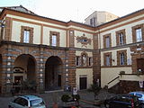
P alazzo di Gonfalonieri (City Hall)

Church of S to Lorenzo

.JPG)


Typical products
Wine is grown in Zagarolo, especially the white wine Zagarolo Tufaio DOC .
The Sagra dell'Uva , the festival of grapes, takes place on the first Sunday in October .
Sons and daughters
- Goffredo Petrassi (1904–2003), composer
- Angelo Infanti (1939-2010), actor
literature
- Axel Christoph Gampp: The periphery as the center: strategies of urban development in the Roman area 1600–1730. The examples Ariccia, Genzano and Zagarolo = manuscripts for art history in the Wernersche Verlagsgesellschaft 50. Wernersche Verlagsgesellschaft , Worms 1996. ISBN 978-3-88462-949-9
Web links
Individual evidence
- ↑ Statistiche demografiche ISTAT. Monthly population statistics of the Istituto Nazionale di Statistica , as of December 31 of 2019.
- ^ Italian civil defense
- ↑ Statistiche demografiche ISTAT . Population statistics from the Istituto Nazionale di Statistica, as of December 31, 2011.
- ^ La Repubblica , accessed June 26, 2015.
- ^ Information from the Ministry of the Interior

Affile | Agosta | Albano Laziale | Allumiere | Anguillara Sabazia | Anticoli Corrado | Anzio | Arcinazzo Romano | Ardea | Ariccia | Arsoli | Artena | Bellegra | Bracciano | Camerata Nuova | Campagnano di Roma | Canale Monterano | Canterano | Capena | Capranica Prenestina | Carpineto Romano | Casape | Castel Gandolfo | Castel Madama | Castel San Pietro Romano | Castelnuovo di Porto | Cave | Cerreto Laziale | Cervara di Roma | Cerveteri | Ciampino | Ciciliano | Cineto Romano | Civitavecchia | Civitella San Paolo | Colleferro | Colonna | Fiano Romano | Filacciano | Fiumicino | Fonte Nuova | Formello | Frascati | Gallicano nel Lazio | Gavignano | Genazzano | Genzano di Roma | Gerano | Gorga | Grottaferrata | Guidonia Montecelio | Jenne | Labico | Ladispoli | Lanuvio | Lariano | License | Magliano Romano | Mandela | Manziana | Marano Equo | Marcellina | Marino | Mazzano Romano | Mentana | Monte Compatri | Monte Porzio Catone | Monteflavio | Montelanico | Montelibretti | Monterotondo | Montorio Romano | Moricone | Morlupo | Nazzano | Nemi | Nerola | Nettuno | Olevano Romano | Palestrina | Palombara Sabina | Percile | Pisoniano | Poli | Pomezia | Ponzano Romano | Riano | Rignano Flaminio | Riofreddo | Rocca Canterano | Rocca di Cave | Rocca di Papa | Rocca Priora | Rocca Santo Stefano | Roccagiovine | Roiate | Rome | Roviano | Sacrofano | Sambuci | San Cesareo | San Gregorio da Sassola | San Polo dei Cavalieri | San Vito Romano | Sant'Angelo Romano | Sant'Oreste | Santa Marinella | Saracinesco | Segni | Subiaco | Tivoli | Tolfa | Torrita Tiberina | Trevignano Romano | Vallepietra | Vallinfreda | Valmontone | Velletri | Vicovaro | Vivaro Romano | Zagarolo