
Ariccia
| Ariccia | ||
|---|---|---|

|
|
|
| Country | Italy | |
| region | Lazio | |
| Metropolitan city | Rome (RM) | |
| Coordinates | 41 ° 43 ' N , 12 ° 40' E | |
| height | 412 m slm | |
| surface | 18 km² | |
| Residents | 18,618 (Dec 31, 2019) | |
| Population density | 1,034 inhabitants / km² | |
| Post Code | 00072 | |
| prefix | 06 | |
| ISTAT number | 058009 | |
| Popular name | Ariccini, in the dialect Aricciaroli | |
| Patron saint | St. Apollonia | |
| Website | Ariccia | |
 View of the old town of Ariccia |
||

Ariccia (pronunciation: arit͡ʃa ), historically Aricia , is an Italian municipality that belongs to the metropolitan city of Rome in the Italian region of Lazio , with 18,618 inhabitants (as of December 31, 2019).
geography
.svg)
Ariccia is located 26 km southeast of Rome and 13 km west of Velletri . The municipality is located in the volcanic Albanian Mountains on the Via Appia and belongs to the municipalities of the Castelli Romani . The old town lies above the Vallericcia crater on a mountain promontory that is delimited by two deeply cut valleys. The Via Appia crosses these cuts with two large bridges that shape the cityscape. The municipal area extends over a height of 125 m slm to 650 m slm
The northern suburb area occupies the ridge between Lake Albano and Lake Nemisee . In the valley, the former crater with a lake that has been drained since the Middle Ages, lies the district of Moletta, beyond the crater the districts of Cecchina and Fontana di Papa, where most of the community's residents now live.
The community is located in earthquake zone 2 (medium risk).
The neighboring municipalities are Albano Laziale , Rocca di Papa , Nemi , Genzano di Roma , Lanuvio , Aprilia ( LT ) and Ardea in clockwise order .
traffic
-
 Ariccia is 17 km from the driveway Monteporzio Catone on the feeder road to the motorway A1 Autostrada del Sole removed.
 -
 The main trunk road is the SS 7 Via Appia , which crosses the town.
 -
 The southern districts are accessed from the Via Nettunense (state road SS 207), which branches off from the Via Appia and leads to Anzio .
 -
 The Cancelliera station in the regional rail line FR4 Rome Velletri is located 6 km west of the town center.
 -
 The nearest international airport, Rome Fiumicino, is 43 km away.
history
According to Cassius Hemina , Ariccia, ancient Aricia, was founded by a Siculist leader named Archilochus.
The core of the ancient Aricia or its acropolis was 400 m above sea level above the elliptical volcanic Vallericcia valley at the location of today's old town. Remains of the fortifications have been preserved.
The ancient lower town lay on the slope of the Acropolis, below today's old town. The ancient Via Appia ran south of the modern road through the valley coming from the direction of today's Albano and rose again to the crater rim before today's Genzano. Its course is roughly today's Via Appia Antica. Ariccia was the first stop ( Mansio ) on the Via Appia. Parts of the city wall of the lower town, a temple and several houses have been preserved.
Aricia was one of the oldest cities in Lazio and a serious competitor and opponent of Rome during its royal times and the early Roman Republic . She was a center of the cult of Diana with the sanctuary of Diana belonging to Aricia.
In the war of Lucius Tarquinius Superbus , the last king of Rome, against his former ally Lars Porsenna , his army under Porsenna's son, Aruns Porsenna, suffered a heavy defeat before Aricia by the Latins and Greeks under the tyrant Aristodemos of Kyme (504/503 BC) . Chr.).
In the Second Latin War in 338 BC Gaius Maenius conquered the city for Rome, after which Aricia became a Roman civitas sine suffragio (city without voting rights). Soon after, however, Aricia received full civil rights. Even during the Roman Empire, Aricia had a top magistrate in the style of a dictator , Aricia's council, as in Rome , was the Senate, and Aricia kept its own holidays.
During the Migration Period , Ariccia was sacked and was probably almost deserted. The place was not rebuilt until the Middle Ages. In 1473 it came into the possession of the Savelli . In the 17th century the place was expanded by Gian Lorenzo Bernini and Carlo Fontana on behalf of the Chigi family .
Population development
| year | 1871 | 1881 | 1901 | 1921 | 1936 | 1951 | 1971 | 1991 | 2001 | 2011 |
|---|---|---|---|---|---|---|---|---|---|---|
| Residents | 2.115 | 2,358 | 3,530 | 4,555 | 5,596 | 7.122 | 10,787 | 16,953 | 17,865 | 18,650 |
Source: ISTAT
politics
Roberto Di Felice (Lista Civica: Ariccia Nel Cuore, and others) was elected mayor on June 8, 2016 after the last local election.
Twin cities
-
 Lichtenfels (Upper Franconia)
-
 Cournon-d'Auvergne
-
 Prestwick , Scotland
-
 Santa Margherita di Belice , Sicily
Ariccia also sponsors the Western Sahara .
coat of arms
The nymph Egeria is depicted on a brown field against a blue sky with a scepter in her left hand and a bouquet of three flowers in her right hand.
religion
The majority of the inhabitants of Ariccia belong to the Roman Catholic religious community. The community belongs to the diocese of Albano and has three parishes.
Attractions
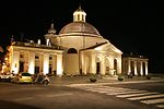
Santa Maria Assunta Church

View over the bridge to Ariccia

_Ariccia_001.jpg)
In the center of Ariccia is the church of Santa Maria Assunta, which was built by Bernini in 1664 , and the palace of Chigi, also by Bernini, with a wonderful park. An impressive, 312 m long viaduct along the Via Appia, built from 1847 to 1854 by Giuseppe Bertolini, leads from here to the neighboring town of Albano Laziale .
Optical Ilusion
In Via dell'Uccelliera, in the direction of Rocca di Papa , there is an optical illusion phenomenon . It gives the impression that you are moving upwards while the path actually leads downwards.
Similar phenomena can be seen on the A719 road on the Electric Brae mountain in Scotland and on the edge of Karpacz Górny (Bridge Mountain ) in Poland.
Culinary specialties
According to Pliny, even ancient Aricia was known for its vegetables and wine. Even today, the Vallericcia is important for growing vegetables and fruit. When it comes to wine production, the Fontana di Papa cooperative winery, founded in 1959, is the most important. Ariccia is an important destination for the residents of the greater Rome area. Above all, the many simple inns in the old town, which are known for the specialty porchetta (roast roast from suckling pig), are visited.
literature
- Axel Christoph Gampp: The periphery as the center: strategies of urban development in the Roman area 1600–1730. The examples Ariccia, Genzano and Zagarolo = manuscripts for art history in the Wernersche Verlagsgesellschaft 50. Wernersche Verlagsgesellschaft , Worms 1996. ISBN 978-3-88462-949-9
Web links
- Ariccia on www.comuni-italiani.it (Italian)
Individual evidence
- ↑ Statistiche demografiche ISTAT. Monthly population statistics of the Istituto Nazionale di Statistica , as of December 31 of 2019.
- ^ Italian civil defense
- ↑ a b Christian Hülsen : Aricia . In: Paulys Realencyclopadie der classischen Antiquity Science (RE). Volume II, 1, Stuttgart 1895, Col. 822 f.
- ↑ Johann Heinrich Westphal , The Roman Campaign presented in topographical and antiquarian terms , pp. 26–28. Berlin 1829. Digitized in the Google book search.
- ^ Edward Herbert Bunbury: Aricia . In: William Smith : Dictionary of Greek and Roman Geography. London 1854.
- ^ Homepage of the community
- ^ Ariccia Partnership Committee , accessed September 27, 2018.
- ^ Diocese of Albano (Italian), accessed December 20, 2015
- ↑ Homepage of the Palazzo Chigi
- ↑ Explanation of the optical illusion
- ^ Page of the Fontana di Papa winery , accessed on September 27, 2018

Affile | Agosta | Albano Laziale | Allumiere | Anguillara Sabazia | Anticoli Corrado | Anzio | Arcinazzo Romano | Ardea | Ariccia | Arsoli | Artena | Bellegra | Bracciano | Camerata Nuova | Campagnano di Roma | Canale Monterano | Canterano | Capena | Capranica Prenestina | Carpineto Romano | Casape | Castel Gandolfo | Castel Madama | Castel San Pietro Romano | Castelnuovo di Porto | Cave | Cerreto Laziale | Cervara di Roma | Cerveteri | Ciampino | Ciciliano | Cineto Romano | Civitavecchia | Civitella San Paolo | Colleferro | Colonna | Fiano Romano | Filacciano | Fiumicino | Fonte Nuova | Formello | Frascati | Gallicano nel Lazio | Gavignano | Genazzano | Genzano di Roma | Gerano | Gorga | Grottaferrata | Guidonia Montecelio | Jenne | Labico | Ladispoli | Lanuvio | Lariano | License | Magliano Romano | Mandela | Manziana | Marano Equo | Marcellina | Marino | Mazzano Romano | Mentana | Monte Compatri | Monte Porzio Catone | Monteflavio | Montelanico | Montelibretti | Monterotondo | Montorio Romano | Moricone | Morlupo | Nazzano | Nemi | Nerola | Nettuno | Olevano Romano | Palestrina | Palombara Sabina | Percile | Pisoniano | Poli | Pomezia | Ponzano Romano | Riano | Rignano Flaminio | Riofreddo | Rocca Canterano | Rocca di Cave | Rocca di Papa | Rocca Priora | Rocca Santo Stefano | Roccagiovine | Roiate | Rome | Roviano | Sacrofano | Sambuci | San Cesareo | San Gregorio da Sassola | San Polo dei Cavalieri | San Vito Romano | Sant'Angelo Romano | Sant'Oreste | Santa Marinella | Saracinesco | Segni | Subiaco | Tivoli | Tolfa | Torrita Tiberina | Trevignano Romano | Vallepietra | Vallinfreda | Valmontone | Velletri | Vicovaro | Vivaro Romano | Zagarolo