
Dew
| coat of arms | Germany map | |
|---|---|---|

|
Coordinates: 51 ° 54 ' N , 14 ° 27' E |
|
| Basic data | ||
| State : | Brandenburg | |
| County : | Spree-Neisse | |
| Office : | Peitz | |
| Height : | 61 m above sea level NHN | |
| Area : | 42.22 km 2 | |
| Residents: | 691 (Dec. 31, 2019) | |
| Population density : | 16 inhabitants per km 2 | |
| Postal code : | 03185 | |
| Area code : | 035601 | |
| License plate : | SPN, FOR, GUB, SPB | |
| Community key : | 12 0 71 384 | |
| Office administration address: | Schulstrasse 6 03185 Peitz |
|
| Mayoress : | Karin Kallauke | |
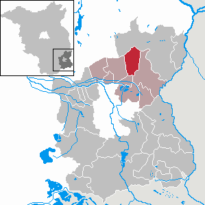
| Location of the municipality of Tauer in the Spree-Neisse district | ||
  |
||

Tauer , Turjej in Lower Sorbian , is a municipality in the Spree-Neisse district in the south of Brandenburg . It is part of the Peitz office .
geography
The community is located in the traditional settlement area of the Sorbs / Wends at the transition to the Vorspreewald. In the area of the municipality, the large lake, which emerged from an Ice Age depression, is located in the middle of a landscape conservation area and with numerous forests.
Community structure
The municipality of Tauer includes the district Schönhöhe ( Sorbian Šejnejda ) and the residential areas Försterei Großsee ( Gólnikaŕnja pśi Maznikojskem Jazorje ) and tar furnace ( Mazniki ).
history
The discovery of an urn grave field from the Bronze Age in the 19th century suggests a very early settlement of the place. In 1632 the community was first evidently mentioned as "Tawern". As early as 1652 the place was called "Taurow". The Schönhöhe district had existed as an arable farm since 1742. As part of the settlement policy of Frederick II , a two-row street village was created here from 1752, in which families predominantly from Saxony were settled at the time. The Teerofen colony (today the Teerofen residential area) on the Großsee, which had existed since 1665, became known for its tar and pitch extraction. In 1852 the tar distillery was closed. Many local residents emigrated to Australia and North America in the mid-19th century.
Tauer belonged to the Cottbus district in the Prussian province of Brandenburg since 1816 and to the Guben district in the GDR district of Cottbus from 1952 . The community has been in the Spree-Neisse district of Brandenburg since 1993.
In 1993 Schönhöhe was incorporated into Tauer.
Population development
|
|
|
|
|
Territory of the respective year, number of inhabitants: as of December 31 (from 1991), from 2011 based on the 2011 census
politics
Community representation
The community council of Tauer consists of eight community representatives and the honorary mayor. The local election on May 26, 2019 resulted in the following distribution of seats:
| Party / group of voters | Seats |
|---|---|
| SV 1920 Tauer | 3 |
| Citizens' Community Tauer / Schönhöhe | 1 |
| We for Tauer | 1 |
| Grill club GSG Tauer | 1 |
| Tauer volunteer fire brigade | 1 |
| FDP | 1 |
mayor
- 1998–2003: Monika Riese
- 2003-2014: Dieter Sommer (FDP)
- since 2014: Karin Kallauke (We for Tauer)
Kallauke was elected in the mayoral election on May 26, 2019 with 63.8% of the valid votes for a further term of five years.
coat of arms
The coat of arms was approved on May 9, 2012.
Blazon : "In green over a golden shield base, covered with a lying green ash branch, a striding, resisting golden aurochs."
The coat of arms was designed by the heraldist Uwe Reipert.
flag
The flag is striped green - yellow - green (1: 5: 1) and has the municipal coat of arms in the median.
Attractions

The list of monuments in Tauer includes the monuments entered in the list of monuments of the state of Brandenburg.
- Buildings
- Church built in 1790
- Fire station with clock tower, built in 1896
- Local history museum in a former bakery
Economy and Infrastructure
- traffic
Tauer lies on the national road L 50 between Peitz and Guben .
The Tauer stop was on the single- track Cottbus – Frankfurt (Oder) line , on which passenger traffic was discontinued in 1996.
- Sports
SV 1920 Tauer (football, bowling, billiards, table tennis, volleyball)
Individual evidence
- ↑ Population in the State of Brandenburg according to municipalities, offices and municipalities not subject to official registration on December 31, 2019 (XLSX file; 223 KB) (updated official population figures) ( help on this ).
- ^ Service portal of the state administration Brandenburg. Tauer parish
- ↑ Historical municipality register of the state of Brandenburg 1875 to 2005. District Spree-Neisse . Pp. 26-29
- ↑ Population in the state of Brandenburg from 1991 to 2017 according to independent cities, districts and municipalities , Table 7
- ^ Office for Statistics Berlin-Brandenburg (Ed.): Statistical report AI 7, A II 3, A III 3. Population development and population status in the state of Brandenburg (respective editions of the month of December)
- ^ Result of the local election on May 26, 2019
- ↑ Results of the municipal elections in 1998 (mayoral elections) for the Spree-Neisse district ( memento of the original from April 17, 2018 in the Internet Archive ) Info: The archive link was inserted automatically and has not yet been checked. Please check the original and archive link according to the instructions and then remove this notice.
- ↑ Local elections October 26, 2003. Mayoral elections , p. 33
- ^ Result of the mayoral election on May 25, 2014
- ↑ Brandenburg Local Election Act, Section 73 (1)
- ^ Result of the mayoral election on May 26, 2019
- ↑ Coat of arms information on the service portal of the state administration of Brandenburg
Web links
- Municipality of Tauer on the side of the Peitz office
Briesen (Brjazyna) | Castle (Spreewald) (Bórkowy (Błota)) | Dissen-Striesow (Dešno-Strjažow) | Döbern (Derbno) | Drachhausen (Hochoza) | Drebkau (Drjowk) | Drehnow (Drjenow) | Felixsee (Feliksowy jazor) | Forest (Lausitz) (Baršć) | Groß Schacksdorf-Simmersdorf (Tšěšojce-Žymjerojce) | Guben (Gubin) | Guhrow (Góry) | Heinersbrück (Móst) | Jämlitz-Klein Düben (Jemjelica-Źěwink) | Jänschwalde (Janšojce) | Kolkwitz (Gołkojce) | Neisse-Malxetal (Dolina Nysa-Małksa) | Neuhausen / Spree (Kopańce) | Peitz (Picnjo) | Schenkendöbern (Derbno) | Schmogrow-Fehrow (Smogorjow-Prjawoz) | Spremberg (Grodk) | Tauer (Turjej) | Teichland (Gatojce) | Tschernitz (Cersk) | Turnow-Preilack (Turnow-Pśiłuk) | Welzow (Wjelcej) | Advertise (Vjerbno) | Meadow bottom (Łukojce)