
Meadow ground
| coat of arms | Germany map | |
|---|---|---|

|
Coordinates: 51 ° 42 ' N , 14 ° 34' E |
|
| Basic data | ||
| State : | Brandenburg | |
| County : | Spree-Neisse | |
| Office : | Döbern country | |
| Height : | 87 m above sea level NHN | |
| Area : | 50.44 km 2 | |
| Residents: | 1364 (Dec. 31, 2019) | |
| Population density : | 27 inhabitants per km 2 | |
| Postal code : | 03149 | |
| Primaries : | 035694 (only Gosda), 035695 | |
| License plate : | SPN, FOR, GUB, SPB | |
| Community key : | 12 0 71 414 | |
| Community structure: | 5 districts | |
| Office administration address: | Forster Strasse 8 03159 Döbern |
|
| Mayor : | Norman Schlueter | |
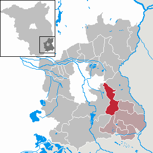
| Location of the municipality of Wiesengrund in the Spree-Neisse district | ||
  |
||

Wiesengrund , Łukojce in Lower Sorbian , is a municipality in the Spree-Neisse district and is located in the southeastern part of Brandenburg. It belongs to the Döbern-Land office , which is based in the city of Döbern . The community is located in the Sorbian settlement area .
geography
The municipality of Wiesengrund borders in the west on the independent city Cottbus and the municipality Neuhausen / Spree , in the south on the city Spremberg and the municipality Felixsee , in the east on the municipalities Neiße-Malxetal and Groß Schacksdorf-Simmersdorf and in the north on the district town of Forst ( Lausitz) and the municipality of Teichland . A residual hole from the lignite mining industry is being flooded in the municipality. The Klinger See is to be built from this by 2020.
There is also a geologically valuable Eem excavation in the Klinge district bordering the lake , which can be visited. The district of Mattendorf borders in the south on the foothills of the Muskau arch, which is also geologically interesting . The longest road connection from north to south is 15 km between Mattendorf (south) and Klinge (north); the municipality of Wiesengrund occupies a total area of 50 km².
Community structure
Wiesengrund consists of the following local and inhabited districts as well as residential areas:
- Gahry ( Lower Sorbian Garjej )
- Gosda ( Gózd ) with the municipality parts Dubrau ( Dubrawa ) and Klinge ( Klinka )
- Jethe ( Jaty ) with the municipality part Smarso ( Smaržow ) and the residential area Kreuzschänke ( Kśicna Kjarcma )
- Mattendorf ( Matyjojce )
- Trebendorf ( Trjebejce )
history
Gahry, Gosda, Mattendorf and Trebendorf belonged to the Cottbus district since 1816 , Jethe to the Sorau district in the Prussian province of Brandenburg . In 1952 all communities were incorporated into the Forst district in the GDR district of Cottbus . Since 1993 they have been in the Brandenburg district of Spree-Neisse.
The municipality of Wiesengrund was created as part of the Brandenburg municipal area reform through the voluntary merger of the municipalities of Gahry, Gosda, Jethe, Mattendorf and Trebendorf on December 31, 2001.
Population development
|
|
|
|
Territory of the respective year, number of inhabitants: as of December 31, from 2011 based on the 2011 census
religion
The villages of Gahry, Trebendorf and Mattendorf were already part of the Protestant parish of Komptendorf before 1906, as they do not have their own church. The church of Klinge was sacrificed for lignite mining in GDR times . Now the Klinger, Gosdaer and Dubrauer go to the half-timbered church in the Dubrau district.
politics
Community representation
The municipal council of Wiesengrund consists of 10 municipal representatives and the honorary mayor:
| Voter group | Seats |
|---|---|
| Free voter community Wiesengrund | 9 |
| Voting group Zukunft Wiesengrund | 1 |
(As of: local election on May 26, 2019)
mayor
- 2002–2019: Egbert S. Piosik (Free Wiesengrund Voting Association)
- since 2019: Norman Schlüter (Pro Trebendorf voter group)
Schlüter was elected in the mayoral election on May 26, 2019 with 52.0% of the valid votes for a term of five years.
Mayor
- Gahry: Klaus Vatter (since November 2, 2011)
- Gosda (with Dubrau and blade): Dieter Stodian (since 2003)
- Jethe (with Smarso): Dietmar Zech (since January 1, 2013)
- Mattendorf: Sigrun Grabinski (since July 1, 2019)
- Trebendorf: Reiner Brauer (since 2002)
Attractions
The list of monuments in Wiesengrund includes the monuments entered in the list of monuments of the State of Brandenburg.
- Zeitsprung open-air museum near Klinge am Klinger See
- Klinge station building (admission procedure)
Buildings
- Tiefkirche in the Gosda district
- Old sheepfold in the Gosda district
- Manor house in the Gahry district
- Castle in the Trebendorf district
- Half-timbered church in the Dubrau district
- Old school (built in 1907/08) in the Mattendorf district
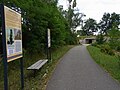
Entrance to the Zeitsprung museum

Tiefkirche in Gosda, replica of the steeple of the former Klinger Church

Old sheepfold Gosda
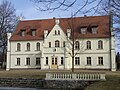
Gahry Manor, 2012

Half-timbered church in Dubrau


Parks
The old park between Trebendorf, Mattendorf and Gahry with the burial place of the previous owners of the Trebendorf Castle ( von Natzmer ) establishes the connection between the Gahry manor and the castle in Trebendorf.
Weather trail
There is a weather station in the Mattendorf district. The Wetter-Ost association began to set up a "weather trail" in 2006, which is intended to bring interested parties, especially children and young people, closer to the emergence of the weather (e.g. lightning machine, wind machine, but also energy generation with a new wind turbine) . On May 5, 2007, the prototype of a new (transverse) wind turbine was inaugurated in the presence of the Minister (and today's Prime Minister) Dietmar Woidke . This rises on the edge of the Muskau fold arch above Mattendorf.
traffic
Wiesengrund is on the L 49 regional road between Cottbus and Forst (Lausitz) . The L 481 connects the districts of Trebendorf and Gahry and leads to the federal road 115 (Forst– Döbern ). The federal motorway 15 ( triangle Spreewald - Polish border) crosses the municipality. The closest connection points are Roggosen and Forst .
Klinge station is on the Cottbus – Forst (Lausitz) railway line and is served by the regional train line RB 46 Cottbus - Forst (Lausitz) .
Individual evidence
- ↑ Population in the State of Brandenburg according to municipalities, offices and municipalities not subject to official registration on December 31, 2019 (XLSX file; 223 KB) (updated official population figures) ( help on this ).
- ↑ Press release State of Brandenburg: Wiesengrund belongs to the Sorbian settlement area. December 9, 2015, accessed July 9, 2016 .
- ↑ Law on the structuring of the rights of the Sorbs / Wends in the State of Brandenburg (Sorbs / Wends Act - SWG), annex. July 7, 1994, accessed July 9, 2016 .
- ↑ Main statute of the municipality of Wiesengrund from February 10, 2009 ( Memento from March 6, 2013 in the web archive archive.today )
- ^ Service portal of the state administration of the state of Brandenburg: Municipality of Wiesengrund
- ↑ Historical municipality register of the state of Brandenburg 1875 to 2005. District Spree-Neisse . P. 37
- ↑ Historical municipality register of the state of Brandenburg 1875 to 2005. District Spree-Neisse . Pp. 30-33
- ↑ Population in the state of Brandenburg from 1991 to 2017 according to independent cities, districts and municipalities , Table 7
- ^ Office for Statistics Berlin-Brandenburg (Ed.): Statistical report AI 7, A II 3, A III 3. Population development and population status in the state of Brandenburg (respective editions of the month of December)
- ^ Result of the local election on May 26, 2019
- ↑ Local elections October 26, 2003. Mayoral elections , p. 33
- ↑ Brandenburg Local Election Act, Section 73 (1)
- ^ Result of the mayoral election on May 26, 2019
Web links
Briesen (Brjazyna) | Castle (Spreewald) (Bórkowy (Błota)) | Dissen-Striesow (Dešno-Strjažow) | Döbern (Derbno) | Drachhausen (Hochoza) | Drebkau (Drjowk) | Drehnow (Drjenow) | Felixsee (Feliksowy jazor) | Forest (Lausitz) (Baršć) | Groß Schacksdorf-Simmersdorf (Tšěšojce-Žymjerojce) | Guben (Gubin) | Guhrow (Góry) | Heinersbrück (Móst) | Jämlitz-Klein Düben (Jemjelica-Źěwink) | Jänschwalde (Janšojce) | Kolkwitz (Gołkojce) | Neisse-Malxetal (Dolina Nysa-Małksa) | Neuhausen / Spree (Kopańce) | Peitz (Picnjo) | Schenkendöbern (Derbno) | Schmogrow-Fehrow (Smogorjow-Prjawoz) | Spremberg (Grodk) | Tauer (Turjej) | Teichland (Gatojce) | Tschernitz (Cersk) | Turnow-Preilack (Turnow-Pśiłuk) | Welzow (Wjelcej) | Advertise (Vjerbno) | Meadow bottom (Łukojce)