Yukon River
The Yukon River ( French Fleuve Yukon ) is a river that has its source in the Canadian province of British Columbia and then flows through the Yukon territory named after it before it flows into the Bering Sea in the US state of Alaska .
Due to its size and importance, most of the indigenous peoples living in its river system mostly referred to the river as the “Big River” or “Big, Wide River”. Therefore the name Yukon is only an Anglicization of the Gwich'in word Yu-kun-ah ("Great River"). Neighboring First Nations - like the Koyukon or Deg Hit'an - also called him Yookkene ("Big, wide river") or Yukkhane ("Big river").
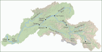
Yukon river system
The Yukon is 3120 kilometers long - counting from Tagish Lake - the fifth longest river on the North American continent. However, the Nisutlin River, together with the Teslin River and the middle and lower reaches of the Yukon, forms a 3185 kilometer long river. This rises a little further east in the Pelly Mountains , first flows south, flows into Teslin Lake into the Teslin River and then flows - as Teslin - in a north-westerly direction to flow into the Yukon at the village of Hootalinqua .
geography
The origin of the Yukon is in Marsh Lake in western Canada in the Coast Mountains about 200 kilometers east of the Pacific coast near the border of the province of British Columbia and the Yukon Territory. This is fed by the Tagish River , the outflow of Tagish Lake . The headwaters of the Yukon River include a number of larger lakes, in addition to Tagish Lake, these include Atlin Lake and Lake Bennett .
About 30 kilometers behind Marsh Lake, the Yukon breaks through the narrow, approximately two-kilometer-long Miles Canyon and is dammed behind in Schwatka Lake . As the comparison with historical photos shows, the water level in the canyon has risen by about six meters.
The dam of this lake is located south of downtown Whitehorse , the capital of the Yukon Territory. The foam-capped rapids, which are reminiscent of wild white horses and give the city its name, also sank into the waters of the lake. The reservoir is named after the US officer Frederick Schwatka , who explored the upper reaches of the river on a raft in 1883. Many geographical names with originally Indian names were renamed by him and still bear the new name today. The dam was provided with fish ladders to give salmon access to spawning waters more than 3000 kilometers from the sea (successful reintroduction, for example, at Wolf Creek ).
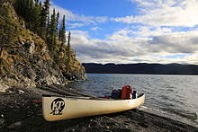
The following 740 kilometers of river, between Whitehorse and Dawson , are primarily of tourist importance today. Canoeists cover the scenic route in around 14 to 16 days using the currents of up to ten km / h ( whitewater difficulty scale in places I to II at high tide). About 20 kilometers north of Whitehorse the Yukon flows through Lake Laberge . The lake, 65 kilometers long and four kilometers wide, was created by expanding the river. The strong south-north winds that cause waves up to two meters high are feared here. The subsequent section to the confluence of the Teslin River is known as the Thirty Mile River . It is designated as a natural monument ( Canadian Heritage River ).
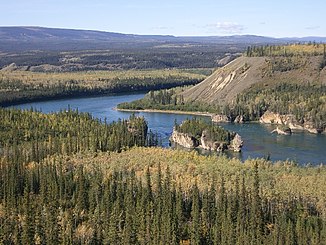
As far as Carmacks , the largest town between Whitehorse and Dawson with 391 inhabitants, the tributaries Big Salmon River and Little Salmon River from the east flow into the Yukon. The place is named after George Carmack , one of the discoverers of the Klondike gold claims . A few kilometers behind Carmacks are the Five Finger Rapids ("five-finger rapids"). Four rocks divide the current into five fingers and represented a major obstacle for paddle steamers in the 19th and 20th centuries that had to be overcome with winches and steel cables. This obstacle has been defused by rock blasting and can therefore now be easily overcome even by canoeists at normal water levels.
In Fort Selkirk, a former trading post, the Pelly River flows into the Yukon. Fort Selkirk is used and maintained as a fish camp by local First Nations in the summer . Some of the trading post buildings have been restored. Other important tributaries to Dawson are the White River and the Stewart River .
In Dawson , the Klondike River, known from the gold discoveries in 1896, flows into the stream. The state border between Canada and the United States lies at 141st longitude. A few kilometers downstream is Eagle , a supply center from the time of the gold rush, with 150 inhabitants today. About 15 kilometers behind the village, the Yukon reaches the border of the Yukon-Charley Rivers National Preserve . It is named after the Charley River tributary . The Yukon Flats National Wildlife Refuge , another nature reserve, is just 30 kilometers away. It is the third largest wildlife sanctuary in the United States. The landscape is flat here and the Yukon is therefore increasingly wider.
In the broad Yukon-Kuskokwim Delta , the river finally flows into the Bering Sea in the Yukon Delta National Wildlife Refuge .
history

The Yukon was already used as a transport route by the indigenous people.
During the Klondike gold rush, the Yukon was briefly of great importance as an access and supply route to Dawson, either as part of the route over the Chilkoot or White Pass ( Dead Horse Pass ), or with paddle steamers from the mouth.
From 1950 to 1955 the Klondike Highway connecting Whitehorse and Dawson was built . Due to the low bridges, the stern paddle steamers could no longer be used and river traffic was stopped.
As a transport route, the Yukon is only of local importance today. In contrast, its use as a tourist attraction is increasing.
See also
literature
- Andreas Kieling , Irena Bischoff: Yukon River Saga. Canoeing through Canada and Alaska . Heyne, Munich 2001, 303 pages, ISBN 3-453-17818-1
- Dirk Rohrbach: Yukon - 3000 kilometers in a canoe through Canada and Alaska . Malik National Geographic, Munich 2011, 302 pp., ISBN 978-3-492-40431-0
- Wolfgang Bittner : The salmon fishermen from the Yukon . C. Bertelsmann Verlag, Munich 1991. New edition: Laetitia Verlag 2006, ISBN 3-934824-24-2 .
- Christian Hannig: Yukon - Canada. From the Pacific through the tundra. With the bicycle under the constellation of the Great Bear to the Inuit, Donat Verlag: Bremen 2013, ISBN 978-3-943425-13-0
Documentary film
- Yukon adventure. Part 1: Through the wild heart of Canada & Part 2: The long way to the Arctic Ocean . German TV documentary by Andreas Kieling in two parts. ARD 2007, together approx. 90 minutes.
Web links
- Hydrographic measuring points in the catchment area of the Yukon River Lena and neighboring river systems
- National Park Service: Yukon-Charley Rivers National Preserve (official site; English)
- Yukon Flats National Wildlife Refuge
Individual evidence
- ↑ a b USGS: Environmental and Hydrologic Overview of the Yukon River Basin, Alaska and Canada (PDF; 6.5 MB)
- ↑ YUKON RIVER HYDROLOGY (PDF; 614 kB)
- Jump up ↑ further names of North- Atlas-speaking First Nations for the Yukon River, all of which mean "Great River": Tágà Shäw ( Southern Tutchone ), Tagé Cho ( Northern Tutchone ), Niga-to ( Tanana ); the Hän referred to it as Chu kon'dëk - "bubbling water river", but the Central Alaska Yupik (Yupiit) , who did not belong to the Northern Athapasques , also called it Kuigpak - "Great River"


