
Vogelsberger Höhen-Club
The Vogelsberger Höhen-Club (VHC) is a hiking club based in Schotten , which takes care of the development and maintenance of hiking trails in the eastern and central part of the Central Hesse region and the Wetterau . It is entered in the register of associations of the Friedberg District Court (VR 2015).
history
The club was on June 22, 1881 Founded in Scots as the home club to the Vogelsberg the tourism to promote. This should open up another source of income for the poor Vogelsberg population, whose situation deteriorated noticeably in the 19th century. The aim of the association when it was founded was "to make visiting the mountains more pleasant by setting up signposts, improving the mountain trails, creating viewpoints and resting places, instructing tourist guides and influencing the improvement of the inns". In addition, “knowledge of the mountains in terms of natural science, history and topography” should be promoted. The association was divided into rapidly growing branches: by September 1881, 14 such sections with over 300 members had already been founded.
Chairperson
At the first general assembly in Ulrichstein the members elected the tax commissioner Adalbert Klingelhöffer as the first president of the whole association. After Adalbert Klingelhöffer's death in 1885 “District Councilor Dr. Wolf from 1885 to 1888, followed by Chief Forester August Diefenbach (1888–1908), Chief Magistrate Richard Nispel (1908–1913), District Councilor Dr. Merk (1914–1920), the doctor Dr. Jakob Bruchhäuser (1920–1946), Dean Rudolf Widmann (1947–1953), the dentist Dr. Harald Eckhardt (1953–1975), the director of the Schotten Comprehensive School Werner Reitz (1975–1989), qualified engineer Peter Raven (1989–1999) and pharmacist Jürgen Uwe Klein, who heads the VHC from 1999 until today. "
Branch clubs
Within the first year, 17 branch associations were founded in the following locations: Alsfeld, Birstein, Büdingen, Darmstadt, Gedern, Gießen, Grünberg, Herbstein / Grebenhain, Hirzenhain, Homberg / Schweinsberg, Laubach, Lauterbach, Nidda, Ortenberg, Schlitz, Schotten and Ulrichstein. In the period that followed, further branch associations were formed in Altenstadt, Grebenhain, Herchenhain, Hungen, Kirtorf, Langen, Salzschlirf, Stockhausen, Lich and Wächtersbach / Schlierbach. In Homberg, Kirtorf, Langen, Stockhausen and Schlitz, the sections disintegrated again. In 1901 the Giessen Vosges Club joined the VHC as a branch association Taufstein. In 1902 there were 857 members, in 1907 3,000.
For its 125th anniversary in 2006, the VHC consists of 30 branch associations and more than 3500 members in the region between Giessen , Fulda and Frankfurt .
Facilities
- As early as 1887 the clubhouse "Berggasthof Hoherodskopf" was built on the Hoherodskopf .
- Next door, in the middle of the Hoher Vogelsberg Nature Park , which was founded after the VHC was founded , the "Vater-Bender-Heim" offers accommodation for hikers as a hiking home.
- On June 4, 1910, the 27 m high Bismarck Tower was inaugurated as a lookout tower made of gray hard basalt on the 773 m high baptismal font , the highest point on the Vogelsberg.
In addition, the branch associations maintain other migrant homes and observation towers.

Berggasthof Hoherodskopf

Bismarck tower on the font

Bismarck Tower entrance
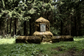
Monument near the Herchenhainer Höhe

VHC Clubhouse in Ulrichstein

Signposts for leisure trails - VHC and Vogelsberg Arena


tasks
Volunteer trailkeepers look after over 3000 km of marked hiking trails in Central Hesse and the Wetterau . The funding from the State of Hesse for this task is decreasing; Therefore, "the financing of path work should be changed by accepting commissioned work for municipalities for the maintenance and creation of the hiking trails." In addition to the trail maintenance, the VHC regularly organizes public hikes, offers free time, works with the foreigners' organizations, is active in the maintenance of local customs and traditions operates as a recognized nature conservation association in nature and landscape protection . In this function, he takes a position on interventions in nature and the landscape in accordance with Section 29 of the Federal Nature Conservation Act .
VHC hiking trails
- Vulkanring : hiking on the volcano, a 125 km long circular hiking trail
- Oberhessen -Weg : Gießen , Hangelstein, Beuern , Bersrod , Wirberg, Grünberg , Weickartshain, Freienseen, Oberseener Hof, Petershainer Hof , Feldkrücker Höhe, Hoherodskopf
- Lahn - Kinzig -Weg : Wetzlar , Dünsberg , Wettenberg , Gießen , Annerod , Albach , Münster , Laubach , Oberseener Hof, Rudingshain, Hoherodskopf, Taufstein , Herchenhainer Höhe (memorial), Hartmannshain, Volkartshain, Kirchbracht, Birstein , Eisenhammer, Schlierbach, Wächtersbach
- Europaweg E3 , European long-distance hiking trail Atlantic - Ardennes - Bohemian Forest , section Wetterau / Vogelsberg : Butzbach , Münzenberg , Bellersheim, Hungen , Schotten, Bilstein , Hoherodskopf, Lanzenhain, Herbstein , Blankenau, Fulda
- Taunus - Rhön - Weg : Bad Nauheim , Steinfurth , Münzenberg, Arnsburg Monastery , Lich , Nonnenroth, Laubach, Jägerhaus, Petershainer Hof, Ulrichstein, Dirlammen , Lauterbach, Steinberg, Schlitz
- Vulkan-Steig ( Vater-Bender-Weg ): Frankfurt-Seckbach , Lohrberg , Bergen , (via Hohe Straße) Ostheim, Langen-Bergheim , Grauer Stein, Herrnhaag , Büdingen , Michelau , Wenings , Ober-Seemen, Volkartshain, Hartmannshain, Herchenhainer Höhe, Taufstein , Hoherodskopf, Feldkrücker Höhe, Ulrichstein, Groß-Felda , Oberrod, Alsfeld
- Fürstenweg : Langenselbold , Ronneburg , Vonhausen , Büdingen, Bindsachsen, Wenings , Gedern , Herchenhain, Hoherodskopf, Ulrichstein, Totenköppel, Meiches, Allmenrod, Lauterbach
- Limesweg (Limeswanderweg, Wetterau section): Butzbach , Römerturm Pohlheim , Arnsburg Monastery, Hungen, Inheidener See , Steinheim, Unter-Widdersheim, Bisses, Bingenheim, Staden, Altenstadt , Langen-Bergheim, Ravolzhausen, Langendiebach, Rückingen, Großkrotzenburg
- More hiking trails
- Nature Park Cross Path (Laubach – Hartmannshain)
- Basalt Trail (Gedern – Ulrichstein)
- Vogelsberg-Spessart-Weg (Schotten– Schlüchtern )
- Lahn– Ohm –Weg (Gießen– Ober-Ohmen )
- Landgrafenweg ( Nidda -Ulrichstein)
- Wetterau – Spessart – Weg ( Echzell –Schlüchtern)
- Castle path ( Friedberg - Gelnhausen )
- Five Rivers Path ( Echzell Lanzenhain)
- Barbarossaweg (Gelnhausen – Hoherodskopf)
- Ohm – Kinzig – Weg ( Homberg (Ohm) - Wächtersbach )
- Pilgrimage route ( Stockheim - Blankenau)
- Baronenweg (Schlitz – Hoherodskopf)
- Ohm – Seental – path (Ober-Ohmen – Grünberg)
- Northwest Trail (Alsfeld – Grünberg)
- High altitude circular path on the Hoherodskopf
- Reffenstrasse ( Herrnhaag - Fulda)
- Stolberg – Ysenburg – Weg (Stockheim – Stockheim)
- Half-timbered hiking trail (Grünberg - Lich)
- Knot path (Alsfeld (Fulder Tor) - Lauterbach)
- Pilgrimage route (Ronneburg– Sternbacher Church )
- Nidda – Nidder – Weg (Nidda – Hirzenhain)
- Apple Trail (Nidda – Stockheim)
- Taufsteinweg (Bleichetal – Taufstein)
- Kinzigtalweg (Schlüchtern – Gelnhausen)
- Sternweg ((Hagen) –Ruppertenrod – Hoherodskopf)
- Fulda hiking trail (section Lüdermünd – Unterschwarz)
See also
Web links
- Vogelsberger Höhen-Club
- German Mountain and Hiking Associations Landesverband Hessen eV: regional associations
- Volcano - rise on the map
- Vogelsberg volcano ring on the map
- Nature park cross path on the map
- Basaltweg on the map
- Barbarossaweg on the map
- Reffenstrasse on the map
- Baronenweg on the map
- Northwest Trail on the map
- Altitude circular route on the map
- Pilgrimage route on the map
- Taufsteinweg on the map
- Sternweg on the map
- Knot path on the map
- Kinzigtalweg on the map
- Landgrafenweg on the map
- Fürstenweg on the map
- Lahn-Ohm-Weg on the map
- Vogelsberg - Spessart - route on the map
- Fuldawanderweg VHC on the map
- Nidda - Nidder - way on the map
- Taunus - Rhön - Weg on the map
- Stolberg - Ysenburg - Weg on the map
swell
- ↑ a b Schottener Kreisblatt, June 25, 1881
- ↑ VHC wants since 1881 "to make visiting the mountains more pleasant" ( Memento of September 27, 2007 in the Internet Archive ). In: Gießener Anzeiger , June 20, 2006
- ^ Dg: Vogelsberger Höhen-Club wants hiking to be more important ( memento of September 27, 2007 in the Internet Archive ) . In: Gießener Anzeiger , June 27, 2006