Haut-Vully
| Haut-Vully | ||
|---|---|---|
| State : |
|
|
| Canton : |
|
|
| District : | lake | |
| Municipality : | Mont-Vully | |
| Postal code : | 1787 Môtier 1789 Lugnorre |
|
| former BFS no. : | 2281 | |
| Coordinates : | 572930 / 199725 | |
| Height : | 434 m above sea level M. | |
| Area : | 7.47 km² | |
| Residents: | 1397 (December 31, 2014) | |
| Population density : | 187 inhabitants per km² | |
| Website: | mont-vully.ch | |
|
Môtier |
||
| map | ||
|
|
||
Haut-Vully (pronunciation: [o: ˈvɥi]) was a political municipality in the District du Lac (German: Seebezirk) in the canton of Friborg in Switzerland until December 31, 2015 . Until 1977 the municipality was officially called Vully-le-Haut . Despite the proximity to the language border, the former German name Oberwistenlach is rarely used today. On January 1, 2016, Haut-Vully and Bas-Vully merged to form the new municipality of Mont-Vully .
geography
Haut-Vully with the center of Môtier is 434 m above sea level. M. , three and a half kilometers northwest of the district capital Murten ( linear distance ). The village extends on the northern shore of Lake Murten , at the southern foot of Mont Vully , in the northern Freiburg Central Plateau .
The area of the 7.5 km² former municipal area comprises a section of the northern Freiburg Central Plateau in the Dreiseenland. The area has an approximately 3 km long lakeshore line on Lake Murten between the mouth of the Ruisseau de Forel in the west and Praz (Vully) in the east. From the lakeshore, the municipality extends northward over a 50 to 200 m wide flat edge of the bank to Mont Vully. The western part of this molasse mountain belongs to Haut-Vully. It has a plateau in the ridge area, which has its highest point at 623 m above sea level. M. achieved. The plateau gradually disappears towards the west and continues in the Mur plateau. Both the north and south sides of Mont Vully drop off steeply; while the southern slope is covered with vines, there is a dense forest area ( Bois du Mont ) on the northern slope .
To the north of Mont Vully, the former municipal area extends into the Great Moos plain and beyond the Broye Canal ( Canal de la Broye in French ) also includes the Le Rondet corridor with the Neuhof ( 431 m above sea level ). In 1997, 12% of the municipal area was in settlements, 13% in forests and woodlands, 72% in agriculture and around 3% was unproductive land.
Haut-Vully consists of several districts:
- Môtier, 434 m above sea level M. , at the southern foot of Mont Vully and on the banks of Lake Murten
- Lugnorre, 507 m above sea level M. , on a terrace on the southwest slope of Mont Vully, in a panoramic position around 80 m above the lake level of Lake Murten
- Joressens , 465 m above sea level M. , on the northwest slope of Mont Vully above the plain of Cudrefin
- Mur (Vully) , 485 m above sea level M. , on the edge of the plateau southwest of Mont Vully. The place is divided by the canton border, which runs along the Dorfstrasse, into the Friborg part of Mur (Vully) and the municipality of Mur in the Canton of Vaud .
- Guévaux , 439 m above sea level M. , on the small alluvial cone of the Ruisseau de Forel. The place is separated by the canton border into a Friborg and a Vaudois part.
Furthermore, some individual farms in the Grosse Moos belong to Haut-Vully. The neighboring communities of Haut-Vully were Bas-Vully in the canton of Friborg, Ins in the canton of Bern, and Cudrefin and Vully-les-Lacs in the canton of Vaud .
population
With 1,397 inhabitants (as of December 31, 2014), Haut-Vully was one of the medium-sized communities in the canton of Friborg. 58.3% of the residents are French-speaking, 36.5% German-speaking and 1.7% speak Portuguese (as of 2000). The population of Haut-Vully was 706 in 1850 and 729 in 1900. In the course of the 20th century, the population fluctuated in the range between 610 and 700 inhabitants. Only since 1980 (662 inhabitants) has there been significant population growth.
economy
Haut-Vully was a predominantly agricultural village until the second half of the 20th century . Even today arable farming , vegetable growing and fruit growing have an important place in the income structure of the population. On the lower southern slope of Mont Vully and below Mur, thanks to the optimal exposure to the sun, there is a contiguous wine-growing area (especially Chasselas grapes). Some residents also make a living from fishing.
Further jobs are available in local small businesses and in the service sector. In the villages there are gardening shops, carpenters, locksmiths and wine shops as well as companies in the transport and construction trades. In the last few decades, Haut-Vully has also developed into a residential community thanks to its attractive location. Many employees are therefore commuters, some of whom work in the immediate vicinity (Murten, Kerzers), but also in Neuchâtel and in the agglomeration of Bern because of the good transport links .
tourism
Haut-Vully also benefits from tourism thanks to the mild and beautiful location and the possibility of water sports on Lake Murten. To the west of Môtier there are numerous holiday and weekend houses along the lake shore.
traffic
The former municipality is very well developed in terms of traffic. It is located on a connecting road from Salavaux along the northern shore of Lake Murten to Sugiez. The closest connection to the A1 motorway (Bern-Lausanne) is around 8 km from the town center. Môtier and Mur are also connected to the public transport network via a postbus course that runs from Sugiez to Lugnorre. Môtier is connected to the other Seeanstösser communities through the passenger shipping on Lake Murten.
history
The municipality of Haut-Vully can look back on a very long history of settlement. Remains of pile dwellings and other traces of settlement from the Bronze Age have been discovered along the shore of Lake Murten . An oppidum on Mont Vully attests to the presence of the Celts , and the area was also inhabited during Roman times .
The place was first mentioned in a document in 968 under the name Wisliacense . Later, the names Vuisliacense (985), Williex (1192), Willie (1228), Villiaco , Wistillacho (1266), Williey (1330), Vuillie (1334), Wuilliacum and Vuilliez (1453). The name Vully goes back to a Gallo-Roman settler named Vistilius .
Since the 12th century, Lugnorre formed its own small lordship, which experienced frequent changes of ownership and at times belonged to the Counts of Neuchâtel, at times to the Lords of Grandson and later came under the influence of the Counts of Savoy. The latter sold the Lugnorre estate to the city of Murten in 1469 .
From 1484 the villages of today's Haut-Vully were subordinate to the bailiffs of Murten, which were jointly administered by the Bern and Friborg estates. After the collapse of the Ancien Régime (1798) they came to the canton of Friborg. During the Helvetic era , Môtier and Mur (Vully) belonged to the Murten district, while Lugnorre and Joressens were part of the Avenches district, which was then in Friborg. From 1803 all the villages and hamlets of today's Haut-Vully in the Murten district were united. With this they came to the lake district in 1848 as part of the new cantonal constitution. During the 1980s, a merger of the parishes of Haut-Vully and Bas-Vully was up for debate, but this failed because of the rejection of the voters of Bas-Vully.
On January 1, 2016, the two municipalities of Bas-Vully and Haut-Vully merged to form the new municipality of Mont-Vully.
Attractions
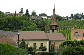
In Môtier is the reformed parish church of Saint-Pierre, which was probably founded in the 11th century. The current building shows a mixture of different styles: a Gothic choir from the 15th century, a Romanesque bell tower from the 12th and 13th centuries, while the nave was redesigned in 1824. The rectory dates from the 17th century.
The centers of Lugnorre and Môtier are characterized by characteristic wine-growing houses from the 16th to 19th centuries. In Môtier, Mur (Vully) and Guévaux there are stately mansions, mostly from around 1800.
A wine-growing nature trail (Sentier viticole du Vully) leads along the vineyards around 50 m above the lake level of Lake Murten, with a beautiful view of the wine-growing villages of Haut-Vully and, if the weather is clear, to the Alps. In the forest of Mont Vully there is a large boulder named Pierre Louis Agassiz , named after the naturalist Louis Agassiz , who was born in Môtier.
literature
- Hermann Schöpfer: Les monuments d'art et d'histoire du Canton de Friborg, Tome IV: Le District du lac (I). Edited by the Society for Swiss Art History GSK. Bern 1989 (Art Monuments of Switzerland, Volume 81). ISBN 3-909158-21-8 . Pp. 284-358.
Web links
- Official website of the municipality of Haut-Vully (French)
- Marianne Rolle: Haut-Vully. In: Historical Lexicon of Switzerland .
- Gilbert Marion: Guévaux. In: Historical Lexicon of Switzerland .
- Marianne Rolle: Lugnorre. In: Historical Lexicon of Switzerland .
- Marianne Rolle: Môtier. In: Historical Lexicon of Switzerland .
- Aerial views of Môtier
- Aerial photos of the Mur


