Wyoming County (New York)
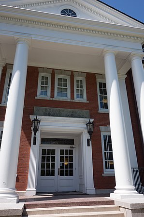
 Wyoming County Courthouse (2013) |
|
| administration | |
|---|---|
| US state : | new York |
| Administrative headquarters : | Warsaw |
| Foundation : | May 19, 1841 |
| Made up from: | Genesee County |
| Area code : | 001 585 |
| Demographics | |
| Residents : | 42,155 (2010) |
| Population density : | 27.5 inhabitants / km 2 |
| geography | |
| Total area : | 1,544.4 km² |
| Water surface : | 9.2 km² |
| map | |
| Website : www.wyomingco.net | |
Wyoming County is a county in the state of New York in the United States . At the 2010 census , Wyoming County had 42,155 residents and a population density of 27.5 people per square kilometer. The county seat is Warsaw .
geography
The county covers an area of 1,544.4 square kilometers, of which 9.2 square kilometers are water.
Surrounding areas
| Erie County | Genesee County | Livingston County |
| Erie County |

|
Livingston County |
| Cattaraugus County | Allegany County | Allegany County |
history
Wyoming County was separated from Genesee County on May 19, 1841 . This completed the administrative divisions in the western part of New York State.
As of April 21, 2017, 19 properties and 7 Historic Districts were listed on the National Register of Historic Places .
Population development
| year | 1800 | 1810 | 1820 | 1830 | 1840 | 1850 | 1860 | 1870 | 1880 | 1890 |
|---|---|---|---|---|---|---|---|---|---|---|
| Residents | - | - | - | - | - | 31,981 | 31,968 | 29,164 | 30,907 | 31,193 |
| year | 1900 | 1910 | 1920 | 1930 | 1940 | 1950 | 1960 | 1970 | 1980 | 1990 |
| Residents | 30,413 | 31,880 | 30,314 | 28,764 | 31,349 | 32,822 | 34,793 | 37,688 | 39,895 | 42,507 |
| year | 2000 | 2010 | 2020 | 2030 | 2040 | 2050 | 2060 | 2070 | 2080 | 2090 |
| Residents | 43,424 | 42,155 |
Cities and towns
In addition to the independent parishes listed below, there are several villages in Wyoming County .
| Locality | status | Population (2010) |
Total area [km²] |
Land area [km²] |
Population density [inhabitants / km²] |
founding | Specialty |
|---|---|---|---|---|---|---|---|
| Arcade | town | 4,205 | 122.0 | 121.7 | 34.6 | 6th Mar 1818 | Established under the name of China ; renamed on November 9, 1869 |
| Attica | town | 7,702 | 93.3 | 92.5 | 83.3 | Apr 4, 1811 | |
| Bennington | town | 3,359 | 143.1 | 142.6 | 23.6 | 6th Mar 1818 | |
| Castile | town | 2,906 | 99.4 | 95.8 | 30.3 | Feb. 27, 1821 | |
| Covington | town | 1,232 | 67.7 | 67.7 | 45.6 | Jan. 31, 1817 | |
| eagle | town | 1,192 | 94.5 | 94.0 | 12.7 | Jan. 21, 1823 | |
| Gainesville | town | 2,182 | 92.5 | 92.1 | 23.7 | Feb 25, 1814 | Founded under the name Hebe ; renamed on April 17, 1816 |
| Genesee Falls | town | 438 | 40.7 | 40.4 | 10.8 | Apr 1, 1846 | |
| Java | town | 2,057 | 122.6 | 122.1 | 16.8 | Apr 20, 1832 | |
| Middlebury | town | 1,441 | 92.4 | 92.3 | 15.6 | 20 Mar 1812 | |
| Orangeville | town | 1,355 | 92.3 | 92.1 | 14.7 | Feb. 14, 1816 | |
| Perry | town | 4,616 | 94.9 | 94.3 | 49.0 | 11th Mar 1814 | |
| pike | town | 1,114 | 80.9 | 80.5 | 13.8 | 6th Mar 1818 | |
| Sheldon | town | 2,409 | 122.7 | 122.6 | 19.6 | 19 Mar 1808 | |
| Warsaw | town | 5,064 | 91.9 | 91.7 | 55.2 | 19 Mar 1808 | County Seat |
| Wethersfield | town | 883 | 93.5 | 92.7 | 9.5 | Apr 12, 1823 |
literature
- Franklin Benjamin Hough: Gazetteer of the State of New York . 2nd volume. A. Boyd, Albany, NY 1873, pp. 711 ff . ( PDF 67.9 MB , accessed January 1, 2018).
Individual evidence
- ↑ Wyoming County in the United States Geological Survey's Geographic Names Information System
- ↑ Population 1850-2010 according to census results
- ↑ Population data from the 2010 US Census in the American Factfinder
- ↑ a b Official data of the United States Board on Geographic Names
- ^ Franklin Benjamin Hough: Gazetteer of the State of New York . 2nd volume. A. Boyd, Albany, NY 1873, pp. 713 ff .
Web links
Commons : Wyoming County, New York - collection of pictures, videos, and audio files
Coordinates: 42 ° 42 ′ N , 78 ° 14 ′ W
