Xylofagou
|
Xylofagou Ξυλοφάγου |
||
|---|---|---|
|
|
||
| Basic data | ||
| State : |
|
|
| District : | Larnaka | |
| Geographic coordinates : | 34 ° 59 ′ N , 33 ° 51 ′ E | |
| Height above d. M .: |
53 m |
|
| Residents : | 6231 (2011) | |
| LAU-1 code no .: | CY-03 | |
| Website: | xylophagou.com.cy | |
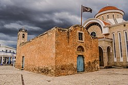
| Agios Georgios Church in Xylofagou | ||
Xylofagou ( Greek Ξυλοφάγου ) is a place in the Larnaka district in Cyprus . In 2011 the place had 6,231 inhabitants.
geography
The place is located in the south-east of the island of Cyprus at an altitude of about 53 m on the border with the British military base Dhekelia and the Cypriot district of Famagusta . In the west, about 2 kilometers from the town center, borders the bay of Larnaka . Places in the area are Agia Napa and Liopetri in the east, Avgorou in the north and Ormideia as a Cypriot enclave in the military area in the west.
traffic
Xylofagou is located on the A3 from the port city of Larnaka with Larnaka Airport to Agia Napa. The main road B3 (also coming from Larnaka) runs through the town and ends shortly afterwards at the motorway. This means that there are good transport links, especially in the west of Cyprus.
Web links
Individual evidence
- ↑ Statistical Service (download, accessed February 19, 2019)


