
Grace Village
|
Grace Village
|
||
|---|---|---|
| coat of arms | Austria map | |
 |
|
|
| Basic data | ||
| Country: | Austria | |
| State : | Lower Austria | |
| Political District : | Mistelbach | |
| License plate : | MI | |
| Surface: | 48.32 km² | |
| Coordinates : | 48 ° 37 ' N , 16 ° 24' E | |
| Height : | 272 m above sea level A. | |
| Residents : | 1,147 (January 1, 2020) | |
| Population density : | 24 inhabitants per km² | |
| Postal code : | 2152 | |
| Area code : | 02525 | |
| Community code : | 3 16 13 | |
| NUTS region | AT125 | |
| Address of the municipal administration: |
Gnadendorf 15 | |
| Website: | ||
| politics | ||
| Mayor : | Manfred Schulz ( ÖVP ) | |
|
Municipal Council : ( 2020 ) (19 members) |
||
| Location of Gnadendorf in the Mistelbach district | ||
  |
||
| Source: Municipal data from Statistics Austria | ||

Gnadendorf is a municipality with 1147 inhabitants (as of January 1, 2020) in the Mistelbach district in Lower Austria .
geography
Gnadendorf is located in the Zaya Valley on the northern edge of the Leiser Mountains in the Weinviertel in Lower Austria, around 15 km west of Mistelbach . The area of the municipality covers 48.25 square kilometers. 32.95 percent of the area is forested.
In the municipality is the summit of the 491 m high Buschberg , the highest point in the Weinviertel region, which is easily recognizable from afar thanks to the radar station built on it.
Community structure
The municipality includes the following seven localities (population in brackets as of January 1, 2020):
- Eichenbrunn (273) including Weyhmühle
- Gnadendorf (265) including Neustift
- Oedenkirchenwald (3)
- Pyhra (227) including the Buschbergsiedlung and Regenbogensiedlung
- Röhrabrunn (132)
- Wenzersdorf (69)
- Zwentendorf (178)
The community consists of the cadastral communities Eichenbrunn , Gnadendorf, Oedenkirchenwald, Pyhra, Röhrabrunn, Wenzersdorf and Zwentendorf.
Neighboring communities
history
The place was first mentioned in 1113 as "Gnannendorf".
The place suffered greatly from the border fights with Hungary and Bohemia. The owners of the place changed frequently. In 1543, Christoph Kuenritz found himself as the owner, his grandchildren sold Hagenberg and Gnadendorf in 1650 to the brothers Leo and Sigmund Friedrich von Sinzendorf , whose descendants were recorded until 1822. Their successors were the Reuss-Köstritz in 1828. The high altar picture in the Assumption of Mary was badly damaged by an artillery hit in 1945 when the Red Army marched in. In 2000 the grave of a 14 to 18 year old early Hungarian cavalier was discovered and excavated in Gnadendorf. Two radiocarbon dates date the burial to around the year 1000.
Population development
According to the results of the 2001 census , there were 1,175 inhabitants. In 1991 the municipality had 1,203 inhabitants, in 1981 1,230 and in 1971 1,401 inhabitants.
politics
The municipal council has 19 members.
- With the municipal council elections in Lower Austria in 1990, the municipal council had the following distribution: 17 ÖVP and 2 SPÖ.
- With the municipal council elections in Lower Austria in 1995, the municipal council had the following distribution: 17 ÖVP and 2 SPÖ.
- With the municipal council elections in Lower Austria in 2000, the municipal council had the following distribution: 16 ÖVP, 2 SPÖ and 1 FPÖ.
- With the municipal council elections in Lower Austria in 2005 , the municipal council had the following distribution: 16 ÖVP and 3 SPÖ.
- With the municipal elections in Lower Austria in 2010 , the municipal council had the following distribution: 16 ÖVP and 3 SPÖ.
- With the municipal council elections in Lower Austria in 2015 , the municipal council had the following distribution: 16 ÖVP and 3 SPÖ.
- With the municipal council elections in Lower Austria 2020 , the municipal council has the following distribution: 14 ÖVP, 4 GNADE – Die Gnadendorfer Democrats and 1 SPÖ.
- mayor
- until 2014 Franz Schmidt (ÖVP)
- since 2014 Manfred Schulz (ÖVP)
coat of arms
,_Siebmachers_Wappenbuch,_vereinzelt.png)
The coat of arms of the municipality reminds, among other things, of the Bavarian-Austrian lords of Sinzendorf with the elements of their main coat of arms .
Culture and sights
- Wenzersdorf castle ruins
- Catholic parish church Eichenbrunn hl. Koloman
- Catholic parish church Gnadendorf hl. John the Baptist
- Catholic parish church Pyhra hl. Body of Christ
- Wenzersdorf Catholic Parish Church of the Annunciation
- Marien Chapel in the picture oak forest
- Grainkapelle between Röhrabrunn and Eichenbrunn
- Our dear lady chapel in Röhrabrunn
- Chapel of the Good Shepherd and Kellergasse in Zwentendorf
- Forest house in Ödenkirchwald
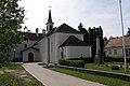
Pyhra Parish Church

Kellergasse in the back in Eichenbrunn

.JPG)


economy
In 2001 there were 42 non-agricultural workplaces, agricultural and forestry operations 114 according to the 1999 survey. According to the 2001 census, the number of people in employment at home was 509. The 2001 activity rate was 44.34 percent.
literature
- Falko Daim (ed.): Hero's grave in no man's land. An early Hungarian rider from Lower Austria (mosaic stones volume 2). Publisher of the Römisch-Germanisches Zentralmuseum Mainz, Mainz 2006, ISBN 978-3-7954-1964-6
Web links
- http://www.gnadendorf.at
- 31613 - Gnadendorf. Community data, Statistics Austria .
Individual evidence
- ↑ Statistics Austria: Population on January 1st, 2020 by locality (area status on January 1st, 2020) , ( CSV )
- ^ Result of the local council election 1995 in Gnadendorf. Office of the Lower Austrian State Government, March 30, 2000, accessed on March 18, 2020 .
- ^ Election result of the municipal council election 2000 in Gnadendorf. Office of the Lower Austrian State Government, February 4, 2005, accessed on March 18, 2020 .
- ^ Election result of the municipal council election 2005 in Gnadendorf. Office of the Lower Austrian State Government, March 4, 2005, accessed on March 18, 2020 .
- ^ Election result of the municipal council election 2010 in Gnadendorf. Office of the Lower Austrian State Government, October 8, 2010, accessed on March 18, 2020 .
- ^ Election result of the 2015 municipal council election in Gnadendorf. Office of the Lower Austrian State Government, December 1, 2015, accessed on March 18, 2020 .
- ↑ Results of the municipal council election 2020 in Gnadendorf. Office of the Lower Austrian State Government, January 26, 2020, accessed on March 18, 2020 .
- ↑ Entry on Wenzersdorf Castle Ruins in Lower Austria Castles online - Institute for Reality Studies of the Middle Ages and Early Modern Times, University of Salzburg

Altlichtenwarth | Asparn on the Zaya | Bernhardsthal | Bockfließ | Drasenhofen | Falkenstein | Fallbach | Gaubitsch | Gaweinstal | Gnadendorf | Großebersdorf | Grossengersdorf | Greater harras | Great Krut | Hausbrunn | Herrnbaumgarten | Hochleithen | Kreuttal | Kreuzstetten | Laa an der Thaya | Shop Village | Mistelbach | Neudorf im Weinviertel | Niederleis | Ottenthal | Pillichsdorf | Poysdorf | Rabensburg | Schrattenberg | Staatz | Stronsdorf | Ulrichskirchen-Schleinbach | Unterstinkenbrunn | Wildendürnbach | Wilfersdorf | Wolkersdorf
Cadastral communities: Eichenbrunn | Gnadendorf | Oedenkirchenwald | Pyhra | Röhrabrunn | Wenzersdorf | Zwentendorf
Locations: Eichenbrunn | Gnadendorf | Oedenkirchenwald | Pyhra | Röhrabrunn | Wenzersdorf | Zwentendorf
Villages: Eichenbrunn | Gnadendorf | Pyhra | Röhrabrunn | Wenzersdorf | Zwentendorf settlements: Buschbergsiedlung | Rainbow settlement Weiler: Weihermühle Scattered houses: Neustift
Counting district: Gnadendorf | Wenzersdorf | Zwentendorf | Pyhra | Röhrabrunn | Eichenbrunn