
Wupatki National Monument: Difference between revisions
~ender - categorize: AZ |
link to archive of The Breathing Earth: Wupatki Blowholes (PDF) |
||
| (228 intermediate revisions by more than 100 users not shown) | |||
| Line 1: | Line 1: | ||
{{Short description|Protected area in Coconino County, Arizona}} |
|||
[[Image:San Fransisco Mts.jpg|250px|right|thumb|Wupatki National Monument, with the [[San Francisco Mountains]] beyond]] |
|||
{{Use mdy dates|date=August 2023}} |
|||
'''Wupatki National Monument''' is an area of north-central [[Arizona]], rich in [[American Indian]] ruins, administered by the [[National Park Service]] in close conjunction with the nearby [[Sunset Crater Volcano National Monument]]. |
|||
{{Expert needed|Indigenous peoples of North America|talk=Spiritual guardians|date=January 2013}} |
|||
{{Infobox protected area |
|||
| name = Wupatki National Monument |
|||
| iucn_category = V |
|||
| photo = Wukoki Ruin.tif |
|||
| photo_caption = Wukoki in 2008 |
|||
| map = Arizona#USA |
|||
| relief = 1 |
|||
| map_caption = |
|||
| location = [[Coconino County, Arizona]], US |
|||
| nearest_city = [[Flagstaff, Arizona]] |
|||
| coordinates = {{coord|35|33|27|N|111|23|45|W|region:US_source:GNIS|display=inline,title}} |
|||
| area_acre = 35,422 |
|||
| area_ref = <ref name="area">{{NPS area |year=2011 |accessdate=2012-05-14}}</ref> |
|||
| created = {{start date|1924|December|9}}<ref>{{cite wikisource |title=Proclamation 1721: Setting aside the Wupatki National Monument, Arizona |wslink=Proclamation 1721 |date=9 December 1924}}</ref> |
|||
| visitation_num = 205,122 |
|||
| visitation_year = 2018 |
|||
| visitation_ref = <ref name="visits">{{NPS visitation |accessdate=2019-04-11}}</ref> |
|||
| governing_body = [[National Park Service]] |
|||
| website = [http://www.nps.gov/wupa/ Wupatki National Monument] |
|||
}} |
|||
The '''Wupatki National Monument''' is a [[National monument (United States)|United States National Monument]] located in north-central [[Arizona]], near [[Flagstaff, Arizona|Flagstaff]]. Rich in [[Native Americans in the United States|Native American]] archaeological sites, the monument is administered by the [[National Park Service]] in close conjunction with the nearby [[Sunset Crater Volcano National Monument]]. Wupatki was established as a national monument in 1924<ref>{{cite web |title=History & Culture |url=https://www.nps.gov/wupa/learn/historyculture/index.htm |website=Wupatki National Monument Arizona |publisher=National Park Service |access-date=6 June 2022 |date=4 January 2018}}</ref> and was listed on the [[National Register of Historic Places]] on October 15, 1966. The listing included three [[contributing buildings]] and 29 [[contributing structures]] on {{convert|35,422|acre}}.<ref name="nris">{{NRISref|2009a}}</ref><ref name=nrhpdoc>{{cite web|url={{NRHP url|id=66000175}} |title=National Register of Historic Places Registration: Wupatki National Monument |date=July 28, 1992 |author=Catherine M. Cameron and Cherie L. Schieck}}</ref> |
|||
The many settlement sites scattered throughout the monument were built by the [[Ancient Pueblo Peoples]], more specifically the [[Sinagua]], beginning in the [[12th century]]. They subsisted primarily on [[maize|corn]] and [[squash (fruit)|squash]] raised from the arid land without irrigation. Sinagua agriculture benefited from [[volcanic ash]] deposited by [[Sunset Crater Volcano]], which improved the soil's ability to retain water. |
|||
==History== |
|||
The Sinagua dwellings, the walls of many of which still stand, were constructed from flat red stones held together with mortar. Each settlement was constructed as a single building, sometimes with scores of rooms. The largest settlement on monument territory is the namesake Wupatki Ruin, built around a natural rock outcropping. |
|||
The many settlement sites scattered throughout the monument were built by the [[Ancient Pueblo People]], more specifically the [[Cohonina]], [[Kayenta]], and [[Sinagua]]. Wupatki, which means "Long Cut House" in the [[Hopi language]], is a multistory [[pueblo]] dwelling comprising over 100 rooms and a community room and the northernmost ballcourt ever discovered in North America, creating the largest building site for nearly 50 miles. Nearby secondary structures have also been uncovered, including two [[kiva]]-like structures.<ref>{{cite book|last=Snow|first=Dean|title=Archaeology of Native North America|year=2010|publisher=Prentice Hall|isbn=978-0136156864|pages=134}}</ref> A major population influx began soon after the eruption of [[Sunset Crater]] in the 11th century (between 1040 and 1100), which blanketed the area with volcanic ash, improving agricultural productivity and the soil's ability to retain water. By 1182, approximately 85 to 100 people lived at Wupatki Pueblo, but by 1225, the site was permanently abandoned. For many years, layers of ash and lava would have made habitation difficult.<ref>{{Cite journal |last=Van Keuren |first=Scott |last2=Neff |first2=Hector |last3=Agostini |first3=Mark R. |date=December 2013 |title=Glaze-paints, technological knowledge, and ceramic specialization in the fourteenth-century Pueblo Southwest |url=http://dx.doi.org/10.1016/j.jaa.2013.04.002 |journal=Journal of Anthropological Archaeology |volume=32 |issue=4 |pages=675–690 |doi=10.1016/j.jaa.2013.04.002 |issn=0278-4165}}</ref> Based on a careful survey of archaeological sites conducted in the 1980s, an estimated 2,000 people moved into the area during the century following the eruption. Agriculture was based mainly on [[maize]] and [[squash (fruit)|squash]] raised on the arid land without irrigation. In the Wupatki site, the residents harvested rainwater due to the rarity of springs.{{citation needed|date=July 2014}} |
|||
[[File:Wupatki-1001.jpg|left|thumb|Wupatki National Monument]] |
|||
[[File:Wukoki Ruins.jpeg|thumb|upright=1.4|Wukoki complex]] |
|||
The dwelling's walls were constructed from thin, flat blocks of the local Moenkopi sandstone, giving the pueblos their distinct red color. Held together with mortar, many of the walls still stand. Each settlement was constructed as a single building, sometimes with scores of rooms. The largest settlement on monument territory is the Wupatki Pueblo, built around a natural rock outcrop. With more than 100 rooms, this pueblo is believed to be the region's tallest and largest structure for its time period. The monument also contains structures identified as a [[Mesoamerican ballgame|ball court]], similar to those found in [[Mesoamerica]] and in the [[Hohokam]] sites of southern Arizona; this is the northernmost example of this kind of structure. This site also contains a [[Blowhole (geology)|geological blowhole]],<ref name=blowhole>{{cite web|title=The Breathing Earth: Wupatki Blowholes|url=http://www.nps.gov/wupa/planyourvisit/upload/breathing%20earth%20fourth-2.pdf|website=nps.gov|publisher=National Park Service U.S. Department of the Interior|access-date=8 May 2015|archive-date=29 October 2015|archive-url=https://web.archive.org/web/20151029111606/https://www.nps.gov/wupa/planyourvisit/upload/breathing%20earth%20fourth-2.pdf}}</ref> from which wind escapes from a cave system. Other major sites are Wukoki and The Citadel. |
|||
Today, Wupatki appears empty and abandoned, but it is remembered and cared for. Although it is no longer physically occupied, Hopi believe the people who lived and died here remain as spiritual guardians. Stories of Wupatki are passed on among Hopi, Navajo, Zuni, and other Native American tribes in the region. Members of the Hopi Bear, Katsina, Lizard, Rattlesnake, Sand, Snow, and Water Clans return periodically to enrich their personal understanding of their clan history.<ref>{{cite web |url=http://www.nps.gov/wupa/planyourvisit/wupatki-pueblo.htm |title=National Park Service |date=2010-11-06 |work=Wupatki National Monument |publisher=National Park Service}}</ref> |
|||
== links == |
|||
[[File:View from atop a Wupatki Pueblo.jpg|thumb|View from atop Wupatki Pueblo]] |
|||
http://www.nps.gov/wupa/ |
|||
Amidst what would seem a generally inhospitable area due to the lack of food and water sources, several artifacts have been located at the site from distant locations, implying that the people who inhabited Wupatki were involved in trade. During numerous excavations stretching back to the site' exploration in the mid-1800s,<ref>{{cite web|title=Welcome to Anthropology Labs|url=http://jan.ucc.nau.edu/~d-antlab/index.htm|work=jan.ucc.nau.edu|access-date=April 8, 2012}}</ref> items from as far as the Pacific and the [[Gulf Coast]]s have been located at the site, such as many different varieties of pottery and seashells. |
|||
<gallery caption="Wupatki Sites"> |
|||
<!-- Categories --> |
|||
Image:WupatkiPanorama.jpg|Wupatki Paronama |
|||
[[Category:U.S. National Monuments]] |
|||
Image:Wupatki Ruins Ball Court.jpg|Wupatki Ball Court |
|||
[[Category:Arizona]] |
|||
Image:box canyon ruins.jpg|Box Canyon |
|||
[[Category:Arizona Parks and Recreation]] |
|||
Image:Wupatki Pueblo, Wupatki National Monument.jpg|Wupatki Pueblo |
|||
</gallery> |
|||
==Climate== |
|||
Wupatki has a dry climate, classified by the [[Köppen climate classification]] system as a borderline [[semi-arid climate]] and [[arid climate]] (''BSk''/''BWk''). Wupatki has cold winters and hot summers. |
|||
Studies have been conducted to compare the climate of Wupatki in the 12th and 13th century, to the 20th century. The findings show that there has been very little change to the climate in the last 2,000 years.<ref>{{Cite journal |last=Romme |first=William H. |last2=Paul Whitefield |first2=M. |last3=Parker |first3=Cynthia |date=February 2021 |title=Insights from recent fires into juniper savanna dynamics at Wupatki National Monument, Arizona, USA |url=http://dx.doi.org/10.1016/j.rala.2020.10.003 |journal=Rangelands |volume=43 |issue=1 |pages=9–16 |doi=10.1016/j.rala.2020.10.003 |issn=0190-0528}}</ref> |
|||
{{Weather box |
|||
|location = Wupatki National Monument, Arizona, 1991–2020 normals, extremes 1940–present |
|||
|single line = Yes |
|||
|collapsed = yes |
|||
|Jan record high F = 76 |
|||
|Feb record high F = 77 |
|||
|Mar record high F = 85 |
|||
|Apr record high F = 92 |
|||
|May record high F = 101 |
|||
|Jun record high F = 107 |
|||
|Jul record high F = 109 |
|||
|Aug record high F = 106 |
|||
|Sep record high F = 102 |
|||
|Oct record high F = 93 |
|||
|Nov record high F = 82 |
|||
|Dec record high F = 72 |
|||
|Jan avg record high F = 61.7 |
|||
|Feb avg record high F = 67.7 |
|||
|Mar avg record high F = 76.7 |
|||
|Apr avg record high F = 84.7 |
|||
|May avg record high F = 91.5 |
|||
|Jun avg record high F = 101.3 |
|||
|Jul avg record high F = 103.4 |
|||
|Aug avg record high F = 99.7 |
|||
|Sep avg record high F = 94.6 |
|||
|Oct avg record high F = 85.9 |
|||
|Nov avg record high F = 72.7 |
|||
|Dec avg record high F = 62.1 |
|||
|year avg record high F = 104.0 |
|||
|Jan high F = 47.6 |
|||
|Feb high F = 54.5 |
|||
|Mar high F = 63.1 |
|||
|Apr high F = 70.5 |
|||
|May high F = 79.7 |
|||
|Jun high F = 91.5 |
|||
|Jul high F = 94.4 |
|||
|Aug high F = 91.2 |
|||
|Sep high F = 84.6 |
|||
|Oct high F = 72.5 |
|||
|Nov high F = 57.9 |
|||
|Dec high F = 45.9 |
|||
|year high F = 71.1 |
|||
|Jan mean F = 36.8 |
|||
|Feb mean F = 42.3 |
|||
|Mar mean F = 49.8 |
|||
|Apr mean F = 56.7 |
|||
|May mean F = 65.7 |
|||
|Jun mean F = 76.7 |
|||
|Jul mean F = 80.8 |
|||
|Aug mean F = 78.2 |
|||
|Sep mean F = 71.2 |
|||
|Oct mean F = 59.0 |
|||
|Nov mean F = 45.8 |
|||
|Dec mean F = 35.5 |
|||
|year mean F = 58.2 |
|||
|Jan low F = 26.0 |
|||
|Feb low F = 30.1 |
|||
|Mar low F = 36.4 |
|||
|Apr low F = 42.9 |
|||
|May low F = 51.6 |
|||
|Jun low F = 61.9 |
|||
|Jul low F = 67.1 |
|||
|Aug low F = 65.2 |
|||
|Sep low F = 57.7 |
|||
|Oct low F = 45.6 |
|||
|Nov low F = 33.7 |
|||
|Dec low F = 25.2 |
|||
|year low F = 45.3 |
|||
|Jan avg record low F = 14.8 |
|||
|Feb avg record low F = 18.4 |
|||
|Mar avg record low F = 24.5 |
|||
|Apr avg record low F = 30.7 |
|||
|May avg record low F = 38.1 |
|||
|Jun avg record low F = 49.8 |
|||
|Jul avg record low F = 59.2 |
|||
|Aug avg record low F = 57.8 |
|||
|Sep avg record low F = 46.5 |
|||
|Oct avg record low F = 32.3 |
|||
|Nov avg record low F = 20.7 |
|||
|Dec avg record low F = 13.3 |
|||
|year avg record low F = 11.5 |
|||
|Jan record low F = -4 |
|||
|Feb record low F = -2 |
|||
|Mar record low F = 10 |
|||
|Apr record low F = 14 |
|||
|May record low F = 20 |
|||
|Jun record low F = 30 |
|||
|Jul record low F = 41 |
|||
|Aug record low F = 35 |
|||
|Sep record low F = 33 |
|||
|Oct record low F = 17 |
|||
|Nov record low F = 7 |
|||
|Dec record low F = -5 |
|||
|precipitation colour = green |
|||
|Jan precipitation inch = 0.68 |
|||
|Feb precipitation inch = 0.51 |
|||
|Mar precipitation inch = 0.60 |
|||
|Apr precipitation inch = 0.41 |
|||
|May precipitation inch = 0.40 |
|||
|Jun precipitation inch = 0.12 |
|||
|Jul precipitation inch = 1.59 |
|||
|Aug precipitation inch = 1.47 |
|||
|Sep precipitation inch = 0.99 |
|||
|Oct precipitation inch = 0.68 |
|||
|Nov precipitation inch = 0.48 |
|||
|Dec precipitation inch = 0.58 |
|||
|year precipitation inch = 8.51 |
|||
|Jan snow inch = 0.5 |
|||
|Feb snow inch = 0.9 |
|||
|Mar snow inch = 0.4 |
|||
|Apr snow inch = 0.3 |
|||
|May snow inch = 0.0 |
|||
|Jun snow inch = 0.0 |
|||
|Jul snow inch = 0.0 |
|||
|Aug snow inch = 0.0 |
|||
|Sep snow inch = 0.0 |
|||
|Oct snow inch = 0.0 |
|||
|Nov snow inch = 0.4 |
|||
|Dec snow inch = 0.9 |
|||
|year snow inch = 3.4 |
|||
|Jan precipitation days = 3.5 |
|||
|Feb precipitation days = 3.6 |
|||
|Mar precipitation days = 3.6 |
|||
|Apr precipitation days = 2.7 |
|||
|May precipitation days = 3.0 |
|||
|Jun precipitation days = 1.2 |
|||
|Jul precipitation days = 7.1 |
|||
|Aug precipitation days = 9.0 |
|||
|Sep precipitation days = 5.4 |
|||
|Oct precipitation days = 3.8 |
|||
|Nov precipitation days = 2.8 |
|||
|Dec precipitation days = 3.7 |
|||
|year precipitation days = 49.4 |
|||
|unit precipitation days = 0.01 inch |
|||
|Jan snow days = 0.7 |
|||
|Feb snow days = 0.6 |
|||
|Mar snow days = 0.2 |
|||
|Apr snow days = 0.2 |
|||
|May snow days = 0.0 |
|||
|Jun snow days = 0.0 |
|||
|Jul snow days = 0.0 |
|||
|Aug snow days = 0.0 |
|||
|Sep snow days = 0.0 |
|||
|Oct snow days = 0.0 |
|||
|Nov snow days = 0.2 |
|||
|Dec snow days = 0.7 |
|||
|year snow days = 2.6 |
|||
|unit snow days = 0.1 inch |
|||
|source 1 = [[National Oceanic and Atmospheric Administration|NOAA]]<ref>{{cite web |url=https://www.weather.gov/wrh/climate?wfo=fgz |publisher=National Oceanic and Atmospheric Administration |title=NOWData - NOAA Online Weather Data |access-date=December 12, 2022}}</ref><ref>{{cite web |url=https://www.ncei.noaa.gov/access/services/data/v1?dataset=normals-monthly-1991-2020&stations=USC00029542&format=pdf&dataTypes=MLY-TMAX-NORMAL,MLY-TMIN-NORMAL,MLY-TAVG-NORMAL,MLY-PRCP-NORMAL,MLY-SNOW-NORMAL |publisher=National Oceanic and Atmospheric Administration |title=Summary of Monthly Normals 1991-2020 |access-date=December 12, 2022}}</ref> |
|||
}} |
|||
==See also== |
|||
* [[List of national monuments of the United States]] |
|||
==References== |
|||
{{reflist}} |
|||
==External links== |
|||
{{Commons category|Wupatki National Monument}} |
|||
* {{osmway|188187960}} |
|||
* [http://www.nps.gov/wupa/ NPS: official ''Wupatki National Monument'' website] |
|||
* [http://www.nps.gov/history/nr/travel/amsw/sw19.htm American Southwest, National Park Service ''Discover Our Shared Heritage'' Travel Itinerary] |
|||
* [http://jan.ucc.nau.edu/~d-antlab/index.htm Anthropology Laboratories of Northern Arizona University] |
|||
* {{GNIS|38197}} |
|||
* {{HABS |survey=AZ-152-A |id=az0260 |title=Wupatki, Wupatki Ruin, U.S. Highway 89, Loop Road, Flagstaff vicinity, Coconino County, AZ}} |
|||
* {{HABS |survey=AZ-152-B |id=az0261 |title=Wupatki, Wukoki Ruin, U.S. Highway 89, Loop Road, Flagstaff vicinity, Coconino County, AZ |link=no}} |
|||
* {{HABS |survey=AZ-152-C |id=az0262 |title=Wupatki, Citadel Ruin, U.S. Highway 89, Loop Road, Flagstaff vicinity, Coconino County, AZ |link=no}} |
|||
* {{HABS |survey=AZ-152-D |id=az0263 |title=Wupatki, Ball Court, U.S. Highway 89, Loop Road, Flagstaff vicinity, Coconino County, AZ |link=no}} |
|||
{{AZ Parks}} |
|||
{{National Monuments of the United States}} |
|||
{{NRHP in Arizona by county}} |
|||
{{Coconino County, Arizona}} |
|||
{{Pre-Columbian North America}} |
|||
{{Authority control}} |
|||
[[Category:National Park Service National Monuments in Arizona]] |
|||
[[Category:Archaeological sites in Arizona]] |
|||
[[Category:Parks in Coconino County, Arizona]] |
|||
[[Category:Puebloan buildings and structures]] |
|||
[[Category:Museums in Coconino County, Arizona]] |
|||
[[Category:Native American museums in Arizona]] |
|||
[[Category:Native American history of Arizona]] |
|||
[[Category:Archaeological sites on the National Register of Historic Places in Arizona]] |
|||
[[Category:National Register of Historic Places in Coconino County, Arizona]] |
|||
[[Category:Blowholes]] |
|||
[[Category:Former populated places in Arizona]] |
|||
[[Category:Historic American Buildings Survey in Arizona]] |
|||
[[Category:1924 establishments in Arizona]] |
|||
[[Category:Protected areas established in 1924]] |
|||
[[Category:11th century in North America]] |
|||
[[Category:Buildings and structures completed in the 11th century]] |
|||
[[Category:Ruins on the National Register of Historic Places]] |
|||
[[Category:Former populated places in Coconino County, Arizona]] |
|||
[[Category:Sinagua]] |
|||
Latest revision as of 15:32, 1 April 2024
This article needs attention from an expert in Indigenous peoples of North America. See the talk page for details. (January 2013) |
| Wupatki National Monument | |
|---|---|
IUCN category V (protected landscape/seascape) | |
 Wukoki in 2008 | |
  | |
| Location | Coconino County, Arizona, US |
| Nearest city | Flagstaff, Arizona |
| Coordinates | 35°33′27″N 111°23′45″W / 35.55750°N 111.39583°W |
| Area | 35,422 acres (143.35 km2)[1] |
| Created | December 9, 1924[2] |
| Visitors | 205,122 (in 2018)[3] |
| Governing body | National Park Service |
| Website | Wupatki National Monument |
The Wupatki National Monument is a United States National Monument located in north-central Arizona, near Flagstaff. Rich in Native American archaeological sites, the monument is administered by the National Park Service in close conjunction with the nearby Sunset Crater Volcano National Monument. Wupatki was established as a national monument in 1924[4] and was listed on the National Register of Historic Places on October 15, 1966. The listing included three contributing buildings and 29 contributing structures on 35,422 acres (14,335 ha).[5][6]
History[edit]
The many settlement sites scattered throughout the monument were built by the Ancient Pueblo People, more specifically the Cohonina, Kayenta, and Sinagua. Wupatki, which means "Long Cut House" in the Hopi language, is a multistory pueblo dwelling comprising over 100 rooms and a community room and the northernmost ballcourt ever discovered in North America, creating the largest building site for nearly 50 miles. Nearby secondary structures have also been uncovered, including two kiva-like structures.[7] A major population influx began soon after the eruption of Sunset Crater in the 11th century (between 1040 and 1100), which blanketed the area with volcanic ash, improving agricultural productivity and the soil's ability to retain water. By 1182, approximately 85 to 100 people lived at Wupatki Pueblo, but by 1225, the site was permanently abandoned. For many years, layers of ash and lava would have made habitation difficult.[8] Based on a careful survey of archaeological sites conducted in the 1980s, an estimated 2,000 people moved into the area during the century following the eruption. Agriculture was based mainly on maize and squash raised on the arid land without irrigation. In the Wupatki site, the residents harvested rainwater due to the rarity of springs.[citation needed]


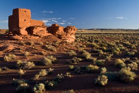
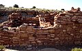
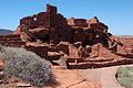
The dwelling's walls were constructed from thin, flat blocks of the local Moenkopi sandstone, giving the pueblos their distinct red color. Held together with mortar, many of the walls still stand. Each settlement was constructed as a single building, sometimes with scores of rooms. The largest settlement on monument territory is the Wupatki Pueblo, built around a natural rock outcrop. With more than 100 rooms, this pueblo is believed to be the region's tallest and largest structure for its time period. The monument also contains structures identified as a ball court, similar to those found in Mesoamerica and in the Hohokam sites of southern Arizona; this is the northernmost example of this kind of structure. This site also contains a geological blowhole,[9] from which wind escapes from a cave system. Other major sites are Wukoki and The Citadel.
Today, Wupatki appears empty and abandoned, but it is remembered and cared for. Although it is no longer physically occupied, Hopi believe the people who lived and died here remain as spiritual guardians. Stories of Wupatki are passed on among Hopi, Navajo, Zuni, and other Native American tribes in the region. Members of the Hopi Bear, Katsina, Lizard, Rattlesnake, Sand, Snow, and Water Clans return periodically to enrich their personal understanding of their clan history.[10]

Amidst what would seem a generally inhospitable area due to the lack of food and water sources, several artifacts have been located at the site from distant locations, implying that the people who inhabited Wupatki were involved in trade. During numerous excavations stretching back to the site' exploration in the mid-1800s,[11] items from as far as the Pacific and the Gulf Coasts have been located at the site, such as many different varieties of pottery and seashells.
- Wupatki Sites
-
 Wupatki Paronama
 -
 Wupatki Ball Court
 -
 Box Canyon
 -
 Wupatki Pueblo


Climate[edit]
Wupatki has a dry climate, classified by the Köppen climate classification system as a borderline semi-arid climate and arid climate (BSk/BWk). Wupatki has cold winters and hot summers.
Studies have been conducted to compare the climate of Wupatki in the 12th and 13th century, to the 20th century. The findings show that there has been very little change to the climate in the last 2,000 years.[12]
| Climate data for Wupatki National Monument, Arizona, 1991–2020 normals, extremes 1940–present | |||||||||||||
|---|---|---|---|---|---|---|---|---|---|---|---|---|---|
| Month | Jan | Feb | Mar | Apr | May | Jun | Jul | Aug | Sep | Oct | Nov | Dec | Year |
| Record high °F (°C) | 76 (24) |
77 (25) |
85 (29) |
92 (33) |
101 (38) |
107 (42) |
109 (43) |
106 (41) |
102 (39) |
93 (34) |
82 (28) |
72 (22) |
109 (43) |
| Mean maximum °F (°C) | 61.7 (16.5) |
67.7 (19.8) |
76.7 (24.8) |
84.7 (29.3) |
91.5 (33.1) |
101.3 (38.5) |
103.4 (39.7) |
99.7 (37.6) |
94.6 (34.8) |
85.9 (29.9) |
72.7 (22.6) |
62.1 (16.7) |
104.0 (40.0) |
| Mean daily maximum °F (°C) | 47.6 (8.7) |
54.5 (12.5) |
63.1 (17.3) |
70.5 (21.4) |
79.7 (26.5) |
91.5 (33.1) |
94.4 (34.7) |
91.2 (32.9) |
84.6 (29.2) |
72.5 (22.5) |
57.9 (14.4) |
45.9 (7.7) |
71.1 (21.7) |
| Daily mean °F (°C) | 36.8 (2.7) |
42.3 (5.7) |
49.8 (9.9) |
56.7 (13.7) |
65.7 (18.7) |
76.7 (24.8) |
80.8 (27.1) |
78.2 (25.7) |
71.2 (21.8) |
59.0 (15.0) |
45.8 (7.7) |
35.5 (1.9) |
58.2 (14.6) |
| Mean daily minimum °F (°C) | 26.0 (−3.3) |
30.1 (−1.1) |
36.4 (2.4) |
42.9 (6.1) |
51.6 (10.9) |
61.9 (16.6) |
67.1 (19.5) |
65.2 (18.4) |
57.7 (14.3) |
45.6 (7.6) |
33.7 (0.9) |
25.2 (−3.8) |
45.3 (7.4) |
| Mean minimum °F (°C) | 14.8 (−9.6) |
18.4 (−7.6) |
24.5 (−4.2) |
30.7 (−0.7) |
38.1 (3.4) |
49.8 (9.9) |
59.2 (15.1) |
57.8 (14.3) |
46.5 (8.1) |
32.3 (0.2) |
20.7 (−6.3) |
13.3 (−10.4) |
11.5 (−11.4) |
| Record low °F (°C) | −4 (−20) |
−2 (−19) |
10 (−12) |
14 (−10) |
20 (−7) |
30 (−1) |
41 (5) |
35 (2) |
33 (1) |
17 (−8) |
7 (−14) |
−5 (−21) |
−5 (−21) |
| Average precipitation inches (mm) | 0.68 (17) |
0.51 (13) |
0.60 (15) |
0.41 (10) |
0.40 (10) |
0.12 (3.0) |
1.59 (40) |
1.47 (37) |
0.99 (25) |
0.68 (17) |
0.48 (12) |
0.58 (15) |
8.51 (216) |
| Average snowfall inches (cm) | 0.5 (1.3) |
0.9 (2.3) |
0.4 (1.0) |
0.3 (0.76) |
0.0 (0.0) |
0.0 (0.0) |
0.0 (0.0) |
0.0 (0.0) |
0.0 (0.0) |
0.0 (0.0) |
0.4 (1.0) |
0.9 (2.3) |
3.4 (8.6) |
| Average precipitation days (≥ 0.01 inch) | 3.5 | 3.6 | 3.6 | 2.7 | 3.0 | 1.2 | 7.1 | 9.0 | 5.4 | 3.8 | 2.8 | 3.7 | 49.4 |
| Average snowy days (≥ 0.1 inch) | 0.7 | 0.6 | 0.2 | 0.2 | 0.0 | 0.0 | 0.0 | 0.0 | 0.0 | 0.0 | 0.2 | 0.7 | 2.6 |
| Source: NOAA[13][14] | |||||||||||||
See also[edit]
References[edit]
- ^ "Listing of acreage – December 31, 2011" (XLSX). Land Resource Division, National Park Service. Retrieved May 14, 2012. (National Park Service Acreage Reports)
- ^ . December 9, 1924 – via Wikisource.
- ^ "NPS Annual Recreation Visits Report". National Park Service. Retrieved April 11, 2019.
- ^ "History & Culture". Wupatki National Monument Arizona. National Park Service. January 4, 2018. Retrieved June 6, 2022.
- ^ "National Register Information System". National Register of Historic Places. National Park Service. March 13, 2009.
- ^ Catherine M. Cameron and Cherie L. Schieck (July 28, 1992). "National Register of Historic Places Registration: Wupatki National Monument".
- ^ Snow, Dean (2010). Archaeology of Native North America. Prentice Hall. p. 134. ISBN 978-0136156864.
- ^ Van Keuren, Scott; Neff, Hector; Agostini, Mark R. (December 2013). "Glaze-paints, technological knowledge, and ceramic specialization in the fourteenth-century Pueblo Southwest". Journal of Anthropological Archaeology. 32 (4): 675–690. doi:10.1016/j.jaa.2013.04.002. ISSN 0278-4165.
- ^ "The Breathing Earth: Wupatki Blowholes" (PDF). nps.gov. National Park Service U.S. Department of the Interior. Archived from the original (PDF) on October 29, 2015. Retrieved May 8, 2015.
- ^ "National Park Service". Wupatki National Monument. National Park Service. November 6, 2010.
- ^ "Welcome to Anthropology Labs". jan.ucc.nau.edu. Retrieved April 8, 2012.
- ^ Romme, William H.; Paul Whitefield, M.; Parker, Cynthia (February 2021). "Insights from recent fires into juniper savanna dynamics at Wupatki National Monument, Arizona, USA". Rangelands. 43 (1): 9–16. doi:10.1016/j.rala.2020.10.003. ISSN 0190-0528.
- ^ "NOWData - NOAA Online Weather Data". National Oceanic and Atmospheric Administration. Retrieved December 12, 2022.
- ^ "Summary of Monthly Normals 1991-2020". National Oceanic and Atmospheric Administration. Retrieved December 12, 2022.
External links[edit]
 Geographic data related to Wupatki National Monument at OpenStreetMap
- NPS: official Wupatki National Monument website
- American Southwest, National Park Service Discover Our Shared Heritage Travel Itinerary
- Anthropology Laboratories of Northern Arizona University
- U.S. Geological Survey Geographic Names Information System: Wupatki National Monument
- Historic American Buildings Survey (HABS) No. AZ-152-A, "Wupatki, Wupatki Ruin, U.S. Highway 89, Loop Road, Flagstaff vicinity, Coconino County, AZ"
- HABS No. AZ-152-B, "Wupatki, Wukoki Ruin, U.S. Highway 89, Loop Road, Flagstaff vicinity, Coconino County, AZ"
- HABS No. AZ-152-C, "Wupatki, Citadel Ruin, U.S. Highway 89, Loop Road, Flagstaff vicinity, Coconino County, AZ"
- HABS No. AZ-152-D, "Wupatki, Ball Court, U.S. Highway 89, Loop Road, Flagstaff vicinity, Coconino County, AZ"
 |  | ||
Municipalities and communities of Coconino County, Arizona, United States | ||
|---|---|---|
| Cities |  | |
| Towns | ||
| CDPs |
| |
| Populated places | ||
| Indian reservations | ||
| Ghost towns | ||
| Footnotes | ‡This populated place also has portions in an adjacent county or counties | |
| Archaeological cultures |
|
|---|---|
| Archaeological sites |
|
| Human remains | |
| Miscellaneous |
|
| |
| International | |
|---|---|
| National | |
- IUCN Category V
- National Park Service National Monuments in Arizona
- Archaeological sites in Arizona
- Parks in Coconino County, Arizona
- Puebloan buildings and structures
- Museums in Coconino County, Arizona
- Native American museums in Arizona
- Native American history of Arizona
- Archaeological sites on the National Register of Historic Places in Arizona
- National Register of Historic Places in Coconino County, Arizona
- Blowholes
- Former populated places in Arizona
- Historic American Buildings Survey in Arizona
- 1924 establishments in Arizona
- Protected areas established in 1924
- 11th century in North America
- Buildings and structures completed in the 11th century
- Ruins on the National Register of Historic Places
- Former populated places in Coconino County, Arizona
- Sinagua