
Alghero airport
| Aeroporto di Alghero Fertilia “Riviera del Corallo” |
|
|---|---|
.jpg)
|
|
| Characteristics | |
| ICAO code | LIEA |
| IATA code | AHO |
| Coordinates | |
| Height above MSL | 27 m (89 ft ) |
| Transport links | |
| Distance from the city center | 8 km north of Alghero , 25 km southwest of Sassari |
| Street |
|
| Local transport | Public bus to the city center of Alghero |
| Basic data | |
| opening | March 28, 1938 |
| operator | SO.GE.A.AL. |
| surface | 246 ha |
| Terminals | 1 |
| Passengers | 1,390,379 (2019) |
| Air freight | 2.9 t (2019) |
| Flight movements |
10,943 (2019) |
| Capacity ( PAX per year) |
2,000,000 |
| Start-and runway | |
| 02/20 | 3000 m × 45 m asphalt |
The Alghero Airport ( Italian Aeroporto di Alghero-Fertilia "Riviera del Corallo" ; IATA code : AHO , ICAO code : LIEA ) is an Italian commercial airport at Alghero in the northwest of Sardinia .
Location and transport links
The airport is located in the town of Fertilia, on the plain between the Coral Riviera in the south and the La Nurra region in the north. Alghero is around eight kilometers south, the provincial capital Sassari around 25 kilometers northeast of the airport.
There are bus routes to various cities on the island, some of which have connections in Sassari. The airport is to be connected to the Sassari – Alghero railway line .
history
In 1937 a landing stage for flying boats and handling facilities for the Ala Littoria was built in the bay of Porto Conte ( ⊙ ) west-northwest of Alghero . The latter connected Alghero with Ostia near Rome and Cagliari , at times also with Genoa and Barcelona . The flights had to be stopped a few years later due to the war.
The approximately five kilometers northeast of the Bay of Porto Conte situated Alghero-Fertilia Airport was built in 1938 as a military airfield in elliptical shape. Some buildings and hangars were erected in the west, and in 1943 the construction of a concrete runway began. The regular service between Rome and Alghero-Fertilia began in 1946. Later, the Alitalia subsidiary ATI in particular flew on this route . Charter traffic began in the mid-1950s, initially from Great Britain in particular . In the early 1960s, the airfield had a 2200 meter long runway and a hangar served as a check-in hall . A new terminal was built in 1968, and the runway was extended to 3000 meters in the mid-1970s. In 1974 the civil aviation administration took over the airport. The inauguration of today's terminal took place in 2003, the renovation of the runway in 2004. Further expansion is planned. In 2006 there were disputes between the cities of Alghero and Sassari, because Sassari insisted on the name “Sassari-Alghero Airport”, while in Alghero it was named after the local “Coral Riviera”. The airport company Sogeaal, founded in 1994, received a forty-year concession to operate the airport in 2007.
During the Cold War , the military intelligence services of Italy in particular used the military part of the airport to the west . They had a secret base about 30 kilometers south of the airport, at Capo Marrargiu . There was also a military flight school here .
In 1980 the airline Alitalia relocated its flight school, founded in Brindisi in 1963 , to Alghero. By 2003, budding were here airline pilots on training aircraft of the types Aermacchi SF-260 , Piaggio P.166 and Piper Cheyenne trained. Previously, four Aermacchi MB-326 had been used in Brindisi . The school was definitely closed in 2005.
Airlines and Destinations
There are scheduled flights to mainland Italy and connections with numerous European cities. The Irish airline Ryanair has a base in Alghero. Other important companies in Alghero are Alitalia and Air Italy . Especially in the summer months, charter traffic from Central and Northern Europe is picking up.
Traffic figures


| year | Passenger volume | Air freight ( tons ) (with airmail ) |
Flight movements |
|---|---|---|---|
| 2019 | 1,390,379 | 3 | 10,943 |
| 2018 | 1,365,129 | 2 | 10,798 |
| 2017 | 1,321,676 | 8th | 9,982 |
| 2016 | 1,346,403 | 10 | 10,514 |
| 2015 | 1,677,967 | 11 | 12,551 |
| 2014 | 1,639,374 | 39 | 13,804 |
| 2013 | 1,563,908 | 34 | 13,782 |
| 2012 | 1,518,870 | 1,637 | 14,296 |
| 2011 | 1,514,254 | 1,580 | 14,424 |
| 2010 | 1,388,217 | 1,447 | 14,218 |
| 2009 | 1,507,016 | 1,702 | 15,412 |
| 2008 | 1,380,762 | 1,308 | 14,554 |
| 2007 | 1,300,115 | 774 | 13,804 |
| 2006 | 1,070,491 | 609 | 11,028 |
| 2005 | 1,079,843 | 693 | 11,738 |
| 2004 | 998.811 | 1,200 | 11,390 |
| 2003 | 888.369 | 1,204 | 11,196 |
| 2002 | 804.937 | 1,440 | 11,366 |
| 2001 | 681.832 | 2.111 | 9,444 |
| 2000 | 664.330 | 1.963 | 10,550 |
photos
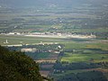
View from the west of the terminal, in the foreground the military part

Terminal airside


Others
The military part to the west of the airport site continues to serve as a forward base for the Italian air force and also to connect the base at Capo Marragiu (Torre Poglina), which is still used by intelligence services and special forces .
There are comparable airports in Sardinia in Cagliari and Olbia . The airports at Oristano ( Fenosu ) and Tortolì ( Tortolì-Arbatax ) were served by regional airlines, often only seasonally.
Web links
- Official homepage (English / French / Italian)
- aeroportodialghero.com (Engl./ital.)
- Airport guide Alghero at sardinien.com
Individual evidence
- ↑ a b c d e f Statistiche. In: assaeroporti.com. Assaeroporti , accessed April 17, 2020 (Italian).
- ↑ Distaccamento Aeroportuale Alghero on difesa.it
Alghero | Ancona | Aosta | Bari | Bergamo | Bologna | Bolzano | Brescia | Brindisi | Cagliari | Catania | Comiso | Crotone | Cuneo | Elba | Florence | Foggia | Forlì | Genoa | Lamezia Terme | Lampedusa | Milan Linate | Milan-Malpensa | Naples | Olbia | Palermo | Pantelleria | Parma | Perugia | Pescara | Pisa | Reggio Calabria | Rimini | Rome Ciampino | Rome Fiumicino | Salerno | Trapani | Treviso | Trieste | Turin | Venice | Verona