Albany County (New York)
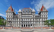
 Albany County Courthouse |
|
| administration | |
|---|---|
| US state : | new York |
| Administrative headquarters : | Albany |
| Foundation : | 1683 |
| Demographics | |
| Residents : | 304,204 (2010) |
| Population density : | 224.3 inhabitants / km 2 |
| geography | |
| Total area : | 1381 km² |
| Water surface : | 25 km² |
| map | |
| Website : www.albanycounty.com | |
Albany County is a county in the state of New York in the United States . At the 2010 census , the county had 304,204 people and a population density of 224.3 people per square kilometer. The county seat is Albany , which is also the capital of the state of New York.
geography
The county has an area of 1,381 square kilometers, of which 25 square kilometers are water.
history
The indigenous people
The Native American Indians of the Crown Colony of New York belonged predominantly to the Iroquois language family. The most influential tribes of this language family there consisted of the famous Six Nations , the Iroquois League, consisting of Oneida, Onondaga, Cayuga, Seneca, Mohawk and Tuscarora. The tribes of the Susquehanna, Erie, Hurons (Wyandot) etc. also belonged to this language family.
The Algonquin language family, whose most important tribes for the New York area consisted of the Delawars (Lenape), Mohegan and Shaghticoke , had little influence on further development except in Pennsylvania, Long Island, Maine and the Susquehanna River from Albany County and therefore play a subordinate role for us.
The Albany County was from the Mohawk Valley to the confluence of the Mohawk River in the Hudson River, the settlement area of the Mohawk (Kenyan Kehaka) and the rather small tribe of the Shaghticoke. These tribes also gave their names to the Mohawk River and its valley and the Shaghticoke settlement.
As far as hostilities against the European immigrants are concerned, it was the Mohawk in particular who gave the settlers a hard time, they were considered uncompromising warriors who could not be outdone in their cruelty. They were reluctant to be driven from their traditional hunting grounds and raids were the order of the day until the end of the War of Independence.
Nieuw Nederland
The Italian explorer Giovanni da Verrazano sailed into New York Bay as early as 1524.
However, colonization by the Europeans only began after the English navigator Henry Hudson, who sailed on behalf of the Netherlands, took possession of the area for them in 1609. In 1621 the province of Nieuw Nederland, in what is now the US state of New York, was founded by the Dutch. The Dutch West India Company founded the settlement of Fort Orange three years later in 1624, near present-day Albany, and New Amsterdam in 1626 on the southern tip of Manhattan Island. In order to promote the settlement, a charter was issued in 1629, which granted the settlements certain freedoms and privileges. The colony of Nieuw Nederland suffered from attacks by the Indians and internal mismanagement in the first few years, but eventually achieved a certain degree of calm and economic stability under Peter Stuyvesant, who was governor of the colony from 1647 to 1664.
new York
In 1664, under the reign of Charles II, the province was occupied by the English crown under the auspices of the James Duke of York, who later became King James II. After the successful campaign, the province was renamed New York in his honor. After the Peace of Breda in 1667, the Dutch gave up their claims and New York finally fell to the English crown. In 1683 Jacob was appointed lord protector of the province by his brother Charles II, and in 1684 Thomas Dongan was appointed as the first governor of the province. James declared New Jersey, which was originally part of the New Netherlands Colony, a colony in its own right and acquired the eastern part of the Long Islands from Connecticut.
After another, but only brief, occupation by the Dutch from 1673 to 1674, the colony came under British rule again. After James had ascended the English throne as King James II in 1685, he founded the Dominion of New England, in which New England, New York and New Jersey were combined.
When the people of New York learned of the king's overthrow in 1688, they rebelled and appointed Jacob Leisler their governor. After the power of the royal family was restored in 1691, Leisler was hanged for high treason; the people's representative body founded on his initiative was retained and involved in the government of the colony. In 1690 the settlement of Schenectady was destroyed in an attack by the French and Indians.
New York remained a theater of war in the battles against the French and their Indian allies in the decades that followed. During the war from 1754 to 1763, the French built an important base at Fort Ticonderoga on Lake Champlain and advanced south to Lake George. It was not until Lord Jeffrey Amherst succeeded in driving the French out of Ticonderoga and Crown Point in 1759 that New York was safe from further French attacks.
The peace of 1763 put an end to the French presence in this region and gave the starting signal for further penetration into the areas of the Indians in the Mohawk Valley and around the Great Lakes.
Albany
Along with New York, Suffolk, Kings, Queens, Richmond, Westchester, Orange, Ulster, Dutchess, Cornwall (today's Maine) and Dukes (today's Martha's Vineyard), Albany is one of the twelve founding counties of the province of New York.
According to the definition at that time, Albany County included: the city of Albany, the colony of Renslaerwyck, the settlement of Schonecteda, all villages, settlements and Christian outposts on the east side of the Hudson River, from the Roelof Jansen's Creeke and in the west all areas of Sawyer's Creeke to Sarraghtoga.
From the 60s of the 18th century, the name Albany became more and more common as a name for the entire area of New York located on the upper reaches of the Hudson. The exact definition of the boundaries became the subject of bitter discussions between the individual counties, which is also reflected in the contemporary maps, which differ greatly in their boundaries.
This state of affairs was only ended by the so-called Sauthier Map (named after the topographer Claude Joseph Sauthier), published in 1776, because this map, commissioned by Governor William Tryon, finally determined the boundaries of the individual counties.
In 1776, Albany County consisted of 17 so-called Districts with a total population of 42,706 inhabitants.
- The City of Albany
- Manor of Ranselear District
- Manor of Livingston District
- Claverach District
- Schohary District
- Schonectady District
- Catskill & Coxhachy District
- Kinderhook District
- Saratoga District
- Schachtakook District
- Hosack District
- German Camp District
- Great Inboght District
- Half Moon District
- Cambridge District
- Kings District
- Ballstown District
The Albany County Militia
The Albany County Militia fought on the side of the Continental Army in the American Revolutionary War .
It consisted of 17 regiments and an independent company. Each of these regiments consisted of 200–500 men and was divided into four to seven companies.
The regiments were divided into districts or regions, and were identified by the name of the commander in addition to the regiment number, for example Wempel's 2nd Regiment of the Albany County Militia.
The regiments of the Albany County Militia
| regiment | District | commander |
|---|---|---|
| 1st | City of Albany | Col. Abraham Cuyler |
| 2nd | Schenectady District | Col. Abraham Wemple |
| 3rd | 1st Rensselerwyck District Battalion | Col. Philip P. Schyler |
| 4th | 2nd Rensselerwyck District Battalion | Col. Killian Van Rensselaer |
| 5th | 3rd Rensselerwyck District Battalion | Col. Gerrit G. van den Bergh |
| 6th | 4th Rensselerwyck District Battalion | Col. Stephen John Schuyler |
| 7th | Kinderhook District | Col. Abraham J. Van Alstine |
| 8th | 1st Claverack District Battalion | Col. Robert Van Rensselaer |
| 9th | 2nd Claverack District Battalion | Col. Peter Van Ness |
| 10th | Manor Of Livingston | Col. Morris Graham |
| 11th | Coxsackie and Groote Imbockt | Col. Jacobus Van Schoonhoven |
| 12th | Half Moon and Ballston Districts | Col. Anthony Van Bergen |
| 13th | Saratoga District | Col John McCrea |
| 14th | Hoosack and Schaghtecooke | Col. John Knickerbacker |
| 15th | United Districts of Schoharie and Duanesburgh | Col. Peter Vroman |
| 16th | Cambridge District | Col. John Blair |
| 17th | Kings District (from the Canaan / Chatham area, now Columbia County) | Col. William B. Whiting |
| Independent company | Capt. Petrus Van Gaasbeck | |
Historical places

Ten locations have National Historic Landmark status . 208 buildings and sites in the county are listed in the National Register of Historic Places (as of February 17, 2018).
Cities and towns
Individual evidence
- ↑ GNIS-ID: 974099. Retrieved on February 22, 2011 (English).
- ↑ Listing of National Historic Landmarks by State: New York . National Park Service , accessed February 17, 2018.
- ↑ Search mask database in the National Register Information System. National Park Service , accessed February 17, 2018.
Web links
Coordinates: 42 ° 36 ′ N , 73 ° 58 ′ W

