
Schollach (Lower Austria)
|
Schollach
|
||
|---|---|---|
| coat of arms | Austria map | |
 |
|
|
| Basic data | ||
| Country: | Austria | |
| State : | Lower Austria | |
| Political District : | Melk | |
| License plate : | ME | |
| Main town : | Groß-Schollach | |
| Surface: | 19.7 km² | |
| Coordinates : | 48 ° 11 ′ N , 15 ° 21 ′ E | |
| Height : | 241 m above sea level A. | |
| Residents : | 1,017 (January 1, 2020) | |
| Population density : | 52 inhabitants per km² | |
| Postal code : | 3382 | |
| Area code : | 02754 | |
| Community code : | 3 15 43 | |
| NUTS region | AT121 | |
| Address of the municipal administration: |
Groß-Schollach 53 3382 Schollach |
|
| Website: | ||
| politics | ||
| Mayor : | Walter Handl ( ÖVP ) | |
|
Municipal Council : ( 2015 ) (15 members) |
||
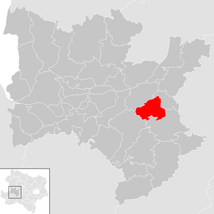
| Location of Schollach in the Melk district | ||
  |
||
| Source: Municipal data from Statistics Austria | ||

Schollach is a municipality with 1017 inhabitants (as of January 1, 2020) in the Melk district in Lower Austria .
geography
Schollach is located in the Mostviertel in Lower Austria. The area of the municipality covers 19.67 square kilometers. 37.23 percent of the area is forested.
Community structure
The municipality includes the following seven localities (population in brackets as of January 1, 2020):
- Anzendorf (136)
- Gross-Schollach (234)
- Klein-Schollach (31)
- Merkendorf (81)
- Roggendorf (312)
- Schallaburg (137) including Kleinberg and Reithen
- Steinparz (86)
The community consists of the cadastral communities Anzendorf, Merkendorf, Roggendorf, Schallaburg and Schollach.
Neighboring communities
| Melk | Loosdorf | |
.svg)
|
||
| St. Leonhard am Forst | Hürm |
history
In ancient times, the area was part of the Noricum province .
- Lower Austria. Municipal structure improvement : In 1970 the municipalities were amalgamated with the former municipality of Anzenbach at the foot of the Schallaburg .
Population development
According to the results of the 2001 census, there were 899 inhabitants. In 1991 the community had 846 inhabitants, in 1981 801 and in 1971 817 inhabitants.
politics
The municipal council has 15 members.
- With the municipal council elections in Lower Austria in 1990, the municipal council had the following distribution: 11 ÖVP and 4 SPÖ.
- With the municipal council elections in Lower Austria in 1995, the municipal council had the following distribution: 10 ÖVP and 5 SPÖ.
- With the municipal council elections in Lower Austria in 2000, the municipal council had the following distribution: 10 ÖVP and 5 SPÖ.
- With the municipal council elections in Lower Austria in 2005 , the municipal council had the following distribution: 9 ÖVP and 6 SPÖ.
- With the municipal elections in Lower Austria in 2010 , the municipal council had the following distribution: 10 ÖVP, 4 SPÖ and 1 FPÖ.
- With the municipal elections in Lower Austria in 2015 , the municipal council has the following distribution: 8 ÖVP, 5 SPÖ and 2 FPÖ.
- mayor
- until 2015 Norbert Gleiss (ÖVP)
- since 2015 Walter Handl (ÖVP)
Culture and sights
- Schallaburg : Renaissance castle, which houses the exhibition center of the province of Lower Austria, in which major exhibitions take place every year.
- Pilgrimage church in Steinparz
economy
In 2001 there were 30 non-agricultural workplaces, and according to the 1999 survey there were 66 in agriculture and forestry. According to the 2001 census, the number of people in employment at home was 426. In 2001, the employment rate was 48.72 percent.
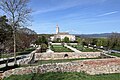
The Schallaburg

The “Försterstöckl” on the Schallaburg

Arcade courtyard in the Schallaburg
.JPG)


Web links
- https://www.schollach.at
- 31543 - Schollach (Lower Austria). Community data, Statistics Austria .
- Entry about Sichtenberg castle ruins on Lower Austria castles online - Institute for Reality Studies of the Middle Ages and Early Modern Times, University of Salzburg
Individual evidence
- ↑ Statistics Austria: Population on January 1st, 2020 by locality (area status on January 1st, 2020) , ( CSV )
- ^ Community of Schollach: Anzenbach ; accessed on April 15, 2018
- ^ Result of the local council election 1995 in Schollach. Office of the Lower Austrian State Government, March 30, 2000, accessed on October 25, 2019 .
- ^ Election result of the municipal council election 2000 in Schollach. Office of the Lower Austrian State Government, February 4, 2005, accessed on October 25, 2019 .
- ^ Election result of the local council election 2005 in Schollach. Office of the Lower Austrian State Government, March 4, 2005, accessed on October 25, 2019 .
- ^ Election result of the local council election 2010 in Schollach. Office of the Lower Austrian State Government, October 8, 2010, accessed on October 25, 2019 .
- ^ Election result of the 2015 municipal council election in Schollach. Office of the Lower Austrian State Government, December 1, 2015, accessed on October 25, 2019 .

Artstetten-Pöbring | Mountain country | Bischofstetten | Blind market | Dorfstetten | Dunkelsteinerwald | Emmersdorf an der Donau | Erlauf | Golling an der Erlauf | Court Office Priel | Hürm | Kilb | Kirnberg an der Mank | Klein-Pöchlarn | Curved walnut | Body | Loosdorf | Deficiency | Marbach an der Donau | Maria Taferl | Melk | Münichreith-Laimbach | Neumarkt an der Ybbs | Nöchling | Persenbeug-Gottsdorf | Petzenkirchen | Pöchlarn | Pöggstall | Raxendorf | Ruprechtshofen | Schollach | Schönbühel-Aggsbach | St. Leonhard am Forst | St. Martin-Karlsbach | St. Oswald | Texingtal | Expanses | Ybbs on the Danube | Yspertal | Zelking-Matzleinsdorf
Cadastral communities: Anzendorf | Merkendorf | Roggendorf | Schallaburg | Schollach
Locations: Anzendorf | Groß-Schollach | Klein-Schollach | Merkendorf | Roggendorf | Schallaburg | Steinparz
Villages: Anzendorf | Groß-Schollach | Klein-Schollach | Merkendorf | Roggendorf | Steinparz Rotte: Kleinberg | Reithen | Schallaburg Other locations: Sichtenberg ruins | Schallaburg Castle