Auholz (Hilpoltstein)
|
Auholz
City of Hilpoltstein
Coordinates: 49 ° 12 ′ 29 ″ N , 11 ° 12 ′ 57 ″ E
|
|
|---|---|
| Height : | 404 m |
| Residents : | 5 (1987) |
| Postal code : | 91161 |
| Area code : | 09174 |
|
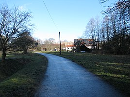
Auholz, seen from the Lochmühle
|
|
Auholz is a district of Hilpoltstein in the Middle Franconian district of Roth in Bavaria .
location
The wasteland is surrounded by fields, north of the Espan trench at 404 meters above sea level, northeast of the community center. A forest area of the same name spreads south of Auholz, which rises to 409 meters above sea level and then falls back down to Espangraben.
The local corridor is 44 hectares .
history
Auholz is not mentioned in the description of the property in Nuremberg from 1544, when the Palatinate-Neuburgian office of Hilpoltstein was pledged to the imperial city , and must therefore only have arisen afterwards. The Auholz is mentioned as a forest area in the description of the property: Here, in “des Bredenwinder's own”, “the von Altenhofen ” drove the cattle. The "Auholtz" is also mentioned as a forest area in a description of the Hilpoltstein office from 1604. It will have given its name to the later founding of the wasteland.
Towards the end of the Old Kingdom , around 1800, Auholz was a wasteland of a free farm in the Hilpoltstein nursing office, which exercised high jurisdiction .
In the new Kingdom of Bavaria (1806) the wasteland Auholz became part of the municipality of Heuberg , to which in 1867, apart from Heuberg and Auholz, Altenhofen , the Aumühle , also called lattice mill, the Lochmühle and the hamlet "Stöckgut" (= general cargo ) belonged. In 1875 five head of cattle were kept in Auholz. Around 1904 the wasteland was uninhabited. In 1937 the farm was given four residents, eleven around 1950 and five in 1987.
As part of the regional reform in Bavaria , the municipality of Heuberg (Heuberg, Altenhofen, Auholz, Aumühle and Lochmühle) was incorporated into Hilpoltstein on January 1, 1972.
Population development
- 1818: 7 (1 "fireplace" = house, 2 families)
- 1831: 13 (2 houses)
- 1836: 4 (1 house)
- 1867: 7 (4 buildings)
- 1875: 5 (5 buildings)
- 1904: 0 (1 residential building)
- 1937: 4
- 1950: 11
- 1961: 9 (1 residential building)
- 1973: 11
- 1987: 5 (1 residential building, 1 apartment)
traffic
State road 2220 passes in the south of the desert and goes from the town hall in the direction of Mörlach and on to Freystadt . From here a communal road branches off towards the north, from which after 500 meters a junction leads over the Lochmühle near Heuberg to Auholz and ends there.
literature
- Wolfgang Wiessner: Historical Atlas of Bavaria. Part Franconia, series I, issue 24: Hilpoltstein. Munich 1978
Individual evidence
- ↑ Wiessner, p. 27
- ↑ Carl Siegert: History of the rule, castle and town Hilpoltstein, their rulers and residents. In: Negotiations of the historical association of Upper Palatinate and Regensburg 20 (1861), p. 211
- ^ Günter Frank and Georg Paulus: Edition of Christoph Vogels Descriptions of the Palatinate-Neuburgic Nursing Office (1598-1604), Part 18: Nursing Office Hilpoltstein In: p. 13 ( page no longer available , search in web archives ) Info: The link was automatically created as marked defective. Please check the link according to the instructions and then remove this notice.
- ^ Wiessner, p. 206
- ↑ Kgl. Statistical Bureau in Munich (edit.): Complete list of localities of the Kingdom of Bavaria , Munich 1876, column 888
- ^ Wilhelm Volkert (ed.): Handbook of Bavarian offices, communities and courts 1799–1980 . CH Beck, Munich 1983, ISBN 3-406-09669-7 , p. 483 .
- ↑ Alphabetical index of all the localities contained in the Rezatkreise ... , Ansbach 1818, p. 6
- ^ Joseph Anton Eisenmann and Karl Friedrich Hohn: Topo-geographical-statistical lexicon from the Kingdom of Bavaria. 1st volume. Erlangen: Joh. Jac. Palm and Ernst Enke 1831, p. 91
- ↑ Th. D. Popp: Register of the Bissthumes Eichstätt . Eichstätt: Ph. Brönner 1836, p. 82 (No. 73)
- ↑ J. Heyberger and others: Topographical-statistical manual of the Kingdom of Bavaria together with an alphabetical local dictionary. Munich 1867, column 713
- ↑ Kgl. Statistical Bureau in Munich (edit.): Complete list of localities of the Kingdom of Bavaria , Munich 1876, column 888
- ^ Locations directory of the Kingdom of Bavaria with an alphabetical register of locations , Munich 1904, column 1218
- ^ Franz Xaver Buchner: The diocese of Eichstätt. Volume I: Eichstätt 1937, p. 507
- ^ Wiessner, p. 252
- ^ Official register of places for Bavaria. Territorial status on October 1, 1964 with statistical information from the 1961 census , Munich 1964, column 795
- ^ Wiessner, p. 262
- ↑ Official directory for Bavaria, territorial status: May 25, 1987 , Munich 1991, p. 348

