Unterrödel
|
Unterrödel
City of Hilpoltstein
Coordinates: 49 ° 9 '32 " N , 11 ° 10' 22" E
|
||
|---|---|---|
| Height : | 380 m above sea level NHN | |
| Area : | 4.58 km² | |
| Residents : | 285 | |
| Population density : | 62 inhabitants / km² | |
| Incorporation : | January 1, 1972 | |
| Postal code : | 91161 | |
| Area code : | 09177 | |
|
Location of Unterrödel in Bavaria |
||
|
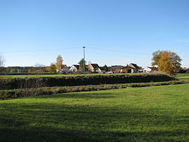
Place view
|
||
Unterrödel is a district of the town of Hilpoltstein in the Central Franconian district of Roth in Bavaria .
location
The village is located about five kilometers southwest of the old town of Hilpoltstein on both sides of the Roth , a right tributary of the Rednitz , at 380 meters above sea level .
The area was around 432 hectares at the beginning of the 19th century and 458 hectares at the beginning of the 20th century .
history
"Rota" near "Tyufenbach" first appeared in a document in 1129, as an episcopal-Eichstättischer property. In 1384 Friedrich II. Von Heideck acquired some farms near Rödel. 1480 Johann was years Dorfer to cell when it operates collection of Walburgiskapelle to cell to the parish from the Eichstätter Domkapitel purchased Kleinzehent of "Niederrödl", including the Nußhacken- Rothen- and Weihermühle belonged to the priest to Zell. The village, which has belonged to the newly established Palatinate-Neuburg territory since 1505 and there to the Heideck maintenance office, was captured by the Reformation with the parish of Zell in the course of pledging the Heideck maintenance office to the imperial city of Nuremberg in 1542 . In 1627, due to the Counter Reformation , Zell became a Catholic parish again, so that Unterrödel also returned to the old faith. During the Thirty Years' War the village was destroyed, so that in 1642 it was said that everything “collapsed and nobody was there”. Exiles from Austria may also have been involved in the development work.
Towards the end of the Old Kingdom , around 1800, Unterrödel consisted of 17 subject properties and a shepherd's house; an estate was a tavern. Eight subjects belonged to the Heideck office, four to the Kreßische Eigenherrschaft Nuremberg, three to the Eichstätt caste office in Obermässing , two to the electoral-Baier office of Sulzbuerg and one to the alms office in Nuremberg. The Heideck nursing office exercised high jurisdiction .
In the new Kingdom of Bavaria (1806) a tax district Unterrödel was formed, to which the Rothenmühle and Weihersmühle, then Tiefenbach with Lochmühle and Oberrödel with Mühle, Selingstadt and also Zell with its castle belonged. The community Unterrödel (Unterrödel with the Rothen- and Weihersmühle) had 121 inhabitants in 1861, 17 of them in the two mills, in 1900 97 inhabitants, 17 of them in the two mills, in 1961 168 inhabitants, 18 of them in the mills.
In 1875 nine horses, 108 cattle, 1 sheep, 26 pigs and 1 goat were kept in the community, four of them horses and 83 cattle in the village itself. In 1904, according to official census, the community's livestock consisted of five horses, 104 cattle, 71 pigs and two goats; In other places too, pig farming had grown rapidly in the last quarter of the 19th century.
As part of the municipal reform , the municipality of Unterrödel, i.e. the village itself and the two mills Rothen- and Weihersmühle, was incorporated into the town of Hilpoltstein on January 1, 1972.
In 1999 the Unterrödel volunteer fire brigade built a Florian chapel. With her there is a Jurassic stone with a memorial plaque for the fire brigade comrades who died in the two world wars.
Residents
(only the village of Unterrödel, without the wastelands Rothenmühle and Weihersmühle)
- 1818: 95 (21 "fire places" = property, 24 families)
- 1836: 92 (18 properties)
- 1861: 104 (42 buildings)
- 1875: 99 (33 buildings, 43 residential buildings)
- 1904: 80 (18 residential buildings)
- 1937: 92 (including 4 Protestants, parish to Eysölden)
- 1950: 125 (21 residential buildings)
- 1961: 150 (29 residential buildings)
- 1970: 194 (37 residential buildings)
- 1987: 253 (71 residential buildings, 85 apartments)
- around 2015: 285
Architectural monuments
A coat of arms relief on the Unterrödel A 6 property and the sandstone door walls of the Unterrödel C 6 property, both from the early 19th century, are considered architectural monuments.
traffic
Unterrödel is located between Hilpoltstein and Oberrödel on the state road St 2225, from which the state road St 2226 branches off in the village, leading to Heideck. A local connecting road runs parallel to the Roth in a north-westerly direction to the Fuchsmühle , in a south-easterly direction to the Weihersmühle. Another local connection road also leads southeast to Lochmühle near Oberrödel . From Unterrödel E you reach the Hilpoltsteiner district Rothenmühle after 100 meters.
societies
- Unterrödel volunteer fire department
- Bulldog friends Unterrödel-Oberrödel-Tiefenbach
- DJK Zell, Ober- u. Unterrödel e. V.
literature
- Wolfgang Wiessner: Historical Atlas of Bavaria. Part Franconia, series I, issue 24: Hilpoltstein. Munich 1978
- Franz Xaver Buchner: The Diocese of Eichstätt, Volume II: Eichstätt 1938
Web links
Individual evidence
- ↑ Wiessner, p. 37
- ↑ a b c d K. Bayer. Statistical Bureau (Ed.): Directory of localities of the Kingdom of Bavaria, with alphabetical register of places . LXV. Issue of the contributions to the statistics of the Kingdom of Bavaria. Munich 1904, Section II, Sp. 1222 ( digitized version ).
- ↑ Pastoral Journal of the Diocese of Eichstätt, No. 48 of December 1, 1860, p. 208
- ↑ Wiessner, p. 107
- ↑ Buchner II, p. 813
- ↑ Buchner II, p. 813 f.
- ↑ Wiessner, p. 180
- ^ Wiessner, p. 236
- ^ Wiessner, p. 258
- ↑ a b Joseph Heyberger, Chr. Schmitt, v. Wachter: Topographical-statistical manual of the Kingdom of Bavaria with an alphabetical local dictionary . In: K. Bayer. Statistical Bureau (Ed.): Bavaria. Regional and folklore of the Kingdom of Bavaria . tape 5 . Literary and artistic establishment of the JG Cotta'schen Buchhandlung, Munich 1867, Sp. 715 , urn : nbn: de: bvb: 12-bsb10374496-4 ( digitized version ).
- ↑ a b Bavarian State Statistical Office (ed.): Official city directory for Bavaria, territorial status on October 1, 1964 with statistical information from the 1961 census . Issue 260 of the articles on Bavaria's statistics. Munich 1964, DNB 453660959 , Section II, Sp. 798 ( digitized version ).
- ↑ a b Kgl. Statistical Bureau (ed.): Complete list of localities of the Kingdom of Bavaria. According to districts, administrative districts, court districts and municipalities, including parish, school and post office affiliation ... with an alphabetical general register containing the population according to the results of the census of December 1, 1875 . Adolf Ackermann, Munich 1877, 2nd section (population figures from 1871, cattle figures from 1873), Sp. 892 , urn : nbn: de: bvb: 12-bsb00052489-4 ( digitized ).
- ↑ hilpoltstein.de
- ↑ Alphabetical index of all the localities contained in the Rezatkkreis according to its constitution by the newest organization: with indication of a. the tax districts, b. Judicial Districts, c. Rent offices in which they are located, then several other statistical notes . Ansbach 1818, p. 96 ( digitized version ).
- ↑ Th. D. Popp: Register of the Bissthumes Eichstätt . Eichstätt: Ph. Brönner 1836, p. 165 (No. 199)
- ↑ Buchner, p. 818
- ^ Wiessner, p. 258
- ^ Bavarian State Statistical Office (ed.): Official place directory for Bavaria . Issue 335 of the articles on Bavaria's statistics. Munich 1973, DNB 740801384 , p. 180 ( digitized version ).
- ↑ Bavarian State Office for Statistics and Data Processing (Ed.): Official local directory for Bavaria, territorial status: May 25, 1987 . Issue 450 of the articles on Bavaria's statistics. Munich November 1991, DNB 94240937X , p. 348 ( digitized version ).
- ↑ hilpoltstein.de


