Altenhofen (Hilpoltstein)
|
Altenhofen
City of Hilpoltstein
Coordinates: 49 ° 11 ′ 54 ″ N , 11 ° 12 ′ 45 ″ E
|
|
|---|---|
| Height : | 381 m |
| Residents : | 91 (1987) |
| Postal code : | 91161 |
| Area code : | 09174 |
|
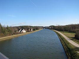
Altenhofen on the Main-Danube Canal, in the background the Hilpoltstein lock
|
|
Altenhofen is a district of Hilpoltstein in the Middle Franconian district of Roth in Bavaria .
location
The village is surrounded by fields, directly on the Main-Danube Canal at 381 meters above sea level northeast of the municipality.
The local corridor is 121 hectares .
history
In the Middle Ages, the place belonged to the domain of the imperial ministerial lords of (Hilpolt-) Stein . Altenhofen is first mentioned in a document in 1314, when Adelheid von Niedersulzbürg , an aunt of Hiltpolt von Stein, ceded ownership of the Altenhofen mill to the Cistercian monastery Seligenporten . As 1322 Hiltpolt stone his bailiwick rights over the rectory of "Heuberch" (= Heuberg gave the monastery), he received back the mill. Finally, in 1343 Hilpolt donated half a tenth of Altenhofen to the nuns at Seligenporten.
With the extinction of the Lords of Stein with Hilpolt IV on July 20, 1385, their area was first ruled jointly by the Bavarian dukes in 1386, until it fell to Duke Stefan during the fraternal division of Ingolstadt in 1392.
After the Landshut War of Succession , the land around Hilpoltstein and thus Altenhofen was incorporated into the new territory of the "Young Palatinate" in 1505 , which was given to Count Palatine Ottheinrich . The village was now under the Palatinate-Neuburgic office of Hilpoltstein. The heavily indebted Count Palatine Ottheinrich pledged the office and with it Altenhofen in 1542 for 36 years to the free imperial city of Nuremberg . With a decree of June 22, 1542, she introduced the Reformation in the Hilpoltstein office and thus also in Altenhofen. In 1544 Nuremberg had a book about the town and country of Hilpoltstein drawn up, in which Altenhofen is described as follows: “A farm is divided into two parts and a crew, one estate divided into three quarters, the other one quarter, with the upper and lower Mühl, then the Lochmühl, above this, the Loemühl was gone before times, but before human memory. Belonging to the rule of stone with all authority; what was above the water, the parish of Häberg (= Heuberg); the von Altenhofen had the cattle drive among others in the Auholz , the Bredenwinders own. "
In 1578 the office of Pfalz-Neuburg was redeemed. Since Pfalz-Neuburg had also become Protestant under Ottheinrich in 1542, the office and thus Altenhofen remained Protestant until 1627 when the Count Palatine Wolfgang Wilhelm, who had returned to the old faith, started the Counter-Reformation .
Towards the end of the Old Kingdom , around 1800, Altenhofen was a village of eight subject properties, including a mill (the Aumühle), all of which belonged to the Hilpoltstein formerly Palatinate-Neuburg, now electoral-Bavarian rent office. The keeper of Hilpoltstein exercised the high jurisdiction .
In the new Kingdom of Bavaria (1806) a tax district Heuberg was formed. After the community was formed in 1820, the following places belonged to the community of Heuberg:
- Heuberg,
- Altenhofen,
- the wasteland of Aumühle ,
- the Lochmühle , which was uninhabited at the time ,
- the Grashof (later part of the Göggelsbuch community ),
- the boys mill ,
- the Kronmühle (later part of the municipality of Birkach ),
- the loosing mill ,
- the village of Polsdorf (later part of the municipality of Birkach),
- the Seitzenmühle ,
- the Stephansmühle and
- the hamlet of general cargo , created after 1544 (1717: “Stickhof”; 1798: “Stuck-Guth”).
In 1867 only half of these settlements belonged to the municipality of Heuberg, namely Heuberg itself, Altenhofen, the desert areas of Auholz, Aumühle and Lochmühle and the hamlet of "Stöckgut". 58 people lived in Altenhofen, including - as noted in the sources - four Protestants who were parish in Eckersmühlen, while the Catholics belonged to the parish of Heideck. The children went to school in Heuberg. An official register from 1875 provides information about the livestock: In the municipality of Heuberg there were eleven horses, 220 cattle, 50 pigs and nine goats, in Altenhofen alone there were eight horses and 49 cattle.
In 1961, the community of Heuberg had a total of 246 inhabitants in 45 residential buildings in its now five locations (as early as 1937) Heuberg, Altenhofen, Auholz, Aumühle and Lochmühle; 77 people lived in Altenhofen in eleven residential buildings - two more than in 1950. In the 1980s, the village grew rapidly.
As part of the regional reform in Bavaria , the municipality of Heuberg (Heuberg, Altenhofen, Auholz, Aumühle and Lochmühle) was incorporated into Hilpoltstein on January 1, 1972.
In 2014, the 120 meter long Hilpoltstein-Altenhofen canal bridge from 1981 had to be renovated.
Population and building development
(Altenhofen without the Aumühle)
- 1836: 48 (eight houses)
- 1861: 58 (including four Protestants) (14 buildings)
- 1871: 43 (24 buildings)
- 1900: 41 (ten residential buildings)
- 1937: 49 (including six Protestants)
- 1950: 71 (nine residential buildings)
- 1961: 77 (eleven residential buildings)
- 1973: 68
- 1987: 91 (24 residential buildings, 30 apartments)
- later: 117
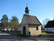
Catholic Chapel of St. Mary and St. Martin
The chapel was "rebuilt" in 1785, donated by the landlord Martin Hofmann, as an inscription in the gable shows. The plastered building has a gable roof with a ridge turret and is considered an architectural monument, see list of architectural monuments in Altenhofen . The altarpiece shows the coronation of Mary; on the antependium , St. Martin his coat.
traffic
In the north of the village, the state road 2220 passes, which goes from the town hall in the direction of Mörlach and on to Freystadt and crosses the Main-Danube Canal near the village. Two branches lead from here at a distance of 1.5 km to Altenhofen.
literature
- Wolfgang Wiessner: Hilpoltstein . In: Commission for Bavarian State History at the Bavarian Academy of Sciences (Hrsg.): Historical Atlas of Bavaria . Part Franconia, Series I, Issue 24. Munich 1978, ISBN 3-7696-9908-4 ( digitized version ).
- Carl Siegert: History of the rulership, castle and town of Hilpoltstein, its rulers and residents. In: Negotiations of the historical association of Upper Palatinate and Regensburg 20 (1861)
- Franz Xaver Buchner: The diocese of Eichstätt. Volume I: Eichstätt 1937
Web links
- Altenhofen on the website of the city of Hilpoltstein
- Forest and wood educational trail between Altenhofen and Mörlach
- Hilpoltstein 3 cycle path to fraenkisches-seenland.de
Individual evidence
- ^ Wolfgang Wiessner: Hilpoltstein . In: Commission for Bavarian State History at the Bavarian Academy of Sciences (Hrsg.): Historical Atlas of Bavaria . Part Franconia, Series I, Issue 24. Munich 1978, ISBN 3-7696-9908-4 , p. 26 ( digitized version ).
- ^ Wolfgang Wiessner: Hilpoltstein . In: Commission for Bavarian State History at the Bavarian Academy of Sciences (Hrsg.): Historical Atlas of Bavaria . Part Franconia, Series I, Issue 24. Munich 1978, ISBN 3-7696-9908-4 , p. 66 ( digitized version ).
- ^ Wolfgang Wiessner: Hilpoltstein . In: Commission for Bavarian State History at the Bavarian Academy of Sciences (Hrsg.): Historical Atlas of Bavaria . Part Franconia, Series I, Issue 24. Munich 1978, ISBN 3-7696-9908-4 , p. 73 ( digitized version ).
- ↑ Siegert, p. 196 f.
- ^ Siegert, p. 201
- ^ Wolfgang Wiessner: Hilpoltstein . In: Commission for Bavarian State History at the Bavarian Academy of Sciences (Hrsg.): Historical Atlas of Bavaria . Part Franconia, Series I, Issue 24. Munich 1978, ISBN 3-7696-9908-4 , p. 178 ( digitized version ).
- ^ Siegert, p. 211
- ^ Wolfgang Wiessner: Hilpoltstein . In: Commission for Bavarian State History at the Bavarian Academy of Sciences (Hrsg.): Historical Atlas of Bavaria . Part Franconia, Series I, Issue 24. Munich 1978, ISBN 3-7696-9908-4 , p. 179 ( digitized version ).
- ^ Wolfgang Wiessner: Hilpoltstein . In: Commission for Bavarian State History at the Bavarian Academy of Sciences (Hrsg.): Historical Atlas of Bavaria . Part Franconia, Series I, Issue 24. Munich 1978, ISBN 3-7696-9908-4 , p. 206 ( digitized version ).
- ↑ a b Wolfgang Wiessner: Hilpoltstein . In: Commission for Bavarian State History at the Bavarian Academy of Sciences (Hrsg.): Historical Atlas of Bavaria . Part Franconia, Series I, Issue 24. Munich 1978, ISBN 3-7696-9908-4 , p. 252 ( digitized version ).
- ↑ a b Joseph Heyberger, Chr. Schmitt, v. Wachter: Topographical-statistical manual of the Kingdom of Bavaria with an alphabetical local dictionary . In: K. Bayer. Statistical Bureau (Ed.): Bavaria. Regional and folklore of the Kingdom of Bavaria . tape 5 . Literary and artistic establishment of the JG Cotta'schen Buchhandlung, Munich 1867, Sp. 713 , urn : nbn: de: bvb: 12-bsb10374496-4 ( digitized version ).
- ↑ a b Kgl. Statistical Bureau (ed.): Complete list of localities of the Kingdom of Bavaria. According to districts, administrative districts, court districts and municipalities, including parish, school and post office affiliation ... with an alphabetical general register containing the population according to the results of the census of December 1, 1875 . Adolf Ackermann, Munich 1877, 2nd section (population figures from 1871, cattle figures from 1873), Sp. 888 , urn : nbn: de: bvb: 12-bsb00052489-4 ( digital copy ).
- ↑ Buchner I, p. 507
- ↑ a b Bavarian State Statistical Office (ed.): Official city directory for Bavaria, territorial status on October 1, 1964 with statistical information from the 1961 census . Issue 260 of the articles on Bavaria's statistics. Munich 1964, DNB 453660959 , Section II, Sp. 795 ( digitized version ).
- ^ Wilhelm Volkert (ed.): Handbook of Bavarian offices, communities and courts 1799–1980 . CH Beck, Munich 1983, ISBN 3-406-09669-7 , p. 483 .
- ↑ Project information of the Staatl. Building authority Nuremberg ( Memento of the original from January 25, 2016 in the Internet Archive ) Info: The archive link was inserted automatically and has not yet been checked. Please check the original and archive link according to the instructions and then remove this notice.
- ↑ Final spurt at the canal bridge . In: Hilpoltsteiner Kurier from December 3, 2014
- ↑ Th. D. Popp: Register of the Bissthumes Eichstätt . Eichstätt: Ph. Brönner 1836, p. 82 (No. 73)
- ↑ K. Bayer. Statistical Bureau (Ed.): Directory of localities of the Kingdom of Bavaria, with alphabetical register of places . LXV. Issue of the contributions to the statistics of the Kingdom of Bavaria. Munich 1904, Section II, Sp. 1218 ( digitized version ).
- ↑ Buchner I, p. 507
- ^ Wolfgang Wiessner: Hilpoltstein . In: Commission for Bavarian State History at the Bavarian Academy of Sciences (Hrsg.): Historical Atlas of Bavaria . Part Franconia, Series I, Issue 24. Munich 1978, ISBN 3-7696-9908-4 , p. 262 ( digitized version ).
- ↑ Bavarian State Office for Statistics and Data Processing (Ed.): Official local directory for Bavaria, territorial status: May 25, 1987 . Issue 450 of the articles on Bavaria's statistics. Munich November 1991, DNB 94240937X , p. 348 ( digitized version ).
- ^ Altenhofen on the website of the city of Hilpoltstein
- ↑ inscription on the chapel; Buchner I, pp. 505, 509
- ↑ On the road together. Churches and parishes in the district of Roth and in the city of Schwabach , Schwabach / Roth undated [2000], p. 106


