Mindorf
|
Mindorf
City of Hilpoltstein
Coordinates: 49 ° 9 ′ 1 ″ N , 11 ° 14 ′ 39 ″ E
|
|
|---|---|
| Height : | 412 m |
| Residents : | 145 |
| Incorporation : | January 1, 1972 |
| Postal code : | 91161 |
| Area code : | 09174 |
|
Catholic branch church St. Stephan
|
|
Mindorf is a church village and a district of Hilpoltstein in the Middle Franconian district of Roth in Bavaria .
location
The village is located about six kilometers southeast of Hilpoltstein in the middle of fields and meadows on the border between the Middle Franconian Basin and the foreland of the Middle Franconian Alb. The Minbach , a tributary of the Roth , runs southwest of Mindorf ; one of its source brooks flows through the place.
The town hall was 268 hectares in size at the beginning of the 19th century . The parish corridor covered around 360 hectares at the beginning of the 20th century.
history
Mindorf originated in the Franconian kingdom and was first mentioned in a document in 1281. 1390 speaks of "Gemindorf" and the local "Kunghoff" (royal court); Friedrich II. Von (Hilpolt-) Stein donated this, along with other properties, to the parish church in Heideck for a mass. In 1434 one learns from a land register of the Bruggrafentums Nürnberg that “Muennedorfe” was next to Offenbau at that time a branch of the original parish Eysölden.
In 1535 Mindorf was re-parished to Jahrsdorf, where it remained during the Counter Reformation . Around 1544, according to a Nuremberg Salbuch, four of Mindorf's 22 farms, estates and crews belonged to the rule (Hilpolt-) Stein, three to Allersberg, three more were Staufer, two were Margravial-Ansbachian, two more belonged to Veit Breitenstein from Nuremberg, one belonged the Nuremberg citizen Caspar Vorteilel and another from the parish of Heuberg. “All authorities” had the rule of Stein.
Towards the end of the Old Kingdom , around 1800, Mindorf consisted of 21 subject properties, a church and two shepherds' houses. 16 farms were lordly property of the former Palatinate-Neuburg, now Kurbaier Rentamt Hilpoltstein. One courtyard each belonged to Baron Haller von Hallerstein zu Nürnberg, the former Palatinate-Neuburg, now Kurbaier caste office Hilpoltstein and the Mörlach branch church of the Hilpoltstein parish, two courtyards belonged to the Dr. Lorsch relics and from Harsdorf to Nuremberg. The Hilpoltstein Nursing Office exercised high jurisdiction . Mindorf was subordinate to the Allersberg district judge.
In the new Kingdom of Bavaria (1806) Mindorf was assigned to the Weinsfeld tax district . With the community edict of 1818 Mindorf formed a rural community with the Heindlhof and the Zereshof . In 1861 the community had 146 inhabitants. In 1871 there were 133 Catholics and 24 Protestants in the community; 17 horses (eleven in Mindorf itself), 203 cattle (163 in Mindorf itself), 95 sheep and 35 pigs were kept. In 1904 there were officially 16 horses, 205 cattle, 132 pigs and two goats in the community; the sharp increase in pig farming within a quarter of a century is also evident elsewhere in the area.
On January 1, 1972, the municipality of Mindorf was incorporated into the town of Hilpoltstein as part of the municipal reform.
In 2014 the Hilpoltstein city council decided to rearrange the Mindorf house numbers by means of districts.
Population development
(only the village of Mindorf, not the former municipality)
- 1818: 120 (24 "hearths" = hearths / property; 23 families)
- 1836: 119 (22 families)
- 1861: 121 (61 buildings including the church)
- 1871: 133 (52 buildings)
- 1900: 105 (25 residential buildings)
- 1937: 124 (123 Catholics, 1 Protestant)
- 1950: 141 (24 properties)
- 1961: 125 (24 residential buildings)
- 1970: 116
- 1987: 132 (36 residential buildings, 38 apartments)
- Around 2015: 145 (43 houses)
Catholic local church St. Stephan
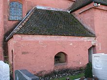
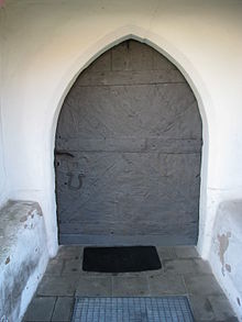
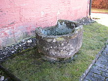
The church, an "important example of rural art", took several centuries to build. Probably the oldest is the tower basement with the very well preserved wall paintings that were uncovered in today's sacristy in 1936; the contour painting from 1380/90 shows motifs from the life of Jesus, the annunciation scene and the coronation of Mary as well as the four evangelist symbols. In 1487 the tower was brought into its current four-story shape. The original nave was connected to the west of the tower; the basement of the tower was the choir of this church. With a wall thickness of 1.10 to 1.20 meters, the tower has a fortress-like character; the church was probably a fortified church in the Middle Ages. The sign in front of the portal on the north side of today's nave, built in 1444, dates from the Baroque period. In 1445 the choir was built with a vault that is no longer preserved, as a combat stone behind the altar shows; In the 18th century a new vault was built, probably in order to be able to set up a larger altar. The year 1594 on the tower probably indicates an unknown redesign of the interior of the church. On the north side of the tower there is a cemetery chapel, which is no longer useful today. To the west of the portal is a former baptismal font made of sandstone from the castle. The four-column high altar is a late Rococo work by the Bittner brothers, two joiners from the neighboring village of Lohen. Above the tabernacle there is a figure of the patron saint, flanked by figures of St. Aloysius and St. Stanislaus Koska in the style of Jesuit art. Remains of an ornate sacrament house made of sandstone to the left of the choir date from the 16th century. The pulpit and the side altars are baroque; on the left there is a figure of the plague saint Rochus, flanked by figures of St. Lorenz and St. Barbara (both around 1510), on the right you can see a wooden relief of the Adoration of the Magi, "the oldest and most beautiful piece of the existing plastic representations". The pews have chair cheeks with scale patterns. The wooden ceiling of the nave shows a late Gothic stencil painting. The modern folk altar and the ambo were created in 2008 by the sculptor Rupert Fieger in Eichstätt from Solnhofen Jura limestone. The organ brochure dates from 1850, the organ itself from Dillingen organ builder Sandtner.
The church is considered a monument. It also regularly serves as a concert room. → List of architectural monuments in Mindorf .
The Kreuzstein near Mindorf on the outskirts reminds us that a merchant's son from Lübeck who is buried in the Johannesfriedhof in Nuremberg was murdered in 1646.
Personalities
- Helmut Gerlach, painter, graphic artist and sculptor, * 1921 in East Prussia; † 2009 in Mindorf
traffic
Mindorf is about 1.5 km west of the A 9 motorway . The district road RH 5 leads over the state roads St 2391 and St 2238 to the Hilpoltstein driveway (AS 56). There is a cultural hiking trail “To concrete remains of the Mindorf Line, a route project for the Rhine-Main-Danube Canal” (from 1939).
literature
- Franz Xaver Buchner: The diocese of Eichstätt. Volume I: Eichstätt 1937, Volume II: Eichstätt 1938
- Wolfgang Wiessner: Hilpoltstein . In: Commission for Bavarian State History at the Bavarian Academy of Sciences (Hrsg.): Historical Atlas of Bavaria . Part Franconia, Series I, Issue 24. Munich 1978, ISBN 3-7696-9908-4 ( digitized version ).
- Felix Mader (arr.): The art monuments of Bavaria. Middle Franconia administrative region. III. District office Hilpoltstein , Munich 1929, reprint Munich / Vienna 1983, pp. 233–240
Web links
- Mindorf on the Hilpoltstein website
- Filialkirche St. Stephan on the Hilpoltstein website
- Bell from St. Stephan
Individual evidence
- ^ Franz Tichy : Geographical Land Survey: The natural spatial units on sheet 163 Nuremberg. Federal Institute for Regional Studies, Bad Godesberg 1973. → Online map (PDF; 4 MB)
- ↑ a b Wolfgang Wiessner: Hilpoltstein . In: Commission for Bavarian State History at the Bavarian Academy of Sciences (Hrsg.): Historical Atlas of Bavaria . Part Franconia, Series I, Issue 24. Munich 1978, ISBN 3-7696-9908-4 , p. 35 ( digitized version ).
- ↑ a b c K. Bayer. Statistical Bureau (Ed.): Directory of localities of the Kingdom of Bavaria, with alphabetical register of places . LXV. Issue of the contributions to the statistics of the Kingdom of Bavaria. Munich 1904, Section II, Sp. 1220 ( digitized version ).
- ^ Wolfgang Wiessner: Hilpoltstein . In: Commission for Bavarian State History at the Bavarian Academy of Sciences (Hrsg.): Historical Atlas of Bavaria . Part Franconia, Series I, Issue 24. Munich 1978, ISBN 3-7696-9908-4 , p. 175 ( digitized version ).
- ^ Wolfgang Wiessner: Hilpoltstein . In: Commission for Bavarian State History at the Bavarian Academy of Sciences (Hrsg.): Historical Atlas of Bavaria . Part Franconia, Series I, Issue 24. Munich 1978, ISBN 3-7696-9908-4 , p. 46 ( digitized - note 139).
- ^ Wolfgang Wiessner: Hilpoltstein . In: Commission for Bavarian State History at the Bavarian Academy of Sciences (Hrsg.): Historical Atlas of Bavaria . Part Franconia, Series I, Issue 24. Munich 1978, ISBN 3-7696-9908-4 , p. 107 ( digitized version ).
- ^ Wolfgang Wiessner: Hilpoltstein . In: Commission for Bavarian State History at the Bavarian Academy of Sciences (Hrsg.): Historical Atlas of Bavaria . Part Franconia, Series I, Issue 24. Munich 1978, ISBN 3-7696-9908-4 , p. 157 ( digitized version ).
- ↑ Buchner I, p. 537; II, p. 834
- ↑ Carl Siegert: History of the rule, castle and town Hilpoltstein, their rulers and residents. In: Negotiations of the historical association of Upper Palatinate and Regensburg 20 (1861), p. 225
- ^ Wolfgang Wiessner: Hilpoltstein . In: Commission for Bavarian State History at the Bavarian Academy of Sciences (Hrsg.): Historical Atlas of Bavaria . Part Franconia, Series I, Issue 24. Munich 1978, ISBN 3-7696-9908-4 , p. 226 ( digitized version ).
- ↑ a b Wolfgang Wiessner: Hilpoltstein . In: Commission for Bavarian State History at the Bavarian Academy of Sciences (Hrsg.): Historical Atlas of Bavaria . Part Franconia, Series I, Issue 24. Munich 1978, ISBN 3-7696-9908-4 , p. 255 ( digitized version ).
- ↑ a b Joseph Heyberger, Chr. Schmitt, v. Wachter: Topographical-statistical manual of the Kingdom of Bavaria with an alphabetical local dictionary . In: K. Bayer. Statistical Bureau (Ed.): Bavaria. Regional and folklore of the Kingdom of Bavaria . tape 5 . Literary and artistic establishment of the JG Cotta'schen Buchhandlung, Munich 1867, Sp. 714 , urn : nbn: de: bvb: 12-bsb10374496-4 ( digital copy ).
- ↑ a b Kgl. Statistical Bureau (ed.): Complete list of localities of the Kingdom of Bavaria. According to districts, administrative districts, court districts and municipalities, including parish, school and post office affiliation ... with an alphabetical general register containing the population according to the results of the census of December 1, 1875 . Adolf Ackermann, Munich 1877, 2nd section (population figures from 1871, cattle figures from 1873), Sp. 890 , urn : nbn: de: bvb: 12-bsb00052489-4 ( digitized version ).
- ^ Wilhelm Volkert (ed.): Handbook of Bavarian offices, communities and courts 1799–1980 . CH Beck, Munich 1983, ISBN 3-406-09669-7 , p. 483 .
- ↑ Hilpoltsteiner Kurier of July 11, 2014
- ↑ Alphabetical index of all the localities contained in the Rezatkkreis according to its constitution by the newest organization: with indication of a. the tax districts, b. Judicial Districts, c. Rent offices in which they are located, then several other statistical notes . Ansbach 1818, p. 59 ( digitized version ).
- ↑ Th. D. Popp: Register of the Bissthumes Eichstätt . Eichstätt: Ph. Brönner 1836, p. 91
- ↑ Buchner I, p. 538
- ↑ Bavarian State Statistical Office (ed.): Official city directory for Bavaria, territorial status on October 1, 1964 with statistical information from the 1961 census . Issue 260 of the articles on Bavaria's statistics. Munich 1964, DNB 453660959 , Section II, Sp. 797 ( digitized version ).
- ^ Bavarian State Statistical Office (ed.): Official place directory for Bavaria . Issue 335 of the articles on Bavaria's statistics. Munich 1973, DNB 740801384 , p. 166 ( digitized version ).
- ↑ Bavarian State Office for Statistics and Data Processing (Ed.): Official local directory for Bavaria, territorial status: May 25, 1987 . Issue 450 of the articles on Bavaria's statistics. Munich November 1991, DNB 94240937X , p. 348 ( digitized version ).
- ↑ site hilpoltstein.de
- ^ Georg Dehio: Handbook of German Art Monuments. Bavaria I: Franconia. 2nd, revised and supplemented edition, Munich: Deutscher Kunstverlag 1999, p. 627
- ↑ The fortified church protects its secrets . In: Hilpoltsteiner Kurier from February 2, 2013; Hans Georg Heydler: The Church of Mindorf, a testimony to rural craftsmanship . In: Heimatkundliche Streifzüge, series of publications des Landkreis Roth, issue 17 (1998), pp. 54–59; Out and about together. Churches and parishes in the district of Roth and in the city of Schwabach , Schwabach / Roth undated [2000], p. 112 f.
- ↑ site bistum-eichstaett.de
- ↑ Field crosses in view . In: Hilpoltsteiner Kurier of April 26, 2011 and November 28, 2013
- ↑ Gerlach works in the barn. In: Hilpoltsteiner Kurier from June 3, 2015
- ↑ [1]


