Bern-Eichholz
|
Eichholz Common quarter of Bern |
|
|---|---|
| Coordinates | 595 836 / 200387 |
| height | 483- 566 m |
| surface | 0.71041 km² |
| Residents | 0 (2019) |
| Population density | 0 inhabitants / km² |
| Quarter number | 602 |
| Post Code | 3027, 3032 |
| Statistical district | Bethlehem |
| district | Bümpliz-Oberbottigen |
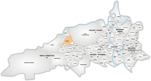
The Eichholz is a forest and a common quarter in the VI Bümpliz-Oberbottigen district and the statistical district 32 Bethlehem in the city of Bern . It borders on Eymatt , Gäbelbach , Holenacker , Ackerli and Bethlehemacker . In the east lies the Great Bremgarten Forest .
No residents are registered in Eichholz, the area is predominantly forested.
The name Eichholz as a forest in the Bümpliz parish can be traced back historically. The neighboring Bremgartenwald of the same kind belonged to the parish of Bern, which influences the distinction to this day. An Eichholz park of the same name is located on the banks of the Aare Wabern near Bern , where a lido and a campsite also bear this name. This forest belonged to the parish of Köniz.
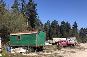
At least temporarily, the city nomads have camps with their caravans in a clearing . The Autobahn 1 cuts through the oak wood.
Web links
- Common Eichholz quarter on map.bern.ch
Individual evidence
- ↑ Interactive city map of the city of Bern (selection under "Topics")
- ↑ Resident population 2019 (PDF, 4.3 MB) City of Bern, March 2020, p. 14 , accessed on March 30, 2020 .
- ^ The localities of the Federal Free State of Bern. Hallersche Buchdruckerei, 1838, pp. 432, 444 , accessed on April 7, 2020 .
- ↑ City nomad camp: Google Earth 46 ° 57'27.08 "N 7 ° 23'13.67" E


