Capileira
| Capileira municipality | ||
|---|---|---|
| coat of arms | Map of Spain | |

|
|
|
| Basic data | ||
| Autonomous Community : | Andalusia | |
| Province : | Granada | |
| Coordinates | 36 ° 58 ′ N , 3 ° 22 ′ W | |
| Height : | 1436 msnm | |
| Area : | 57 km² | |
| Residents : | 554 (Jan. 1, 2019) | |
| Population density : | 9.72 inhabitants / km² | |
| Postal code : | 18413 | |
| Municipality number ( INE ): | 18042 | |
| administration | ||
| Website : | www.capileira.es | |
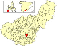
| Location of the municipality | ||

|
||
Capileira is a municipality in the Alpujarra Mountains in the Spanish province of Granada .
Capileira is 1436 meters above sea level, making it the second highest village in Spain after Trevélez . The place has the typical village structure for this area consisting of upper, middle and lower village. The houses, some of which are hundreds of years old, are mostly white and simple, arranged in cubes above and next to each other. In addition to tourism, the most important branch of the economy is the production of special, long-haired blankets. In the same valley a little to the south are the villages of Bubión and Pampaneira .
Gerald Brenan described the Capileira 1920s in his 1957 autobiography "South of Granada".
Web links
Commons : Capileira - collection of images, videos and audio files
Individual evidence
- ↑ Cifras oficiales de población resultantes de la revisión del Padrón municipal a 1 de enero . Population statistics from the Instituto Nacional de Estadística (population update).

