Atarfe
| Atarfe parish | ||
|---|---|---|
| coat of arms | Map of Spain | |

|
|
|
| Basic data | ||
| Autonomous Community : |
|
|
| Province : | Granada | |
| Comarca : | Vega de Granada | |
| Coordinates | 37 ° 13 ′ N , 3 ° 41 ′ W | |
| Area : | 47.25 km² | |
| Residents : | 18,706 (Jan. 1, 2019) | |
| Population density : | 395.89 inhabitants / km² | |
| Postal code : | 18230 (Atarfe y Hurpe) 18290 (Caparacena) 18330 (Sierra Elvira) |
|
| Municipality number ( INE ): | 18022 | |
| administration | ||
| Mayor : | Tomás Ruiz Maeso PSOE | |
| Address of the municipal administration: | Plaza de España Nº 7 - 18230 Atarfe (Granada) - Tel .: +34 958436011 | |
| Website : | ciudadatarfe.com | |
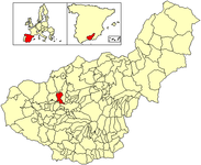
| Location of the municipality | ||

|
||
Atarfe is a place near Granada in the southern Spanish province of Granada in the autonomous region ( Andalusia ).
etymology
The etymology of the place name has not been conclusively clarified, but all of the toponomasts involved agree that the place name comes from the Moorish era.
politics
| Political party | 2011 | 2015 | ||
|---|---|---|---|---|
| Be right % | Seats | Be right % | Seats | |
| PP | 33.16% | 6th | - | - |
| PSOE | 42.41% | 7th | - | - |
| IULV-CA | 21.44% | 4th | - | - |
Source: Spanish Ministry of the Interior
geography
With almost 16,000 inhabitants, Atarfe is the twelfth largest municipality in the province of Granada. Atarfe belongs to the Comarca Vega de Granada and is located at the foot of the Sierra Elvira, one of the foothills of the Sierras Subbéticas (Cerro de los Cigarrones). The Genil flows south of the city . The nearest neighboring cities are (in alphabetical order) Albolote , Colomera , Granada , Maracena , Moclín , Pinos Puente and Santa Fe .
Transport links
Atarfe is touched by the Autovía A-92, on which - in the urban area of Santa Fe - the Granada-Jaén Airport is located and which intersects with the Autovía A-44 in the neighboring town of Albolote . The Málaga -Granada and Algeciras -Granada railway lines run through the city.
economy
Atarfe's agricultural products consist partly of olives and olive products from the higher regions, while tobacco is still grown in Vega .
In Sierra Elvira, marble is extracted in quarries .
Population development

history
In the districts of Sierra Elvira and Baños de Sierra Elvira are the ruins of an initially Roman and later Moorish city, which are currently being investigated by the team led by Professor of Material Culture and Medieval Archeology Antonio Malpica Cuello. In agreement with the statements of the last Zīrīdenkönig of Granada 'Abdallāh ibn Buluggīn and the place name Elvira, the medieval archaeologists suspect the ancient Roman- Iberian Illiberis (or the Municipium Florentinum Iliberitanum) or the Moorish Ilbīra, whereas the ancient historians in Granadas Illiberis / Granada to suspect more precisely on the Albaicín .
Web links
Individual evidence
- ↑ Cifras oficiales de población resultantes de la revisión del Padrón municipal a 1 de enero . Population statistics from the Instituto Nacional de Estadística (population update).
- ^ Elecciones Locales 2011 - Resultados provisionales ( Spanish ) Ministerio del Interior. May 22, 2011. Accessed January 21, 2019.

