
Buchfart
| coat of arms | Germany map | |
|---|---|---|

|
Coordinates: 50 ° 55 ' N , 11 ° 20' E |
|
| Basic data | ||
| State : | Thuringia | |
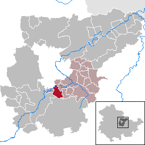
| County : | Weimar Country | |
| Management Community : | Mellingen | |
| Height : | 258 m above sea level NHN | |
| Area : | 7.21 km 2 | |
| Residents: | 195 (Dec. 31, 2019) | |
| Population density : | 27 inhabitants per km 2 | |
| Postal code : | 99438 | |
| Area code : | 03643 | |
| License plate : | AP, APD | |
| Community key : | 16 0 71 009 | |
| LOCODE : | DE UFH | |
| Address of the municipal administration: |
Weimar Str. 7 99438 Buchfart |
|
| Mayor : | Oliver Karls | |
| Location of the municipality of Buchfart in the Weimarer Land district | ||
  |
||

Buchfart is a municipality in the south of the Weimarer Land district and part of the Mellingen administrative community .
geography

Buchfart is located about 17 kilometers southwest of the district town of Apolda and about 7 kilometers south of the city of Weimar in the Ilm valley . The highest elevation is the Balsamine ( 340.6 m above sea level ), a foothill of the Rosenberg ( 379.9 m above sea level ), which, however, already belongs to the corridor of the Weimar district of Legefeld .
history
On the northern bank of the Ilm, the area on the Prallhang had attracted settlement as early as the Neolithic and later, as has been proven by archaeological finds.
The place name Buchfart refers to an important ford in the beech forest. The place was first mentioned in 1348 with Lutolf von Heitingsburg residence in Buchverte . At that time the Counts of Orlamünde had suzerainty in Buchfart, which came to the Counts of Schwarzburg in 1395. Apparently the rock castle and the Buchfarter Ilmfurt served an old road that climbed the steep slope of the Ilm valley right next to the castle; the supporting walls and the remains of sunken paths are said to have been visible in the undergrowth in the 19th century. The forests around Buchfart and Hetschburg , rich in game, were popular hunting grounds for the Weimar court.
Buchfart Castle also attracted researchers. As early as 1551, the mineralogist and mining expert Georgius Agricola had ascended to the chambers of the rock castle, as he was vividly assured that troglodytes - dwarf-like "subterranean creatures" once lived there. In 1822, the local history researcher Karl Gräbner examined the legendary castle complex for days and published the book "The old Bergschloß Buchfart in the Grand Duchy of Weimar".
Attractions
Rock castle
The rock cliffs opposite the location of Buchfart are in constant change due to progressive erosion , the rock castle located there is also referred to as a cave castle in the literature , the expansion of the complex probably began as early as the 10th century. It is considered a specialty in the Thuringian castle landscape. The system consisted of about twelve chambers and corridors that extended up to 40 meters above the valley floor. The former access situation and the outer walls can no longer be reconstructed. In its heyday, the castle offered the best possible protection from attackers, but on the other hand the living conditions inside the castle were certainly extreme. The facility was abandoned as early as 1440. In the meantime, nature has destroyed a significant part of the castle. In 2009, extensive securing work on the rock face was necessary; it is now hoped to have saved a large part of the remaining ruins.
Ilm bridge and mill

The covered wooden bridge over the Ilm, built between 1816 and 1818, is another sight of the town. (Until 1613 the bridge was made of stone.) The listed bridge is 43 meters long, three meters wide and has a clearance height of 3 meters. 05 meters. The bridge is still passable. The design comes from the Weimar building officer Carl Friedrich Christian Steiner . Next to the bridge is a listed watermill. The ensemble is one of the most popular photo motifs.
Village church
The Buchfarter church " To our dear women " is essentially a Gothic building from the 14th century. The nave, however, dates from the 18th century. The church was completely renovated in 1870.
Area hiking trails
The Goethe hiking trail Weimar – Großkochberg and the “Drei-Türme-Wanderweg” run through Buchfart , which leads from the village directly to the neighboring Paulinenturm near Bad Berka .
Balms
The scenic charm of the Ilm Valley near Buchfart led to its designation as a " Middle Ilm Valley Landscape Protection Area ". Lively tourism began here as early as the 18th century. Above the rock castle, the inn "Güntsches Ruh" was built in 1894 by Balduin Zorn. In 1924 it was destroyed by fire. The current excursion restaurant " Balsamine " was built in 1931. It received its poetic name after the locust trees planted here , which enchant the place with their sweet, beguiling scent in spring.
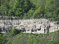
Rock castle photographed from the opposite side of the valley

Wooden bridge over the Ilm

Inside view of the bridge

Watermill
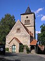
Village church
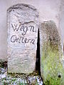
Signpost stone


Personalities
- Volckmar Leisring (around 1588–1637), pastor in Buchfart until his death in 1629
Web links
Individual evidence
- ^ Population of the municipalities from the Thuringian State Office for Statistics ( help on this ).
- ↑ Michael Köhler: Thuringian castles and fortified prehistoric and early historical living spaces . Jenzig-Verlag Köhler, Jena 2001, ISBN 3-910141-43-9 , Buchfart, p. 73 .
- ↑ a b Thuringian Open Air Museum Hohenfelden (ed.): On the way in the Ilm valley. Interesting facts and information for tourists and locals . MFB-Verlagsgesellschaft, Eisenach 1998, ISBN 3-931431-10-X , Buchfart, p. 43-44, 48-49 .
- ↑ a b Ernst Leissling: The middle Ilmtal . Greifenverlag, Rudolstadt 1966, p. 186-187 .
- ↑ Heiko Laß: Hunting and pleasure castles. Art and culture of two sovereign building tasks. Shown on Thuringian buildings of the 17th and 18th centuries = hunting and pleasure palaces of the 17th and 18th centuries in Thuringia . Michael Imhof, Petersberg 2006, ISBN 3-86568-092-5 , p. 410–411 (At the same time: Aachen, Technical University, dissertation, 2004).
- ↑ http://www.brueckenweb.de/2content/datenbank/bruecken/3brueckenblatt.php?bas=1568
- ↑ Bad Berka Tourist Information Office: leaflet on the “Drei-Türme-Weg”.
Remarks
- ↑ From the restaurant you can also see the "Bärfangsgrund". It can no longer be proven whether bears actually lived there.
At Ettersberg | Apolda | Bad Berka | Bad Sulza | Ballstedt | Blankenhain | Buchfart | Dobrich | Eberstedt | Ettersburg | Frankendorf | Grammetal | Big herring | Großschwabhausen | Hammerstedt | Hetschburg | Hohenfelden | Ilmtal Wine Route | Kapellendorf | Kiliansroda | Kleinschwabhausen | Klettbach | Crane field | Lehnstedt | Magdala | Mechelroda | Mellingen | Nauendorf | Neumark | Niedertrebra | Obertrebra | Oetter | Rannstedt | Rittersdorf | Blacksmiths | Tonndorf | Umpferstedt | Vollersroda | Wiegendorf