
Göstinger ruins mountain
| Göstinger ruins mountain | ||
|---|---|---|
 View from the Admonter Kogel (northeast) |
||
| height | 574 m above sea level A. | |
| location | Styria , Austria | |
| Mountains | Grazer Bergland , Lavanttal Alps | |
| Coordinates | 47 ° 6 '14 " N , 15 ° 22' 51" E | |
|
||
| rock | Limestone , dolomite | |
| Age of the rock | 400-350 million years | |
| particularities | Gösting ruins , Plabutschtunnel (A 9) | |

The Göstinger ruins mountain , historically Annaberg , is 574 m above sea level. A. high foothills of the Flösserkogel ( 696 m above sea level ) north of Graz . The ruins of Gösting stand on it .
Location and landscape
The mountain forms an east-grazing ridge around which the Mur forms its knee when it leaves the Alps and enters the Graz basin , with which the ruin mountain forms its north-western end. At its southeastern foot is the place Gösting , today the 13th district of the state capital of Styria, in the north Raach , also a district. The mountain is separated from the city mountain Plabutsch in the south by the valley of Thal with the Thaler Bach .
The mountain has always played an important strategic role historically, which is why an important fortress was built on it with the Gösting hill fort in the 11th century. The Cholera Chapel of the Holy Trinity , built in 1833, is located on the mountain to the east of the ruins, and to the west is St. Annenbründl .
The traffic situation as a bottleneck still has an impact today, on the steep north flank of the ruin mountain, called Jungfernsprung , is the north portal of the Plabutsch tunnel , on which the Pyhrn Autobahn (A 9) bypasses the city of Graz to the west.
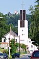
Ruins mountain with ruins Gösting , behind the church St. Anna Gösting
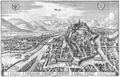
Gratz , in Zeiller, Merian Topographia Provinciarum Austriacarum 1679 (see view in the info box)

Cholera chapel
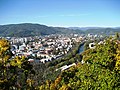
View from the Schloßberg in north direction: on the left Plabutsch with Hubertushöhe, center of the picture ruins mountain with ruins of Gösting, then Admonter Kogel on the left of the Mur; behind the gleine pe
.JPG)
.jpg)


Development
A hiking trail leads over the mountain from Gösting over the ruins path to the ruins, and from there down again over the Jungfernsprung to Raach an der Mur, or to the Annenbründel, and from there to Thal-Oberbichl , or over the Steinkogel down to Straßengel in the Gratkorner basin .
Individual evidence
- ↑ The mountain is not listed by name in ÖK 50 or in GEONAM Austria , but can be found in local literature. The historical name, after the parish of Gösting and the Bründl, can still be found in the Josephinische Landesaufnahme 1787, online see GIS-Steiermark ( page no longer available , search in web archives ) Info: The link was automatically marked as defective. Please check the link according to the instructions and then remove this notice.
-
↑ a b Cholera chapel on the occasion of being spared the epidemics of 1830 and 1832
maiden jump after Anna von Gösting, who is said to have thrown herself down here because of lovesickness,
both information in: Reinhard M .: Sights in Stattegg, St.Veit, Graz-Andritz and the surrounding area ( Memento of the original from November 11, 2013 in the Internet Archive ) Info: The archive link was inserted automatically and has not yet been checked. Please check the original and archive link according to the instructions and then remove this notice. - ↑ Hiking trails , municipality of Thal> Leisure and Tourism

Inner City: Cathedral | Antoniuskirche | Trinity Church | Franciscan Church | Katharinenkirche | City Parish Church | Staircase church
Left bank of the Mur: Barack Church Graz-Liebenau | Brother Klaus Church | St. Christoph | Church of Christ the Risen | Church of the Redeemer in the State Hospital | Ev. Church of the Redeemer (Liebenau) | Grabenkirche | Ev. Heilandskirche | Church Holy Family | Sacred Heart Church | Ev. St. John's Church | Joseph Church | Carmelite Church Maria Schnee | Carmelite Church of St. Joseph | Kreuzschwesternkirche | Leechkirche | Leonhard Church | Mariatrost Basilica | Church of Mary Green | Church of the Annunciation | Mater Dolorosa | Münzgrabenkirche | St. Paul (Liebenau) | St. Paul (Waltendorf) | St. Peter | Parish Church of St. Veit Salvatorkirche | Ulrichsbrunn
Right bank of the Mur: All Saints Church | Retirement home church | Old Catholic Church | Andräkirche | Anna Church Graz-Gösting | Institution Church of the Holy Cross in the LKH Graz II location south | Church of Mercy | Church of the Sisters of Mercy | Bürgerspitalkirche | Cholera Chapel | Christ the King's Church (Raach) | Parish Church of Christ the King (Wetzelsdorf) | Ev. Christ Church | Don Bosco Church | Elizabethine Church | Elisabeth Church | Florian Church | Church of the Crucified Savior | Castle Chapel Gösting | Good Shepherdess Monastery Church | St. John's Church | Church of Johann and Paul | Kalvarienbergkirche | Karlauerkirche | Ev. Kreuzkirche | St. Leopold | St. Luke | Mariahilferkirche | Maria in misery at Straßgang | Castle Church of St. Martin | Ruperti Church | Lazarist Church | School Sisters Church | Guardian Angel Church | Synagogue | Church of the Fourteen Holy Helpers | Vincent Church | Welsche Church