Gaya (district)
| Gaya District गया ज़िला |
|
|---|---|

|
|
| State | Bihar |
| Division : | Magadh |
| Administrative headquarters : | Gaya |
| Area : | 4976 km² |
| Residents : | 4,391,418 (as of 2011) |
| Population density : | 883 inhabitants / km² |
| Website : | Gaya district |
The district of Gaya ( Hindi : गया ज़िला) is a district of the Indian state of Bihar . The administrative and economic center is the city of Gaya , which has almost 500,000 inhabitants .
geography
The Gaya district is located in the south of the state of Bihar; it forms the transition from the approx. 300 m high northern foothills of the Vindhya Mountains to the Ganges plain, which is only 100 m high . It is bordered to the west by the Aurangabad district , to the northwest by the Arwal district , to the north by the Jehanabad district , to the northeast by the Nalanda district , to the east by the Nawada district and to the south by the state of Jharkhand . The most important river is the Falgu and its two source rivers Lilajan and Mohana . The most important cities are Gaya with almost 500,000 as well as Bodhgaya and Sherghati with over 40,000 inhabitants each. The climate is warm to hot; Rain falls almost exclusively in the summer monsoon months .
population
Official population statistics have only been kept and published since 1991.
| year | 1991 | 2001 | 2011 |
| Residents | 2,664,803 | 3,473,428 | 4,391,418 |
Hindus dominate the rural villages (approx. 88.5%); there is also a not inconsiderable number of Muslims in the cities (approx. 11% of the total population); Sikhs , Buddhists , Jains and Christians are numerically only small marginal groups. In the decade between 2001 and 2011, the population grew by a good 20% to just under 4.5 million, with the male population exceeding the female population by around 5%. Almost 87% of the population lives in rural villages; a third of the people (mostly women) are considered illiterate. Mostly Hindi is spoken .
economy
Agriculture has traditionally played the dominant role in the district's economic life; The main crops are rice , lentils , wheat and rapeseed . Crafts, trade and smaller industrial and service companies have settled in the cities. Textile production plays an important role.
history

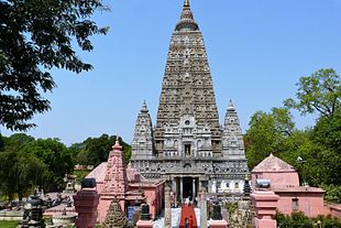
The city of Gaya is already mentioned in the ancient Indian epic Ramayana ; in the Mahabharata it appears under the name Gayapuri . According to tradition, Siddharta Gautama ( Buddha ) obtained his enlightenment under a Bodhi tree in Bodhgaya. The remote region has been in the hands of tribes for centuries. It was not until the 16th century that Sasaram- born Sher Khan Suri (ruled approx. 1530–1545) and his son Islam Shah Suri (r. 1545–1553) managed to temporarily organize the area, modernize it and use the old Grand Trunk Road to connect to Central India and Bengal . After their death, however, it was only a marginal zone of the Mughal Empire and then of British India . The district was established in 1865; in 1976 and 1988 the newly created districts of Aurangabad, Nawada and Jehanabad were split off. The entire district belongs to the Naxalite - communist influenced " Red Corridor ".
Attractions
The main attractions of the district are all in the old town of Bodhgaya, about 15 km south of Gaya.
Web links
- Gaya District - Information (English)
