
Groundless moor
|
Grundlos Moor nature reserve
|
||
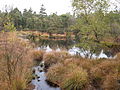
 Swinging lawn at the Grundlose See |
||
| location | Southwest of Ebbingen in Lower Saxony Heidekreis | |
| surface | 295.0 ha | |
| Identifier | NSG LÜ 185 | |
| WDPA ID | 163401 | |
| FFH area | 278.4 ha | |
| Geographical location | 52 ° 54 ' N , 9 ° 33' E | |
|
||
| Sea level | from 62 m to 74 m | |
| Setup date | 2nd September 1990 | |
| administration | NLWKN | |

The Grundlose Moor is the largest still almost intact high moor in the Heidekreis district , Lower Saxony . It is designated as a nature reserve.
description
The Grundlose Moor is five kilometers northwest of the city center of Walsrode and has an area of just under 3 square kilometers. Its center is about 2 kilometers southwest of the village of Ebbingen and about 3.5 kilometers north of the village of Fulde (both districts of the city of Walsrode).
In the past, the moor was used for cutting peat , especially in its southern part , but regenerates itself after individual watering measures. The shores of the Grundlose See lake , located in the middle of the moor, are usually formed as a clear edge due to the impact of waves, only in the south-west vibrating lawns protrude far into the lake. Cotton grass , cranberries , peat moss and bell heather are found in the bottomless moor , as well as bogberry in large stands .
The moor has developed in the northeast half of a 4 km long valley at a height of 60 to 70 meters , which is enclosed by two inconspicuous parallel terminal moraine walls. The 70 to 81 meter high marginal hills and the depression itself are covered by ground moraine from the Saale Ice Age . It is drained by a ditch that represents the upper reaches of the Fulde .
By ordinance of July 30, 1990, the Grundlose Moor was declared a nature reserve (with the registration number NSG LÜ 185). The protected area has an area of 295 hectares. The district of Heidekreis is responsible as the lower nature conservation authority.
Bottomless lake
The Grundlose Lake, which is a good 2 meters deep, is 440 meters long from north to south and up to 170 meters wide in the north. It has an area of 4.7 hectares and is 72.5 meters above mean sea level. About 400 meters to the northeast are the elliptical small lake with a diameter of 50 to 70 meters and two other slightly smaller water areas.
The Gratuitous lake was originally a nearly silted glacial lake left behind, its preservation is not only due to the abdämmende raised peat bog, but also processes a Hochmoorkolkbildung .
The lake can be hiked around from the hiking car parks in the east ( Ebbingen ) and south (north of Fulde ).
There is also a lake of the same name in Upper Bavaria, near the Chiemsee .
Picture gallery

Groundless moor, October 2010
Former peat cuttings, October 2010

Bottomless lake with moraine hill, October 2010

Bog vegetation at Grundlose See, October 2013


literature
- Ernst Andreas Friedrich : Lower Saxony. Nature's treasure trove. Landbuch-Verlag GmbH, Hanover 1987, ISBN 3-7842-0369-8
See also
Web links
- Photo gallery bottomless moor with lake
- Moor photo gallery
- Nature reserve "Grundlos Moor" in the database of the Lower Saxony State Office for Water Management, Coastal and Nature Conservation (NLWKN)
- Literature list (1978–1998) of the NLWKN on the nature reserve "Grundlos Moor"


Aller-Leinetal | Allern lowlands near Klein Häuslingen | All loops between Wohlendorf and Hülsen | Bansee | Birch Lake | Böhmetal near Huckenrieth | Brambosteler Moor | Ehbläcksmoor | Great moor near Becklingen | Groundless moor | Barrow heather near Langeloh | Lehrdetal | Lichtenmoor | Lönsgrab | Lührsbockeler Moor | Lüneburg Heath | Moor near Osterwede | Moor in the Schotenheide | Upper Wümmeniederung | Upper Fintautal | Ottinger Ochsenmoor | Riensheide with Stichter See and Sägenmoor | Black moor near Dannhorn | Seemoor and Schwarzes Moor near Zahrensen | Söhlbruch | Valley of the Little Örtze | Vehmsmoor | Wietzendorfer Moor | Wittenmoor