
Hacıqabul (Rayon)

Hacıqabul , also Hajigabul , is a rayon in eastern Azerbaijan . The capital of the district is the city of the same name Hacıqabul (formerly Qazı Məmməd or Qazıməmməd , Russian Кази-Магомед / Kasi-Magomed ).
geography
The rayon has an area of 1640 km². The landscape belongs to the steppe of Shirvan and is traversed by the Hacıqabul . The Kura River forms the southwestern border .
population
The rayon had 65,500 inhabitants in 2009. These are spread across the capital and 30 other places.
economy
Oil production plays an important role in the Rajon's economy , especially in the area of the Şahdağ and Mişovdağ mountain ranges running through the area from northwest to southeast. Otherwise the region is characterized by agriculture. It is mainly cattle breeding (cattle and sheep) and grain and vegetables are grown along the Kura and in the Pirsaat valley . There are three agribusinesses and 47 other farms.

Mud volcanoes with emerging oil can be found in many places
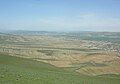
The valley of the Pirsaat river with the village of Birinci Udullu in the north of the raion. On the horizon the snow-capped peaks of the Greater Caucasus beyond Şamaxı

Economy of the Rajon: oil production (here at the Kəlaməddin deposit) and cattle farming


Architectural monuments
In the district are the remains of the Hanega fortress .
Individual evidence
- ↑ a b c Azerbaijan Development Gateway ( Memento of November 14, 2008 in the Internet Archive ) about the rayon
- ↑ Azerbaijani Statistical Authority ( Memento of November 14, 2010 in the Internet Archive )
Rayons : Abşeron | Ağcabədi | Agdam | Ağdaş | Ağstafa | Ağsu | Astara | Balakon | Bərdə | Beyləqan | Biləsuvar | Cəbrayıl | Cəlilabad | Daşkəsən | Füzuli | Gədəbəy | Goranboy | Göyçay | Göygöl | Hacıqabul | İmişli | İsmayıllı | Kəlbəcər | Kürdəmir | Laçın | Lənkəran | Lerik | Masallı | Neftçala | Oğuz | Qax | Qazax | Qəbələ | Qobustan | Quba | Qubadlı | Qusar | Saatlı | Sabirabad | Şabran | Salyan | Şamaxı | Samux | Şəki | Şəmkir | Siyəzən | Şuşa | Tərtər | Tovuz | Ucar | Xaçmaz | Xızı | Xocalı | Xocavənd | Yardımlı | Yevlax | Zaqatala | Zəngilan | Zərdab
Cities: Bakı | Gəncə | Lənkəran | Mingəçevir | Naftalan | Şəki | Şirvan | Sumqayıt | Şuşa | Xankəndi | Yevlax
Autonomous Republic : Nakhichevan (Naxçıvan)
Rays of the Autonomous Republic: Babək | Culfa | Kəngərli | Ordubad | Sədərək | Şahbuz | Şərur
City: Naxçıvan
Coordinates: 40 ° 6 ' N , 49 ° 0' E