
Jacob's Rest
|
Jacob's Rest
community Neuendettelsau
Coordinates: 49 ° 17 ′ 48 ″ N , 10 ° 49 ′ 57 ″ E
|
|
|---|---|
| Height : | 423 m above sea level NHN |
| Residents : | 17 (Dec. 31, 2013) |
| Incorporation : | January 1, 1972 |
| Postal code : | 91564 |
| Area code : | 09874 |
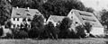
 Jakobsruh, west side
|
|

Jakobsruh (colloquially: Jakobsrū ) is a district of the community Neuendettelsau in the district of Ansbach in Middle Franconia .
geography
The wasteland lies in the valley of the Aurach , into which the Reutgraben flows on the right. Approx. The Aschberg ( 434 m above sea level ) is 0.5 km southeast of the village . A residential road leads to Haag (1.1 km west).
history
The country house was built in 1770/73 by the then Heilsbronn monastery administrator Jakob Weinhardt near the abandoned Girkenhof . The stones from Heilsbronn's Katharinenkirche , which was demolished in 1770, and those from the collapsed tower of St. Stephen's Church in Wollersdorf also served as building material . In the first written evidence from 1794, this country estate was named "Jacobs Ruh" after the first name of its owner. There was also the name after the field name "Altenwöhr".
At the end of the 18th century, Jakobsruh belonged to the real municipality of Haag. The property was owned by the Brandenburg-Ansbach monastery administrator in Heilsbronn as the landlord. Under the Prussian administration (1792–1806) of the Principality of Ansbach, the Jakobsruh received the number 18 of the place Haag when the house numbers were assigned. From 1797 to 1808 the place was under the Justice and Chamber Office Windsbach .
As part of the community edict, Jakobsruh was assigned to the Aich tax district formed in 1808 . It also belonged to the rural community of Aich, founded in 1810 . With the second parish edict (1818), Jakobsruh was transformed into the newly formed rural parish of Haag .
In 1836 Jakobsruh became the property of the Chief Postmaster von Axthelm, from 1868 it belonged to the farmer Georg Geiselbrecht. In 1897 it was acquired by the Neuendettelsau Deaconess Institute and expanded in 1902 with an inn and a nursing home. In 1967 the old Jakobsruh and the inn had to be demolished due to disrepair. Only the foundation is still preserved. The inventory of the old Jakobsruh was partially salvaged and restored. These include paintings by Johann Jakob Kleemann (1739–1790), which are exhibited today in the Ansbach City and District Museum.
On January 1, 1972, Jakobsruh was incorporated into Neuendettelsau as part of the regional reform .
The property is now privately owned.
Architectural and ground monuments
- House No. 18: a two-storey guest house with a hipped roof, built as a country house in 1740, with later alterations; was demolished in 1967.
- To the north on the slope was a Neolithic settlement .
Population development
| year | 1818 | 1840 | 1861 | 1871 | 1885 | 1900 | 1925 | 1950 | 1961 | 1970 | 1987 | 2007 | 2013 |
|---|---|---|---|---|---|---|---|---|---|---|---|---|---|
| Residents | 7th | 5 | 15th | 10 | 8th | 12 | 39 | 26th | 10 | 6th | 9 | 6th | 17th |
| Houses | 1 | 1 | 1 | 1 | 2 | 1 | 1 | 1 | 1 | 1 | |||
| source |
Historical pictures

Site map 1821
Jacob's Rest (1896)
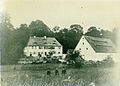
In the 19th century

.jpg&filetimestamp=20090114190615&)
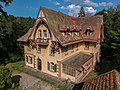
Current pictures
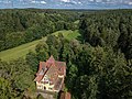
Jakobsruh, August 2017


.jpg)
.jpg)
.jpg)
.jpg)
religion
The inhabitants of the Evangelical Lutheran denomination were originally parish to St. Michael (Weißenbronn) , since 1897 to St. Nikolai (Neuendettelsau) . The inhabitants of the Roman Catholic denomination are parish according to St. Franziskus (Neuendettelsau) .
literature
- Johann Kaspar Bundschuh : Jakobsruhe . In: Geographical Statistical-Topographical Lexicon of Franconia . tape 6 : V-Z . Verlag der Stettinische Buchhandlung, Ulm 1804, DNB 790364328 , OCLC 833753116 , Sp. 799 ( digitized version ).
- Elisabeth Fechter: The place names of the district of Ansbach . Inaugural dissertation. Erlangen 1955, DNB 480570132 , p. 102-103 .
- Günther P. Fehring : City and district of Ansbach (= Bavarian art monuments . Volume 2 ). Deutscher Kunstverlag, Munich 1958, DNB 451224701 , p. 114 .
- Manfred Jehle: Ansbach: the margravial chief offices Ansbach, Colmberg-Leutershausen, Windsbach, the Nuremberg nursing office Lichtenau and the Deutschordensamt (Wolframs-) Eschenbach (= historical atlas of Bavaria, part Franconia . I, 35). tape 2 . Commission for Bavarian State History, Munich 2009, ISBN 978-3-7696-6856-8 , p. 863 .
- Manfred Keßler: The knight's seat in Dettelsau in the high and late Middle Ages . (Dissertation). Erlangen 2009, DNB 998940933 , p. 441-442 ( PDF; 11.1 MB ).
- Hans Rößler (Ed.): Under thatched and tile roofs. From the Neuendettelsau story . Freimund-Verlag, Neuendettelsau 1982, ISBN 3-7726-0110-3 , p. 109-112 .
Web links
- Jakobsruh on the website bavarikon
- Jakobsruh in the location database of the Bayerische Landesbibliothek Online . Bavarian State Library
- Jakobsruh in the Topographia Franconiae of the University of Würzburg , accessed on September 14, 2019.
- Jakobsruh in the historical directory of the association for computer genealogy
Remarks
- The distance information corresponds to the beeline between the respective geographic objects. They do not give the route .
- A detailed list of the responsible judicial and administrative authorities can be found in the article of the (former) municipality responsible for the district.
- The guidelines of the statistical surveys were changed several times during the period shown, which is why the information on population development - number of inhabitants and number of houses - does not count the same depending on the point in time. For more information, see the official regional directories for Bavaria .
Individual evidence
- ↑ a b Neuendettelsau municipal administration (ed.): Neuendettelsau. Information, authorities guide . Neuendettelsau 2014, p. 7.
- ↑ a b E. Fechter, p. 102f.
- ↑ Jakobsruh in the Bavaria Atlas
- ↑ This type of naming continued in the 17th and 18th centuries. Century and was initially applied to princely residences or country manors. The most prominent example is Karlsruhe .
- ↑ M. Jehle, Vol. 2, p. 863.
- ↑ JK Bundschuh, Vol. 6, Col. 799.
- ↑ State Archives Nuremberg , Government of Middle Franconia, Chamber of the Interior, Levy 1952, 3850: Formation of the municipal and rural communities in the district court Heilsbronn 1810. Quoted from M. Jehle, vol. 2, p. 963.
- ↑ H. Rößler, p. 109 ff.
- ^ GP Fehring, p. 114.
- ↑ Only inhabited houses are given. In 1818 these were known as fireplaces , in 1840 as houses and from 1885 to 2013 as residential buildings.
- ↑ Alphabetical index of all the localities contained in the Rezatkkreis according to its constitution by the newest organization: with indication of a. the tax districts, b. Judicial Districts, c. Rent offices in which they are located, then several other statistical notes . Ansbach 1818, p. 44 ( digitized version ).
- ↑ Eduard Vetter (Ed.): Statistical handbook and address book of Middle Franconia in the Kingdom of Bavaria . Self-published, Ansbach 1846, p. 147 ( digitized version ).
- ^ Joseph Heyberger, Chr. Schmitt, v. Wachter: Topographical-statistical manual of the Kingdom of Bavaria with an alphabetical local dictionary . In: K. Bayer. Statistical Bureau (Ed.): Bavaria. Regional and folklore of the Kingdom of Bavaria . tape 5 . Literary and artistic establishment of the JG Cotta'schen Buchhandlung, Munich 1867, Sp. 1042 , urn : nbn: de: bvb: 12-bsb10374496-4 ( digitized version ).
- ↑ Kgl. Statistical Bureau (ed.): Complete list of localities of the Kingdom of Bavaria. According to districts, administrative districts, court districts and municipalities, including parish, school and post office affiliation ... with an alphabetical general register containing the population according to the results of the census of December 1, 1875 . Adolf Ackermann, Munich 1877, 2nd section (population figures from 1871, cattle figures from 1873), Sp. 1207 , urn : nbn: de: bvb: 12-bsb00052489-4 ( digitized version ).
- ↑ K. Bayer. Statistical Bureau (Ed.): Localities directory of the Kingdom of Bavaria. According to government districts, administrative districts, ... then with an alphabetical register of locations, including the property and the responsible administrative district for each location. LIV. Issue of the contributions to the statistics of the Kingdom of Bavaria. Munich 1888, Section III, Sp. 1094 ( digitized version ).
- ↑ K. Bayer. Statistical Bureau (Ed.): Directory of localities of the Kingdom of Bavaria, with alphabetical register of places . LXV. Issue of the contributions to the statistics of the Kingdom of Bavaria. Munich 1904, Section II, Sp. 1159 ( digitized version ).
- ↑ Bavarian State Statistical Office (ed.): Localities directory for the Free State of Bavaria according to the census of June 16, 1925 and the territorial status of January 1, 1928 . Issue 109 of the articles on Bavaria's statistics. Munich 1928, Section II, Sp. 1196 ( digitized version ).
- ↑ Bavarian State Statistical Office (ed.): Official place directory for Bavaria - edited on the basis of the census of September 13, 1950 . Issue 169 of the articles on Bavaria's statistics. Munich 1952, DNB 453660975 , Section II, Sp. 1026 ( digitized version ).
- ↑ Bavarian State Statistical Office (ed.): Official city directory for Bavaria, territorial status on October 1, 1964 with statistical information from the 1961 census . Issue 260 of the articles on Bavaria's statistics. Munich 1964, DNB 453660959 , Section II, Sp. 754 ( digitized version ).
- ^ Bavarian State Statistical Office (ed.): Official place directory for Bavaria . Issue 335 of the articles on Bavaria's statistics. Munich 1973, DNB 740801384 , p. 170 ( digitized version ).
- ↑ Bavarian State Office for Statistics and Data Processing (Ed.): Official local directory for Bavaria, territorial status: May 25, 1987 . Issue 450 of the articles on Bavaria's statistics. Munich November 1991, DNB 94240937X , p. 329 ( digitized version ). . Incorrectly no residential building stated there.
- ↑ Statistics of the population in the districts. ( Memento from September 8, 2012 in the web archive archive.today ) at: neuendettelsau.eu

Aich |
Bechhofen |
Birkenhof |
Frog mill |
Geichsenhof |
Geichsenmühle |
Industrial park |
Hague |
Hammer forge |
Jacob's Rest |
Mausendorf |
Mausenmühle |
Neuendettelsau (with Johannishof and Mühlhof ) |
Reuth |
Steinhof |
Stone mill |
Watzendorf |
Wernsbach |
Wollersdorf
desert: Girkenhof