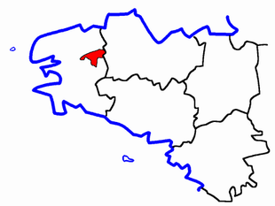
Canton of Huelgoat
| Former Canton of Huelgoat |
|
|---|---|
| region | Brittany |
| Department | Finistère |
| Arrondissement | Chateaulin |
| main place | Huelgoat |
| Dissolution date | March 29, 2015 |
| Residents | 5,364 (Jan 1, 2012) |
| Population density | 21 inhabitants / km² |
| surface | 260 km² |
| Communities | 8th |
| INSEE code | 2916 |
The canton Huelgoat was 2015 a French constituency in Arrondissement Châteaulin , in the Finistere region and in the region of Brittany ; its main town was Huelgoat .
location
Communities
The canton of Huelgoat consisted of eight municipalities:
| local community | Breton | Population (2017) |
Area (km²) |
Code postal | Code Insee |
|---|---|---|---|---|---|
| Berrien | Berrien | 919 | 56.42 | 29690 | 29007 |
| Bolazec | Bolazeg | 205 | 17.47 | 29640 | 29012 |
| Botmeur | Boneur | 215 | 13.62 | 29690 | 29013 |
| Huelgoat | To Uhelgoad | 1,449 | 14.87 | 29690 | 29081 |
| La Feuillée | Ar Fouilhez | 641 | 31.55 | 29690 | 29054 |
| Locmaria-Berrien | Lokmaria Berrien | 231 | 17.20 | 29690 | 29129 |
| Plouyé | Plouie | 674 | 37.55 | 29690 | 29211 |
| Scrignac | Skigneg | 757 | 70.94 | 29640 | 29275 |
| Canton | To Uhelgoad | 5,364 | 259.62 | - | 2916 |
Population development
| 1962 | 1968 | 1975 | 1982 | 1990 | 1999 | 2006 | 2012 |
|---|---|---|---|---|---|---|---|
| 8,886 | 8,361 | 7,308 | 6,509 | 5,739 | 5,486 | 5,410 | 5,364 |
