
Cape Arkona
| Cape Arkona | ||
 Cape Arkona from the northwest (2007) |
||
| Geographical location | ||
|
||
| Coordinates | 54 ° 40 '35 " N , 13 ° 26' 16" E | |
| Waters 1 | Baltic Sea | |
 Cape Arkona from the south (2012) |
||

Cape Arkona is a 43 meter high cliff consisting of chalk and marl boulder on the Wittow peninsula in the north of the island of Rügen . The area monument Kap Arkona belongs next to the fishing village Vitt to the municipality Putgarten and is one of the most popular excursion destinations on Rügen with around 800,000 visitors annually.
At the cape there are two lighthouses , a former naval bearing tower , two former military bunkers, the Slavic Jaromarsburg , a weather station of the German Weather Service and some tourist buildings (restaurants, bars, souvenir shops). Due to the geological nature and the weather influences, there are often large bank breaks at the Cape, mainly in winter and spring.
Cape Arkona is often referred to as the “northernmost point of Rügen”, but this is not true. About a kilometer to the northwest is a point on the cliff called Gellort , which is a little further north. Directly at the foot of the Gellort lies the 165-ton boulder Siebenschneiderstein , in Low German Söbenschniedersteen . The cape offers an impressive sight of the island, both from land and from water.
geography
climate
The climate of Cape Arkona corresponds to the Mecklenburg-Western Pomerania coastal climate. The annual mean temperature is 7.9 ° C. Cape Arkona has in some years, including 2013 (with 1,950.2 hours of sunshine), the longest duration of sunshine of all the German Weather Service operated weather stations . The precipitation amounts to 521 mm per year. The average humidity is very high due to the sea location.
| Arkona | ||||||||||||||||||||||||||||||||||||||||||||||||
|---|---|---|---|---|---|---|---|---|---|---|---|---|---|---|---|---|---|---|---|---|---|---|---|---|---|---|---|---|---|---|---|---|---|---|---|---|---|---|---|---|---|---|---|---|---|---|---|---|
| Climate diagram | ||||||||||||||||||||||||||||||||||||||||||||||||
| ||||||||||||||||||||||||||||||||||||||||||||||||
|
Monthly average temperatures and rainfall for Arkona
Source: wetterkontor.de
|
|||||||||||||||||||||||||||||||||||||||||||||||||||||||||||||||||||||||||||||||||||||||||||||||||||||||||||||||||||||||||||||||||||||||||||||||||||||||||||||||||||||
Attractions
Jaromarsburg
_3.JPG)
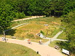
From the 9th to the 12th century, the Jaromarsburg was a cult site of the Ranen , a Slavic tribe, dedicated to their god Swantewit . Located at the extreme tip of the cape, it was protected on three sides by the steep coast and on the land side by a 25-meter-high rampart .
The temple located within the wall took over after the destruction of Rethra in 1068 its importance as the religious center of the Slavs of Mecklenburg . In 1168 the Danish King Waldemar I conquered the castle complex in the course of Christianization and destroyed the temple.
Parts of the tip of Arkona have repeatedly plunged into the sea in recent centuries, which is why almost only the ramparts of the Jaromarsburg are visible today.
Königstreppe and violet stairs

A few meters west of Cape Arkona is the Königstreppe, which overcomes 42 meters of steep coast with 230 steps. The Swedish King Friedrich I - Rügen was part of Sweden at the time - had a fire beacon erected near today's stairs to warn the population during the Swedish-Russian War 1741–1743 . At that time the place was still called Königssteig .
For the reception of the steam boat Hercules with the imperial-Russian chronometer expedition, the Prussian King Friedrich Wilhelm III. - Rügen was now Prussian - 1833 build a pier and a staircase. From here the first telegraph cable was laid through the Baltic Sea to Sweden in 1865 . With the boom in the Rügen seaside resorts, tourism at Cape Arkona also increased. Many travelers came with excursion steamers, which moored at the pier at the foot of the stairs. However, the pier was completely destroyed in the 1953 storm surge . The new Königstreppe was completed in 1995 on a historic site after a year of construction. Since December 2012, the Königstreppe has been closed after severe cliff erosion.
To the south of the remains of the Jaromarsburg wall is the violet staircase, a descent to the beach section between Arkona and Vitt. The staircase takes its name from the violets that grow around the staircase in spring.
Lighthouses and bearing tower
_10.JPG)


Bearing tower


The smaller of the two lighthouses was built in brick in 1826/27 according to plans by Karl Friedrich Schinkel and put into operation in 1828. It is 19.3 m high and has a fire height of 60 m above sea level. NN . The rooms of the three-story tower were used as service and storage rooms. It is also called the Schinkelturm . He was decommissioned on March 31, 1905. It is the second oldest lighthouse on the German Baltic coast after the Travemünde lighthouse .
The larger tower was built in 1901/02 right next to the old tower and put into operation on April 1, 1905. It is 35 m high and has a fire height of 75 m above sea level. NN . It is made of bricks and stands on an octagonal granite base. The lighting device consisted of two carbon arc lamps for 90 years and was replaced by a metal halide lamp in 1995 . Through it and the rotating triple optics, the lantern of the tower sends out three flashes every 17 seconds.

The former naval bearing tower was built in brick in 1927 and was used to monitor radio traffic on the southern Baltic Sea until the end of the Second World War. By 1945 at the latest, the technical facilities in the bearing tower were removed or destroyed and the tower deteriorated into ruins, even if it was temporarily used as an antenna carrier. It was not extensively renovated until 1996.
All three towers were renovated in the early 1990s and are open to visitors. In the old lighthouse there is now a museum and a branch of the registry office. Marriages concluded here can be immortalized on request by a small plaque in the floor in front of the tower. The bearing tower is used for exhibitions. There are viewing platforms on each tower, from which one has an unobstructed view over Rügen and especially the Wittow peninsula. When the weather is clear you can even see the Danish island of Møn .
Bunker at Cape Arkona

Entrance to the NVA bunker
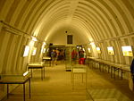
Exhibition in the NVA bunker
View of the Wehrmacht bunker from the Schinkelturm


There are two bunkers in the immediate vicinity of the two lighthouses . The smaller, older bunker dates from the times of the Wehrmacht and housed an office of the 6th Coastal Border Brigade during the GDR era . It is commonly referred to as the Arkona bunker .
The larger, newer bunker was built from 1979 to 1986 and served as a command post for the 6th Flotilla of the People's Navy and the United Baltic Sea Fleet (VOF) stationed on the bow . Starting from a main aisle with two entrances, there are several self-sufficient individual bunkers with a total area of 2000 m². Specifically, these are three large bunkers (type FB-75 ) and nine small (type FB-3 ), which were made from precast concrete parts (FB = precast bunker ). The type FB 75 bunker had a mezzanine floor on which the sleeping places were accommodated, as well as an emergency exit. Each individual bunker has one or two air locks on the main corridor . Above everything is a 3 to 5 meter high earth cover, from which dozens of ventilation pipes protrude.
In 1985, on the 30th anniversary of the National People's Army (NVA), an aerial photo of Cape Arkona with the bunker construction site in the background was shown in the photo book "Soldiers of the People" and the bunker thus exposed ( exposed means that the location of the bunker was made public) . It is not clear how the picture got into the illustrated book, but it was withdrawn from circulation three days after it was published. A later new edition of the illustrated book no longer contained the aerial photo.
From 1986, 50 to 70 soldiers of the People's Navy did their duty here three to four times a year as part of fleet maneuvers for two to three days. The standard workforce was four. On October 3, 1990, the day of German reunification , the plant was shut down.
The bunkers were acquired by the Putgarten community and gradually renovated. The Arkona bunker now houses an art gallery and the NVA bunker an exhibition with former bunker furnishings and a photo series about the People's Navy.
Directions
There is a large parking lot in front of the Putgarten community, where all cars and buses must be parked. From there you can get to the Cape either on foot (1.8 km), by horse-drawn carriage or by Cape Arkona Railway . The sights can also be easily reached by bike.
The Cape Arkona Railway has been running from Putgarten to Cape Arkona or the fishing village of Vitt since 1993. It doesn't drive - as the name suggests - on rails, but on wheels on normal roads. The towing vehicles, which look like steam locomotives , have been running on environmentally friendly gas engines since 1996 .
From July to September a ship of the shipping company Adler- Schiff operates three times a week from Binz and Sassnitz to Cape Arkona.

Ship to Cape Arkona

Arkona-Bahn in Putgarten


Others
The following ships were on the cliff baptized :
- of 1907 in Hamburg from the stack overflowed luxury liner Cap Arcona , who after the First World War in France was held, under the new name Angers drove and 1939 when scrapping burned;
- the luxury steamer Cap Arcona , launched in Hamburg in 1927 , which was sunk by the Royal Air Force at the end of the Second World War ; thousands of concentration camp prisoners were killed;
- the cargo ship Kap Arkona of the German shipping company Rostock (DSR).
- The cruise ship Saga Pearl II, launched in 1980 under the name Astor (on which The Dream Ship was filmed in 1983/84 ), was called Arkona since it was commissioned by the German shipping company (originally the GDR ) from 1985 to 2002 .
- As Arkonaplatz to the Cape named, (temporarily) in Sassnitz stationed (complaints) vessels were a 1953 -built motor lifeboat and in each case a 1974 or 1992 overflowed from the stack Seenotkreuzer the sea rescue services the GDR or DGzRS .
- The multi-purpose ship Arkona, launched in 2004 and home to Stralsund , is used by the Stralsund Waterways and Shipping Authority .
- The Imperial Navy sent an SMS Arkona launched in 1858 , 1885 and 1902 respectively .
On Christmas Day 2011, there was a major slide of debris directly at Cape Arkona, which buried a ten-year-old girl and seriously injured her mother. The week-long search for the child was abandoned by the search parties on January 8, 2012, before the child's body was found at the foot of the cape on January 31, 2012.

Steep coast south of the Jaromarsburg

View of the fishing village Vitt and Cape

Siebenschneiderstein, an ice age boulder

Arkonahof

Svantovit statue


Trivia
A concert work for wind orchestra, composed by Alfred Bösendorfer and published by Rundel- Verlag in 2002, is entitled Kap Arkona - Eine Piraten-Legende . In addition to the Störtebeker story, the Jaromarsburg is also discussed here.
literature
- Stefan Best: Secret bunker systems of the GDR. Motorbuch-Verlag, Stuttgart 2003, ISBN 3-613-02332-6 .
- Peter Feist: The castle wall at Cape Arkona (= the historical place. H. 1 Mecklenburg-Western Pomerania, Rügen ). K-und-K-Kunsthandel, Kai Homilius Verlag Berlin 1995, ISBN 3-931121-00-3 .
- Günter Krieg: The Arkona area monument . Series of publications by the Wieker Heimatverein e. V. 2001.
Web links
- kap-arkona.de Kap Arkona website of the Putgarten community
- Literature about Cape Arkona in the state bibliography MV
- The Guard Vogteien Wîtov / Wittow and Jâsmund / Jasmund website with information about Arkona
Single receipts
- ↑ Federal Statistical Office (ed.): Statistisches Jahrbuch 2014 , p. 18.
- ↑ Torsten Kempke: Scandinavian-Slavic contacts on the southern Baltic coast in the 7th to 9th centuries . In: Ole Harck, Christian Lübke (ed.): Between Reric and Bornhöved. The relations between the Danes and their Slavic neighbors from the 9th to the 13th century (= research on the history and culture of Eastern Central Europe, vol. 11), Franz Steiner Verlag, Stuttgart 2000. ISBN 3-515-07671-9 . Pp. 9–22, here p. 14. Recently also on the dating of the Slavic conquest of Rügen: Heike Reimann, Fred Ruchhöft, Cornelia Willich: Rügen im Mittelalter. An interdisciplinary study of medieval settlement on Rügen (= research on the history and culture of Eastern Central Europe, vol. 36), Franz Steiner Verlag, Stuttgart 2011. ISBN 978-3-515-09441-2 . here the chapter The beginnings of the Slavic settlement on Rügen and the oldest traditions of the name of the Rügen Slavs , pp. 42–54.
- ^ The Imperial Russian Chronometer Expedition in the Baltic Sea between Pulkowa, Moscow and Warsaw in 1833
- ↑ https://www.rundel.de/de/kap_arkona/a-259/1910 . Retrieved December 12, 2018.