
Kastl (near Kemnath)
| coat of arms | Germany map | |
|---|---|---|

|
Coordinates: 49 ° 50 ' N , 11 ° 54' E |
|
| Basic data | ||
| State : | Bavaria | |
| Administrative region : | Upper Palatinate | |
| County : | Tirschenreuth | |
| Management Community : | Kemnath | |
| Height : | 450 m above sea level NHN | |
| Area : | 24.75 km 2 | |
| Residents: | 1410 (Dec. 31, 2019) | |
| Population density : | 57 inhabitants per km 2 | |
| Postal code : | 95506 | |
| Area code : | 09642 | |
| License plate : | TIR, KEM | |
| Community key : | 09 3 77 128 | |
| Community structure: | 13 districts | |
| Address of the municipal administration: |
Kirchplatz 5 95506 Kastl |
|
| Website : | ||
| Mayor : | Hans Walter ( CSU ) | |
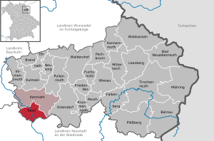
| Location of the municipality of Kastl in the Tirschenreuth district | ||
  |
||

Kastl is a municipality in the Upper Palatinate district of Tirschenreuth and a member of the Kemnath administrative community .
geography
The landscape at the foot of the Rauhen Kulm , traversed by the Haidenaab , with its extensive forests offers a variety of hiking opportunities.
Local division
Kastl has 13 districts:


history
Kastl belonged to the Amberg Rent Office and the Waldeck Regional Court of the Electorate of Bavaria .
A historical highlight of the village was the battle it won against a French troop on August 26th, 1796. The Chancellor farmers only used pitchforks to counter the French, who were armed with firearms, and were thus able to prevent them from attacking the neighboring town of Kemnath. This was only possible because the soldiers had drunk a lot the night before.
Surname
The place name "Kastl" occurs several times in Bavaria. The historical atlas of Bavaria, Volume Kemnath, describes the following spelling variants from 1244 to 1747: "Chasten", "Kastel", "Castel" and "Castl". There are different original forms for the place name Kastl, such as B .: "Box" = storage (cf. mailbox, clothes box, granary or box) "Castell" = fortress, bulwark, castle, refuge "Castulus" = Roman martyr, whose bones were initially in Moosburg and later transferred to Landshut .
The original distribution area of this place name used to be much larger. In the course of the territorial reforms, many wastelands , hamlets or mills have given up their original names and adopted that of the larger community. For the place Kastl (near Kemnath) only the derivation of "memory" from the original words listed above comes into question. This goes back to a regulation according to which civil servants and servants used to be allocated land from the community or from the manor and demanded a grain interest for it, i.e. a kind of tax in kind. This required a storage location, a storage facility or "box" that was managed by the "box office" (today: tax office). Due to the remarkable size of the parish Kastl in the Middle Ages and the fact that it belonged to the lords of Waldeck and Leuchtenberg as well as the nearby Speinshart monastery, there was such a "grain box" in the village. In the Salbuch from 1283 the “Schlössl” (house no. 17) is called, on the foundation walls of which today's “Löindlhaus” is located. Cellar vaults and wells are still there.
In addition to the different place names, which are formed from the above word stem , such as “St. Kastl ”or“ Markt Kastl ”(near Amberg) are also derived from numerous family names, such as B. "Kastner", a name that is widespread in the region around Kastl.
Incorporations
In 1945 or 1946 the previously independent community Wolframshof was incorporated. On January 1, 1972, Unterbruck was added. On January 1, 1978, part of the dissolved community of Löschwitz was incorporated.
Population development
As one of four communities in the Tirschenreuth district, Kastl was able to report an increase in population in 2004 and had 1398 residents. Kastl also has the largest proportion of minors in the entire district.
Between 1988 and 2018, the population rose from 1244 to 1399 by 155 or 12.5%, which was the highest percentage increase in the district in the period mentioned.
Buildings
In the districts of Wolframshof and Unterbruck there are two castles with large associated lands (agricultural areas and wooded areas). Another building is the St. Margaretha Church in the center of the village. There is a so-called Boniface stone each in the cemetery and in Wolframshof Castle. Bonifatius had such stones set up wherever he was missionary as a sign of his work.
See also: List of architectural monuments in Kastl (near Kemnath)
particularities
The village of Kastl was the district winner in 2005 in the competition Our village should be more beautiful - our village has a future .
Politics and culture
Municipal council
As of May 1, 2020
mayor
First Mayor is Hans Walter , Second Mayor Michaela Veigl. Both belong to the CSU.
coat of arms
Blazon: In red under a silver shield head, inside two red wheel crosses connected with a horizontal red bar, above a silver shield, inside a blue bar, two silver dragon wings. The coat of arms has been used since 1982.
societies
The largest sports club in the municipality is the TSV 1960 Kastl with the divisions football, volleyball, tennis, table tennis, skiing, hiking and several gymnastics groups. There is also the Unity Hubertus Kastl shooting club . He owns one of the most modern shooting sports facilities in Europe. The youth work is very successful with four world championship titles, one European champion and several title winners at national level (German and Bavarian champions).
Culture
The Kastl cultural meeting place with 940 people has most members of all associations . The Kastler Cabaret Days are the cultural highlight of every year. Several cabaret artists and singers, mostly known from television, always take part in the event. The rock band Troglauer Buam lives partly in Kastl, and their eponymous rehearsal room Muhbarack in Troglau is also located in the southern municipality.
Thanksgiving procession
There has been a historic Thanksgiving procession in Kastl since 1950. During the pageant, which only takes place every ten years, rural life is presented as it once was. The list of floats is long: from the farmer's wedding, the team of horses with a loaded hay wagon, a school class with a teacher to the Hutza-Stub'n, everything is there. Over 30 floats and numerous groups of feet represent life in the country as identically as possible. All associations of the Kastl parish with almost 500 participants take part in the procession. The pageant in 2000 attracted over 8,000 visitors.
American settlement
Since the beginning of 2005 the municipality of Kastl has also had 40 US citizens. The houses built as part of the expansion of the Grafenwoehr military training area are not far from the center of the village and form an "American quarter".
economy
Established businesses
The largest employers in the area are the company IEM Fördertechnik GmbH (conveyor belts, conveyor systems), which delivers to Brazil and India, the construction company Johann Heining and the company Heinrich Hoven.
Services and establishments
In the municipality of Kastl there is a primary school, a kindergarten, a Catholic church, several banks and insurance companies, several inns, a café, hairdressers, general practitioner, dentist, physiotherapy, massage practice, bakery, butcher, advertising agency, painting company, roofing company, construction company, a volunteer Fire brigade, electrical shop and sawmill.
Transport links
Kastl is conveniently located in the city triangle of Bayreuth, Weiden, Marktredwitz and has a direct connection with the state road 2665 to the B 22 and B 299 and thus also to the A 9 and A 93 motorways .
nature
Web links
- Aerial photos of the place
- Entry on the coat of arms of Kastl (near Kemnath) in the database of the House of Bavarian History
- Culture meeting place Kastl
- Thanksgiving procession
- Kastl (near Kemnath): Official statistics of the LfStat
Individual evidence
- ↑ "Data 2" sheet, Statistical Report A1200C 202041 Population of the municipalities, districts and administrative districts 1st quarter 2020 (population based on the 2011 census) ( help ).
- ↑ http://www.bayerische-landesbibliothek-online.de/orte/ortssuche_action.html ? Anzeige=voll&modus=automat&tempus=+20111108/091341&attr=OBJ&val= 1083
- ^ Wilhelm Volkert (ed.): Handbook of Bavarian offices, communities and courts 1799–1980 . CH Beck, Munich 1983, ISBN 3-406-09669-7 , p. 495 .
- ^ Federal Statistical Office (ed.): Historical municipality directory for the Federal Republic of Germany. Name, border and key number changes in municipalities, counties and administrative districts from May 27, 1970 to December 31, 1982 . W. Kohlhammer GmbH, Stuttgart / Mainz 1983, ISBN 3-17-003263-1 , p. 663 .

Bad Neualbenreuth | Bärnau | Fire | Ebnath | Erbendorf | Falkenberg | Friedenfels | Fuchsmühl | Immenreuth | Kastl | Kemnath | Konnersreuth | Krummennaab | Kulmain | Leonberg | Mähring | Mitterteich | Neusorg | Pechbrunn | Plößberg | Pullenreuth | Reuth near Erbendorf | Tirschenreuth | Waldershof | Waldsassen | Wiesau