Klobuky
| Klobuky | ||||
|---|---|---|---|---|
|
||||
| Basic data | ||||
| State : |
|
|||
| Region : | Středočeský kraj | |||
| District : | Kladno | |||
| Area : | 1587 ha | |||
| Geographic location : | 50 ° 18 ' N , 13 ° 59' E | |||
| Height: | 262 m nm | |||
| Residents : | 1,009 (Jan 1, 2019) | |||
| Postal code : | 273 74 | |||
| License plate : | S. | |||
| traffic | ||||
| Street: | Peruc - Třebíz | |||
| Railway connection: | Prague - Most | |||
| structure | ||||
| Status: | local community | |||
| Districts: | 5 | |||
| administration | ||||
| Mayor : | Soňa Ottová (as of 2015) | |||
| Address: | 9. května 62 273 74 Klobuky v Čechách |
|||
| Municipality number: | 532461 | |||
| Website : | klobuky.cz | |||
| Location of Klobuky in the Kladno district | ||||

|
||||
Klobuky (German hat , formerly also Klobuk ) is a municipality in the Czech Republic . It is located nine kilometers northwest of Slaný and belongs to the Okres Kladno .
geography
Klobuky is located in the Central Bohemian Table Country at the confluence of the Zlonický potok in the Žerotínský potok. The railway runs through the town from Prague to Most . The Petrified Shepherd stands north of Peruc near the road to Telce. In the south is the Cukrovarský rybnik pond.
Neighboring towns are Vrbičany in the north, Čeradice and Moráň in the east, Kobylníky in the southeast, Třebíz in the south, Hořešovice and Hořešovičky in the southwest, Pacov and Kokovice in the west and Telce in the northwest.
history
Klobuky was first mentioned in 1226 as the property of the Doxan Monastery . At the beginning of the 14th century the town was divided, with the St. Vitus Cathedral Chapter in Prague holding a share . The other belonged to the country nobles who built a fortress in Klobuky. In 1352 the parish church was first mentioned in a papal register. The place was a Vladikensitz since 1355 . The owners of the secular part included u. a. the lords of Bražkov and Lukov, who owned Klobuky from 1388.
During the Hussite Wars, the village near the Kalixtine stronghold of Slaný became Hussite. Recatholization took place in 1669. In 1848, Klobouky became an independent municipality in the Slaný district, to which the village of Kobylníky belonged. At the end of the 19th century a major sugar factory was built. In 1961 the communities Kokovice and Páleček were incorporated with the district Čeradice.
Community structure
The municipality of Klobuky consists of the districts Čeradice ( Tscheraditz ), Klobuky ( Hut ), Kobylníky ( Kobilnik ), Kokovice ( Kokowitz ) and Páleček ( Klein Paletsch ) as well as the one-layer Moráň.
Attractions
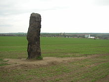
- The Petrified Shepherd (Zkamenělý pastýř), also Stone Man (Kamenný muž) is a menhir that was probably erected in Celtic times. The 3.50 m high rock made of brown-gray sandstone stands north of the village
- Church of St. Laurentius in Klobuky, the church located on a hill above the village and verifiable since 1352, received its present form during the renovation between 1729 and 1736
- Church of the Visitation of the Virgin Mary in Páleček, built in 1776, the building is currently in a neglected state
Personalities
- Jindřich Šimon Baar worked as a chaplain in Klobuky, he had a new rectory built
- The graveyard of the Malypetr family is located in the cemetery, it is the final resting place of the Czechoslovak Prime Minister Jan Malypetr (1873-1947) and his father, the co-founder of the Sokol movement, Josef Malypetr (1828-1900)
- The poet Karel Toman was born in Kokovice
- The Slovak poet Ivan Basko worked as a chemist in the sugar factory.
Web links
- http://www.kokovice.estranky.cz/ (website about the district of Kokovice)


