
Velvary
| Velvary | |||||
|---|---|---|---|---|---|
|
|||||
| Basic data | |||||
| State : |
|
||||
| Region : | Středočeský kraj | ||||
| District : | Kladno | ||||
| Area : | 1809 ha | ||||
| Geographic location : | 50 ° 17 ' N , 14 ° 14' E | ||||
| Height: | 188 m nm | ||||
| Residents : | 3,044 (Jan 1, 2019) | ||||
| Postal code : | 273 24 | ||||
| License plate : | S. | ||||
| traffic | |||||
| Street: | Nová Ves ( D 8 ) - Slaný | ||||
| Railway connection: | Kralupy nad Vltavou – Velvary | ||||
| structure | |||||
| Status: | city | ||||
| Districts: | 4th | ||||
| administration | |||||
| Mayor : | Jitka Linhartová (as of 2009) | ||||
| Address: | náměstí Krále Vladislava 1 273 24 Velvary |
||||
| Municipality number: | 533041 | ||||
| Website : | www.velvary.cz | ||||
| Location of Velvary in the Kladno district | |||||

|
|||||


Velvary (German Welwarn , older Welbern ) is a city in the Czech Republic . It is located seven kilometers northwest of Kralupy nad Vltavou and belongs to the Okres Kladno .
geography
Velvary is located on the left side of the Vltava valley in the North Bohemian Tableland. The city lies on the right bank of the Bakovský potok at the confluences of the Červený potok and the Svodnice. In the south Velvary is bypassed by the state road I / 16 between the motorway exit 18 of the D 8 at Nová Ves and Slaný . The town is the terminus of the Kralupy nad Vltavou – Velvary railway line .
Neighboring towns are Miletice and Dolni Kamenice in the north, Budihostice and Chržín in the Northeast, Uhy the east, Hleďsebe 1. díl, Radovic and Nelahozeves in the southeast, Velká Bučina, Olovnice and Neuměřice in the south, Kamenný Most , Nový Mlýn and Ješín in the southwest, Hobšovice , Podhorní Mlýn, Nabdín and Bratkovice in the west and Hospozín and Černuc in the northwest.
history
Velvary was built on an important trade route from Prague to the Meissen region . The first written mention of the village belonging to the Prague Collegiate Chapter took place in 1282. Charles IV raised Velvary in 1357 to a town. In 1482 Wladislaw Jagiello made Velvary a royal city . The city, which was laid out around a rectangular market square, was fortified and had four city gates. Efforts to subordinate the city to the Upper Castle Count of Prague were unsuccessful in the 16th century. In 1593 Rudolf II confirmed Velvary as a royal city. Although the city suffered no destruction during the Thirty Years' War, it became deserted.
Until the middle of the 19th century, Velvary was always one of the Bohemian chamber estates . The Teplitzer Kaiserstraße made until the start of rail transport the most important connection between Prague and Dresden . The trend of this time was also the demolition of narrow city fortifications, the purpose of which was no longer given. The Raudnitzer Tor was demolished in 1841, the Schlaner Tor in 1878 and the Chržín Tor also fell in the 19th century.
After the abolition of patrimonial Velvary became the seat of a judicial district from 1848 and from 1850 belonged to the district administration Slaný. The relocation of the traffic routes to Saxony in the Elbe valley led Velvary to sideline. It was not until 1882 that Velvary was connected to the railway network by a local railway from Kralupp . Since 1921 the town belonged to the Okres Kralupy nad Vltavou and after its dissolution in 1960 it was assigned to the Okres Kladno . In 1961 Velká Bučina was incorporated (with Malá Bučina) and in 1980 Ješín was added. Because of the numerous historical buildings, the center of Velvary has been declared an urban monument reserve.
City structure
The town of Velvary consists of the districts Ješín ( Jeschin ), Malá Bučina ( Klein Butschin ), Velká Bučina ( Groß Butschin ) and Velvary ( Welwarn ) as well as the settlements Nové Uhy ( Neu Uha ) and Radovič ( Radowitz ).
sons and daughters of the town
- Jan Antonín Koželuh (1738–1814), composer
- Leopold Koželuh (1747–1818), composer and music teacher
- Václav Klement (1868–1938), automobile manufacturer
- Ferdinand Stiebitz (1894–1961), classical philologist and translator
Attractions
- Deanery Church of St. Katharinen, the Gothic building dates from the 14th century
- St. Georg cemetery church, built 1613–1616, the last Protestant church building in Bohemia before re-Catholicization
- hospital
- stately inn, today the city library
- Town hall, baroque building from 1714
- city Museum
- Statue of St. John of Nepomuk
- All Saints Chapel
- Plague column on the market, created 1716–1719
- Prague Gate, Renaissance building from 1580
- Chapel of St. Trinity, built on the Trinity Fountain near Radovič
- Half-wooden bell tower
- Former synagogue , built in 1930

Market place from the east

House No. 57 on the market square (around 1600)
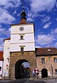
Prague gate
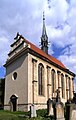
St. Georg cemetery church


Web links
Individual evidence
- ↑ Český statistický úřad - The population of the Czech municipalities as of January 1, 2019 (PDF; 7.4 MiB)
- ↑ Archived copy ( Memento of the original dated December 7, 2016 in the Internet Archive ) Info: The archive link was inserted automatically and has not yet been checked. Please check the original and archive link according to the instructions and then remove this notice.