
Cake (community)
| coat of arms | Germany map | |
|---|---|---|

|
Coordinates: 48 ° 38 ' N , 9 ° 48' E |
|
| Basic data | ||
| State : | Baden-Württemberg | |
| Administrative region : | Stuttgart | |
| County : | Goeppingen | |
| Height : | 407 m above sea level NHN | |
| Area : | 8.95 km 2 | |
| Residents: | 5658 (December 31, 2018) | |
| Population density : | 632 inhabitants per km 2 | |
| Postal code : | 73329 | |
| Area code : | 07331 | |
| License plate : | GP | |
| Community key : | 08 1 17 033 | |
| Address of the municipal administration: |
Marktplatz 11 73329 Cake |
|
| Website : | ||
| Mayor : | Bernd Roessner | |
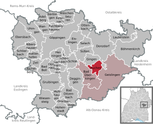
| Location of the community in the district of Göppingen | ||
  |
||

Kuchen is a municipality in Baden-Württemberg that belongs to the district of Göppingen .
geography
Geographical location
The municipality of Kuchen is 386 to 720 m above sea level. Meters above sea level in the inner step edge bay of the Fils , which here after its easternmost point near Geislingen slowly turns on its west course in the foothills of the Alb. It encompasses the wide valley floor of the river, where the eponymous village, as the crow flies, about 13 km southeast of the district town of Göppingen , with its settlement core at about 407 m above sea level. NN is to the left of the river, as well as the wide valley slopes up to the upper bend in the slope, on the left side of the northwest running valley axis also smaller foothills of the Swabian Alb .
Neighboring communities
Neighboring communities are in turn the community of Gingen an der Fils in the north-west, the cities of Donzdorf in the north-east and Geislingen an der Steige in the south-east and the community of Bad Überkingen in the south-west, all of which, like Kuchen itself, belong to the Göppingen district.
Community structure
Cake includes the village of Kuchen and the house of the South German Cotton Industry as well as the abandoned villages of Spitzenberg (Burg), Böldlinshof and Seelhofen.
Division of space

According to data from the State Statistical Office , as of 2014.
history

The first traces of human settlement date from the Urnfield period (from 1200 BC to 800 BC). Traces of Roman settlement have not yet become known, but archaeological finds confirm a Merovingian burial field north of the Fils. Find reports that possibly prove a second burial ground near the place south of the Fils are unclear. The place name cake could be related to iron smelting, which produces cake-shaped slag. Corresponding finds exist in neighboring Altenstadt ( Geislingen ).
However, the facility of Spitzenberg Castle , which may legally be regarded as the successor to the Hunnenburg ramparts , became important for the development of Kuchen . Their dating is so far unclear (explanatory finds of illegal excavations have disappeared in private property). Cake was laid out as a planned city. The historical floor plan, which has become unclear today due to the main road and new buildings, reveals the former city complex. Until a few years ago, the remains of a fortification with ramparts and ditches were still visible. The Jakobuskirche is located off the main axis. There walled relief foils come from an earlier church building, but have nothing to do with a Germanic sanctuary postulated earlier.

Cake was first mentioned as Cuchin in a document in 1228 . At that time it was under the control of the Counts of Helfenstein . Market law has been handed down since 1356 . In 1396 the place came under the rule of the Free Imperial City of Ulm . Cake came to Bavaria in 1806 after mediatization on the basis of the Reichsdeputationshauptschluss conclusion , but due to an exchange of territory it was transferred to Württemberg in 1810 . There it was assigned to the Oberamt Geislingen .
In 1938, the community of Kuchen came to the district of Göppingen .
Religions
With the introduction of the Reformation in Ulm, Kuchen also became Protestant in 1531 . For a long time there was no longer a Roman Catholic population in the village, but the influx of displaced people after the Second World War almost made the number of Catholics almost equal to that of Protestants. At the end of 2017, 1901 inhabitants were Protestant, 1821 Catholic and 1925 belonged to other religious communities or did not provide any information
Population development
Source: Baden-Württemberg State Statistical Office for data from 1970
| date | Residents |
|---|---|
| 1837 | 1062 |
| 1907 | 2113 |
| May 17, 1939 | 2506 |
| September 13, 1950 | 3698 |
| May 27, 1970 | 5335 |
| December 31, 1983 | 5560 |
| May 25, 1987 | 5567 |
| December 31, 1991 | 5818 |
| December 31, 1995 | 5709 |
| December 31, 2005 | 5723 |
| December 31, 2010 | 5512 |
| December 31, 2015 | 5520 |
politics
coat of arms
Blazon : "Divided by red and silver, on top of a golden four-mountain a striding silver elephant, below a gold-studded red rose with green sepals."
While the elephant is reminiscent of the Counts of Helfenstein , the rose comes from the city arms of Geislingen.
The white and red flag of the place was awarded on February 16, 1959 by the Ministry of the Interior.
Municipal council
The municipal council in Kuchen has 18 members. The local election on May 26, 2019 led to the following official final result. The municipal council consists of the elected voluntary councilors and the mayor as chairman. The mayor is entitled to vote in the municipal council.
| Parties and constituencies |
% 2019 |
Seats 2019 |
% 2014 |
Seats 2014 |
||
| CDU | Christian Democratic Union of Germany | 34.20 | 6th | 35.45 | 6th | |
| FWV | Free voter association cake | 30.78 | 5 | 31.47 | 6th | |
| SPD | Social Democratic Party of Germany | 26.07 | 5 | 28.11 | 5 | |
| GREEN | Alliance 90 / The Greens | 8.95 | 2 | 4.97 | 1 | |
| total | 100.0 | 18th | 100.0 | 18th | ||
| voter turnout | 57.5% | 52.28% | ||||
mayor
Bernd Rößner has been the mayor since 1993 and was re-elected in 2001, 2009 and 2017.
Economy and Infrastructure
traffic
Kuchen is connected to the national rail network by the Filstalbahn ( Stuttgart –Ulm).
The federal highway 10 Stuttgart – Ulm runs through the municipality .
Educational institutions
With the Gottfried von Spitzenberg School , Kuchen has a primary and secondary school with a technical secondary school . In addition to the municipality's own kindergartens - SBI kindergarten in the former workers' settlement and kindergarten in Kirchgasse - there is also a Roman Catholic kindergarten and a Protestant kindergarten.
Culture and sights

building
- The Jakobuskirche
- Spitzberg Castle
- The historic workers' settlement in Kuchen was built by the then owner of the country's largest cotton spinning and weaving mill for their workers from 1857 to 1869. For the times, it was equipped with exemplary and progressive cultural, leisure, supply and health facilities. After the bankruptcy of the company Süddeutscheotton Industrie AG Kuchen (SBI), part of the estate was redeveloped from 1987 for approx. 20 million DM .
Sports
There are two major sports clubs in Kuchen:
- the gymnastics and sports club Kuchen 1872 eV
- and the FTSV (Free Gymnastics and Sports Association).
Sons and daughters of the church
- Nikolaus Bantleon (1838–1928), farmer, member of the Reichstag
- Christin-Désirée Rudolph (* 1966), writer
Web links
Individual evidence
- ↑ State Statistical Office Baden-Württemberg - Population by nationality and gender on December 31, 2018 (CSV file) ( help on this ).
- ^ The state of Baden-Württemberg. Official description by district and municipality. Volume III: Stuttgart District, Middle Neckar Regional Association. Kohlhammer, Stuttgart 1978, ISBN 3-17-004758-2 . Pp. 320-321
- ↑ State Statistical Office, area since 1988 according to actual use for cakes.
- ↑ Municipality of Kuchen Figures Data Facts , accessed on January 18, 2020
- ↑ Eberhard Gönner and Heinz Baruda: "Wappenbuch des Landkreises Göppingen" , published by the Landkreis Göppingen and the Stuttgart Archive Directorate, Verlag W. Kohlhammer, Stuttgart 1966
- ↑ Election information for the municipal data center
- ↑ Bernd Rößner remains mayor in Kuchen Südwest Presse April 10, 2017
- ^ "Historical workers' settlement" on the website of the parish of Kuchen

Adelberg | Aichelberg | Albershausen | Bad Boll | Bad Ditzenbach | Bad Ueberkingen | Birenbach | Böhmenkirch | Börtlingen | Deggingen | Donzdorf | Drackenstein | Dürnau | Ebersbach an der Fils | Eislingen / Fils | Eschenbach | Gammelshausen | Geislingen an der Steige | Went to the Fils | Göppingen | Gruibingen | Hattenhofen | Heiningen | Hohenstadt | Cake | Lauterstein | Mühlhausen im Täle | Ottenbach | Rechberghausen | Salach | Schlat | Schlierbach | Cuties | Uhingen | Cheeks | Waschenbeuren | Wiesensteig | Zell under Aichelberg