
Kaisertal
|
Kaisertal ( scattered houses ) locality |
|||
|---|---|---|---|
|
|||
| Basic data | |||
| Pole. District , state | Kufstein (KU), Tyrol | ||
| Judicial district | Kufstein | ||
| Pole. local community | Ebbs ( KG Ebbs) | ||
| Coordinates | 47 ° 34 '34 " N , 12 ° 10' 5" E | ||
| height | 820 m above sea level A. | ||
| Residents of the village | 41 (January 1, 2020) | ||
| Building status | 30 (2001) | ||
| Postcodes | 6330 Kufstein | ||
| prefix | + 43/05372 | ||
| Statistical identification | |||
| Locality code | 16653 | ||
| Counting district / district | Eichelwang -Kaisertal (70508 001) | ||
 Kaisertal from the southeast, in the foreground Hans-Berger-Haus , behind it the Anton-Karg-Haus , seen from the Hinteren Karlspitze |
|||
| Source: STAT : index of places ; BEV : GEONAM ; TIRIS | |||

|
Kaisertal ( scattered houses ) locality Kufstein-Kaisertal |
|
|---|---|
| Basic data | |
| Pole. District , state | Kufstein , Tyrol |
| Judicial district | Kufstein |
| Pole. local community | Kufstein ( KG Kufstein) |
| Coordinates | 47 ° 35 ′ 19 ″ N , 12 ° 12 ′ 14 ″ E |
| height | 702 m above sea level A. |
| Residents of the village | 2 (January 1, 2020) |
| Building status | 1 (2008) |
| Statistical identification | |
| Locality code | 16673 |
| Counting district / district | Upper suburb - Kienb. -Ost (70513 011) |
| uninhabited, coordinate at thicket chapel Source: STAT : Ortverzeichnis ; BEV : GEONAM ; TIRIS |
|
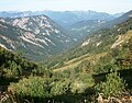
The Kaisertal (formerly Sparchental ) is a striking valley cut between the Zahmer and the Wilder Kaiser in the Tyrolean Kaiser Mountains.
In the valley there is a village in Ebbs , Kufstein district , which was without a road connection until 2008. The other, southern side of the valley without permanent settlement is a village in the city of Kufstein .
The valley has been part of the Kaisergebirge nature reserve since 1963 .
geography
The Kaisertal stretches eastwards from Kufstein in the Lower Inn Valley and separates the Wilder Kaiser in the south from the Zahmer Kaiser in the north.
The Kaiserbach (Sparchenbach) flows in the gorge (Sparchenklamm) at the bottom of the valley and flows into the Inn in the north of Kufstein. Towards the end of the valley the valley widens slightly and the Bärental branches off to the northeast, which already belongs to the Walchsee municipality . The Kaisertal itself runs against the Stripsenjoch , which separates the Wilder Kaiser from the Feldbergzug , and changes into the Kirchdorfer Kaiserbachtal . In the Kaiserbachtal the Kaisertalbach flows in an easterly direction and flows into the Kohlenbach near Griesenau .
The Kaisertal settlement
The village of Kaisertal is located on the southern slope of the Zahmer Kaiser and has about 30 inhabitants. It includes several beautiful solitary farms (Pfandlhof, Veitenhof, Hinterkaiser) , some of which have been converted into inns. The village church is the Antoniuskapelle .
The Ebbs local area includes the Alpengasthof Ritzaualm above the village, the former Alpengasthof Kaiserwacht, the huts Hans-Berger-Haus , Stripsenjochhaus and Vorderkaiserfeldenhütte , and the alpine pastures Hofinger Alm, Bodenalm, Ramstalalm near the village, the Hechleitalm into the valley, and the Stripsenalm at the eastern end of the valley the Rogeralm and the Hinterkaiserfeldenalm on the ascent to the Zahmer Kaiser.
The Thicket Chapel on the other side of the valley and the Alpengasthaus Anton-Karg-Haus belong to the Kufstein-Kaisertal area .
Neighborhoods (shared by Ebbs-Kaisertal and Kufstein-Kaisertal):
|
Oberndorf (Gem. Ebbs) Eichelwang (Gem. Ebbs) |
Oberbuchberg (Gem. Ebbs) |
Durchholzen (Gem. Walchsee ) Oed (Gem. Walchsee ) |
| Kufstein (Gem.) |
.svg)
|
Kirchdorf iT (in the Kitzbühel district ) |
| Mitterndorf (district of Kufstein) | Kufstein-Stadtberg (district of Kufstein) |
Ellmau (Gem.) Scheffau aWK (Gem.) |
Road development

Until June 1, 2008, the Kaisertal was only accessible on foot. The most frequently used access led from Eichelwang (near Ebbs ) over 285 steps on the Kaiseraufstieg into the valley. The Kaisertal was the last inhabited valley in Austria without any connection to the public road system. Motor vehicles for traffic in the Kaisertal were either transported by helicopter or (if necessary, dismantled into individual parts) via the Kaiseraufstieg. At the end of the ascent there is a plateau where the residents of the Kaisertal used to park their cars before going down almost 300 steps into the city. For years, improvements to the access to the Kaisertal were discussed, including the construction of an inclined elevator or an improved form of the existing material ropeway from Kufstein.
Road construction was only decided after variant tests and years of negotiations between the municipality of Ebbs and the city of Kufstein (largest landowner in the Kaisertal). Due to the nature reserve in the Kaisertal, Kufstein and the alpine clubs had long spoken out against road construction and offered the Kaisertalers to expand the existing cable car into Kaisertal so that vehicles could be transported with it without problems. This was rejected by the Ebbs community.
The construction of a road from Ebbs through an approximately 800 m long tunnel into the Kaisertal began in 2006 (groundbreaking on May 19, 2006). In order to meet the concerns of nature conservationists, the road is only accessible to the local residents, businesses and emergency vehicles (barriers with keys). On March 10, 2007, the tunnel broke through into the Kaisertal. The expansion of the tunnel and the roads leading to it were completed in autumn 2007, and work began on a sewer system in the valley . The tunnel was officially opened on May 31, 2008. Since the opening of the Annatunnel there has been an absolute ban on cycling in the entire Kaisertal. With the completion of the tunnel, a material cable car was dismantled with the valley station in the Kufstein district of Sparchen. The mountain station was a little below the Pfandlhof. There was a middle station in the area of the Veitenhof.
Attractions
- Thicket chapel , listed
- Klaushütte , hunting lodge, with Haupttrift -Klause (see also: Kaiserbach )
- A popular calendar motif is the Antonius Chapel on Kaisertalweg in the middle part of the valley.
- Tischofer cave
Kaisertal from the east from Stripsenjoch

Ellmauer Halt ,
main summit of the emperor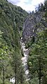
Sparchenklamm with Sparchenbach

Antoniuskapelle, view out of the valley with Pendling


As part of the ORF program 9 Places - 9 Treasures , the Kaisertal was voted the most beautiful place in Austria in October 2016.
Web links
- Kaiserreich , Maximilian Müller, Stefan Müller (www.kaisertal.info) - private website about the Kaisertal
Individual evidence
- 70508 - Ebbs. Community data, Statistics Austria .
- 70513 - Kufstein. Community data, Statistics Austria .
- ↑ a b c Access to Kaisertal opened . ORF Tirol , May 31, 2008
- ↑ There is still calm in the car-free Kaisertal . Neue Zürcher Zeitung , November 20, 2003
- ↑ Life without a road . The time , 2007
- ↑ Kleine Zeitung: "9 Places - 9 Treasures": The Tyrolean Kaisertal wins . Article dated October 26, 2016, accessed October 26, 2016.
Kaisertal (Talung): 47 ° 35 ′ 3 ″ N , 12 ° 15 ′ 57 ″ E Map with all coordinates: OSM | WikiMap
![]()

Cadastral communities: Buchberg | Ebbs
Locations: Asching | Fire | Ebbs | Acorn cheek | Kaisertal | Nutham | Oberbuchberg | Oberndorf | Wagrain-Mühltal
Villages:
Ebbs •
Oberndorf |
Hamlet:
Fürst •
Plafing •
Reisch •
Wolfing •
Wörnsbach |
Rotten:
Brand •
Nussham •
Point •
Schanz •
Wagrain |
Settlements:
Eichelwang •
Feldberg •
Mühltal •
Tafang •
Weidach |
Scattered houses:
Asching •
Kaisertal •
Oberbuchberg
Other local documents:
Antoniuskapelle •
Hans Berger Haus •
Klaus hut •
St. Nicholas •
Stripsenjochhaus •
Castle Wagrain •
Vorderkaiserfelden Hut
Counting area: Ebbs | Eichelwang - Kaisertal | Buchberg am Kaiser | Oberndorf | Weidach - Wagrain

Cadastral communities: Kufstein | Morsbach | Thierberg
Districts (municipality structure) : Center | Endach | Savings | Weissach | Cell
Localities: Endach | Kufstein | Kufstein-Kaisertal | Kufstein-Stadtberg | Mitterndorf | Morsbach | Thierberg | Weissach | Cell
City districts (settlement identification) :
Kleinholz •
Kufstein •
Kienbichl •
Mitterndorf •
Morsbach •
Upper Sparchen •
Lower Sparchen •
Weissach •
Zell
Village:
Endach |
Rotte:
Ramsau |
Scattered houses:
Hechtsee •
Kaisertal •
Stadtberg •
Thierberg |
Other local documents:
Anton Karg Haus •
Aschenbrenner house •
thicket Chapel •
Kufstein •
peace settlement •
Lochererkapelle •
Castle Hohenstaffing •
Upper roof •
South Tyrolean settlement •
Chapel Thierberg •
ruin Thierberg •
Waldkapelle •
Weidach •
Weinbergerhaus |
Alm:
Brentenjochalm
Counting district: City center: Kufstein city center | Remaining urban area I: Northern suburb • Upper suburb - Kienb.-Ost • Zell I | Remaining urban area II: Upper Sparchen-Ost • Lower Sparchen • Endach • Zell II • Sparchen-Feldgasse • Upper Sparchen-West | Remaining urban area III: Southern suburb • Weissach | Rural outskirts: Morsbach - Thierberg