La Chapelle (Ardennes)
| La Chapelle | ||
|---|---|---|

|
|
|
| region | Grand Est | |
| Department | Ardennes | |
| Arrondissement | Sedan | |
| Canton | Sedan-2 | |
| Community association | Ardenne metropolis | |
| Coordinates | 49 ° 45 ' N , 5 ° 1' E | |
| height | 248-428 m | |
| surface | 7.52 km 2 | |
| Residents | 178 (January 1, 2017) | |
| Population density | 24 inhabitants / km 2 | |
| Post Code | 08200 | |
| INSEE code | 08101 | |
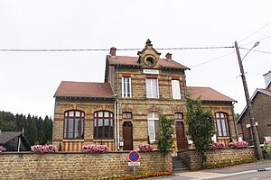
 Town hall (Mairie) of La Chapelle |
||
La Chapelle is a French commune with 178 inhabitants (as of January 1, 2017) in the Ardennes department in the Grand Est region (before 2016 Champagne-Ardenne ). The municipality belongs to the Arrondissement Sedan and the canton Sedan-2 (until 2015 Sedan-Nord ). The inhabitants are called Chapelains .
geography
La Chapelle is about nine kilometers northeast of Sedan on the Belgian border. La Chapelle is surrounded by the neighboring communities Bouillon (Belgium) in the north and northeast, Bazeilles with Villers-Cernay in the east and southeast, Givonne in the south and southwest and Illy in the west and northwest.
The national route 58 runs through the municipality .
Population development
| 1962 | 1968 | 1975 | 1982 | 1990 | 1999 | 2006 | 2012 |
|---|---|---|---|---|---|---|---|
| 125 | 124 | 99 | 116 | 145 | 156 | 164 | 171 |
| Source: Cassini and INSEE | |||||||
Attractions
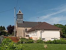
- Saint-Maurice Church
Web links
Commons : La Chapelle - collection of images, videos and audio files

