
Lagos (Portugal)
| Lagos | ||||||
|---|---|---|---|---|---|---|
|
||||||
| Basic data | ||||||
| Region : | Algarve | |||||
| Sub-region : | Algarve | |||||
| District : | Faro | |||||
| Concelho : | Lagos | |||||
| Coordinates : | 37 ° 6 ′ N , 8 ° 41 ′ W | |||||
| Residents: | 3545 (as of June 30, 2011) | |||||
| Surface: | 21.78 km² (as of January 1, 2010) | |||||
| Population density : | 163 inhabitants per km² | |||||
| Lagos county | ||||||
|
||||||
| Residents: | 31,049 (as of June 30, 2011) | |||||
| Surface: | 212.98 km² (as of January 1, 2010) | |||||
| Population density : | 146 inhabitants per km² | |||||
| Number of municipalities : | 4th | |||||
| administration | ||||||
| Administration address: | Câmara Municipal de Lagos Paços do Concelho Séc. XXI Praça do Município 8600-293 Lagos |
|||||
| President of the Câmara Municipal: | Júlio José Monteiro Barroso ( PS ) | |||||
| Website: | www.cm-lagos.pt | |||||


Lagos [ laɡʊʃ ] is a port city on the Portuguese Algarve coast . It is located about 30 km east of Cabo de São Vicente , the most south-westerly point of Europe near Sagres .

history
The Phoenicians and Greeks settled in the bay of Lagos because tuna , sardines and crabs could be caught here. The Carthaginians led in the 4th century BC The cultivation of wine and olives . The Roman name Lacobriga is the first known name of the settlement and is believed to be of Celto-Iberian origin.

Shortly after their landing in Gibraltar (711 AD), the Moors quickly spread across the Algarve. In 716 they conquered Lagos, which they called Zawaia ("fountain" or "lake"). During their rule, the city wall was renewed in the 10th century. In 1189 Dom Sancho I conquered Lagos, but in 1192 the Moors returned. It was not until 1241 that Dom Paio Peres Correia , with military support from German and English knightly orders , was finally able to wrest the city away from the Moors.
In the 15th century, Lagos' port was the starting point for numerous expeditions to Africa that Portugal undertook under Henry the Navigator ( Dom Henrique o Navegador ). On August 21, 1415, under Heinrich's leadership, a fleet of 232 ships set off to conquer Ceuta . The Moorish fortress, opposite Gibraltar on the African side of the strait, was the end point of Sahara caravans and of considerable strategic and economic importance. Heinrich made Lagos an important base for his fleet and had the caravel developed and built here from around 1440 . This new type of ship, based on the model of the Arab dhow, was not only seaworthy and suitable for the coast at the same time, but was also able to sail high upwind and cross against the prevailing wind direction.
From 1433 the navigator Gil Eanes set sail from Lagos several times before finally sailing beyond Cape Bojador for the first time . The cape on the north-west coast of Africa, which today belongs to Western Sahara , was then considered the world's frontier, crossing it as dangerous or even impossible and the coastline of Africa to be covered was largely not yet mapped. The discoverer Gil Eanes, whose biography is largely unclear, is honored today in Lagos as a child of the city and a square in the center, Praça Gil Eanes , bears his name.
Another navigator, Rui de Sequeira , captured a Benin fortress called Eko in present-day Nigeria in 1472 . Today Lagos , the former Eko, is the largest city in Black Africa with 10 million inhabitants and is much better known worldwide than its godmother in Portugal.

The African voyages of Portuguese ships brought black slaves from Guinea and Senegal to Europe for the first time in modern times. Lagos received an important slave market in 1444, the building of which still exists today. It was not until 1820 that human trafficking was banned. The former Nigerian capital Lagos , now the second largest city in Africa , was named after the small Portuguese town. It was the starting port for the slave transports for the slave market in Lagos / Portugal.
In 1476, Christopher Columbus found himself in distress off Lagos during a pirate attack and thus reached Portugal for the first time.
In 1573 Lagos received city rights and in 1577 it became the capital of the Algarve. A year later, in 1578, Dom Sebastião I ( King Sebastian I ) set out with 18,000 soldiers from Lagos to Morocco to take part in the battle of Alcácer-Quibir, which was devastating for Portugal . Sebastião was killed but his body was never found. This fact gave rise to speculation that the king was still alive and the hope that he could turn Portugal's fate again. A modern monument created in 1973 by João Cutileiro commemorates the fate of the "longed-for King Sebastião" on Praça Gil Eanes.
In 1587 the now Spanish-ruled Algarve coast became the area of operations of an English fleet under Francis Drake , whose intention was to prevent an invasion of the British Isles by the Spanish Armada . Drake achieved great success here, but failed in the attempt to take the heavily fortified Lagos.
Due to its strategically important location, the bay of Lagos was also the venue and namesake of sea battles in later times : in a first sea battle near Lagos in 1693, the French fleet under Admiral Tourville sank 80 ships of the Anglo-Dutch fleet, which were under the command of the English admiral Rooke was standing. In a second naval battle near Lagos in the Seven Years' War in 1759 a British naval force defeated a French one.
After the earthquake of 1755, a huge tidal wave eleven meters high devastated the city. Lagos was then rebuilt and the city wall from that time still surrounds large parts of the old town. The Porta do Postigo and the rest of the governor's palace testify to the importance and strength of the port city. However, as a result of the catastrophe, the governor moved to the less destroyed Faro , which replaced Lagos as the capital of the Kingdom of Algarve.
Worth seeing

At Largo Marquês de Pombal is the municipal tourist information. Lagos' well-preserved old town offers visitors not only historical sights, but also cultural facilities, restaurants, cafés and all kinds of shops. Tourists shape the scene in every season and British pubs, discos and a German bakery have set up shop among the local shops.
The historic slave market ( Mercado de Escravos ) was located on the Praça da República (Republic Square; also called Praça do Infante Henrique ). Under the arcades of the Delegação da Alfândega (former building of the customs administration, today exhibition rooms) the black Africans were tied up and offered for sale. A monument to Heinrich the Navigator ( Infante D. Henrique ) has stood on the square since 1960, and was erected on the occasion of the 500th anniversary of his death.
Behind the simple facade of the church Igreja do Santo António is a lavishly furnished, baroque interior. It houses a trompe l'œil ceiling, a gilded Baroque altar, gilded wooden statues, carvings in the choir and azulejos on the walls. Right next to it, the Museu Municipal exhibits sacred art, coins, mosaic fragments and archaeological finds from the Algarve.
Through the city gate Porta de São Gonçalo at the former Castelo dos Governadores (governor's palace) you can reach the Fort Ponta da Bandeira , which has defended the port since the 17th century , over a wooden bridge . From there, the Avenida dos Descobrimentos (Avenue of Discovery) accompanies the Bensafrim river, which is used by fishing boats and yachts as access to the port. Many, sometimes steep, alleys in the historic town center lead down to the palm-lined promenade. Close to the footbridge that leads over the Bensafrim to the port facilities is the beautifully restored fish hall from 1924. On the opposite side of the river, a replica of a historical caravel can be viewed and used for excursions.
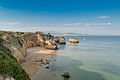
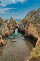
From the marina, newly built in 1995, a service road leads to the 4 km long Meia Praia , the main and sandy beach of Lagos. Other, smaller beaches between rocky cliffs (e.g. Praia Dona Ana, Praia dos Estudantes ) are located on the southern edge of the city, ending with the Ponta da Piedade , a crag with bizarre bays and a spectacular view over the bay of Lagos allowed.
The Lagos Zoo is located a few kilometers outside the city in Barão de São João .

administration
circle
Lagos is the administrative seat of a district of the same name ( concelho ) in the Faro district . On June 30, 2011, the district had 31,049 inhabitants on an area of 213 km².
The neighboring areas are (starting clockwise in the north): Monchique , Portimão , Vila do Bispo and Aljezur .
With the territorial reform in September 2013 , four previous municipalities were merged into two new municipalities, so that the total number of municipalities decreased from six to four.
The following municipalities ( freguesias ) belong to the Lagos district :

| local community | Population (2011) |
Area km² |
Density of population / km² |
LAU code |
|---|---|---|---|---|
| Bensafrim e Barão de São João | 2,425 | 130.20 | 19th | 080707 |
| Lagos (São Sebastião e Santa Maria) | 22,095 | 29.15 | 758 | 080708 |
| Luz | 3,545 | 21.78 | 163 | 080703 |
| Odiáxere | 2,984 | 31.85 | 94 | 080704 |
| Lagos county | 31,049 | 212.98 | 146 | 0807 |
Population development
| 1801 | 1849 | 1900 | 1930 | 1960 | 1981 | 1991 | 2001 | 2011 |
| 9789 | 11,012 | 13,937 | 16,210 | 17,060 | 19,700 | 21,526 | 25,398 | 30,755 |
Municipal holiday
- October 27
Twin cities
_001.jpg)

Town twinning
-
 Spain : Palos de la Frontera (since 1992)
 -
 Portugal : Torres Vedras (since 2009)
 -
 Cape Verde : Ribeira Grande de Santiago (since 2010)
Cooperation agreement
-
 France : Lagos in the Pyrénées-Atlantiques department
-
Spain : Lagos in the municipality of Vélez de Benaudalla , Granada province
-
 Morocco : Boujdour (Portuguese Bojador), Boujdour Province , Western Sahara
-
Cape Verde : São Miguel , Santiago Island
-
 Mozambique : Ilha de Moçambique
-
Mozambique : Pemba
-
 Indonesia : Sikka , Flores Island
-
 South Africa : Ugu , KwaZulu-Natal Province
-
 Senegal : Gorée
-
Portugal : Óbidos
-
Portugal : Guimarães
-
 Greece : Lagos , Didymoticho municipality
-
 Mexico : Lagos , Jalisco State
-
 Brazil : Porto Seguro
traffic
The city's new train station connects Lagos with Faro via the Linha do Algarve .
The bus station, the starting point for city and regional lines, is centrally located on Avenida dos Descobrimentos. Lagos is part of the Rede Expressos national bus network.
Lagos is connected to the A22 motorway, which runs 5 km to the north, via the N120 national road, which has been converted into an expressway . The national road N125 leads 21 km west to Vila do Bispo .


sons and daughters of the town
- Gonçalo de Lagos (1360–1422), beatified Augustinian monk
- Soeiro da Costa (1390–1472), seafarer, one of the twelve knights for England from the 6th song of the Lusiads
- Gil Eanes (15th century), explorer
- Lançarote de Lagos (15th century), explorer
- João Delgado (1553–1612), Jesuit mathematician
- Gaspar Jorge de Leão Pereira († 1576), first Archbishop of Goa
- Henrique Fernandes Sarrão (16th / 17th century), geographer
- Mendonça Pessanha (1775–1856), military, general in defense against the Napoleonic invasions and in the Miguelistenkrieg , conqueror of the rebel Remexido
- José António Ferreira Brak-Lamy (1780–1847), judge and politician, Governor of Alagoas , multiple minister, 1831 Prime Minister
- António José de Lima Leitão (1787–1856), doctor, author, translator, Freemason and liberal politician, reintroduced homeopathy in Portugal
- Onofre Lourenço de Paiva de Andrade (1805–1888), general of the colonial troops in Mozambique and the liberals in the War of Miguelists
- João Bonança (1836–1924), journalist, writer and politician
- José Sebastião Neto (1841–1920), Patriarch of Lisbon
- Joaquim José Machado (1847–1925), military, engineer, politician and colonial administrator
- Alberto da Silveira (1859–1927), military and politician, Minister of the Interior and War Minister
- Henriqueta Júlia de Mira Godinho (1863–1936), wife of President Gomes da Costa
- Adelina da Glória Berger (1865–1922), feminist
- António Júdice Cabral (1868–1956), doctor, researcher and politician
- Júlio Dantas (1876–1962), writer, doctor, politician and poet, important playwright
- Francisco Velhinho Correia (1882–1943), military, politician and university professor, two-time Republican minister
- José Formosinho (1888–1960), archaeologist and notary
- José Lobo da Veiga (1891–1973), pianist and composer
- Arminda Correia (1903–1988), opera singer
- Anatólio Falé (1913–1980), composer and musician
- Frederico Júlio Correia Madeira (1913–1994), doctor
- Nataniel Costa (1924–1995), writer, diplomat and educator
- Jaime Aschemann Bispo Palhinha (1924–2001), archaeologist and educator
- João Carlos de Abreu Pimenta (1926–1999), engineer and author
- Júlia Barroso (1930–1996), actress, singer and educator
- Paulo Galvão (* 1966), composer, musician of old string instruments, guitarist
- Hugo Alves (* 1973), jazz trumpeter and orchestra founder
- Diana Piedade (* 1985), singer
- Diogo Viana (* 1990), football player
See also
literature
- Missler, Eva: Algarve . Ostfildern: Baedeker 2002; ISBN 3-89525-120-8
Web links
- Official website of the city administration
- Portugalvirtual.pt - Tourist Information (English)
Picture gallery
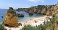
Praia Dona Ana beach
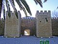
On the wall of Lagos

Lagos seen from the air

In the center of Lagos
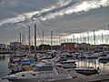
View of the Lagos Marina

Praia do Camilo beach in Lagos
The Praia do Pinhao beach in Lagos
The old town of Lagos
The coast of Lagos
.jpg)


Individual evidence
- ↑ www.ine.pt - indicator resident population by place of residence and sex; Decennial in the database of the Instituto Nacional de Estatística
- ↑ a b Overview of code assignments from Freguesias on epp.eurostat.ec.europa.eu
- ↑ a b www.ine.pt - indicator resident population by place of residence and sex; Decennial in the database of the Instituto Nacional de Estatística
- ↑ Missler: Algarve, p. 106f.
- ^ Publication of the administrative reorganization in the Diário da República gazette of January 28, 2013, accessed on March 16, 2014
- ↑ List of twin cities, website of the city of Lagos (so the addition Ilha de Moçambique in the ANMP list is not applicable), accessed on May 12, 2020.
- ↑ www.anmp.pt , accessed on August 31, 2013

Albufeira | Alcoutim | Aljezur | Castro Marim | Faro | Lagoa | Lagos | Loulé | Monchique | Olhão | Portimão | São Brás de Alportel | Silves | Tavira | Vila do Bispo | Vila Real de Santo Antonio