
List of streets and places in Flensburg / K
| Surname | background | coordinate | sign |
|---|---|---|---|
| * Kaiser-Wilhelm-Strasse | The connecting road to Mürwik was named after Kaiser Wilhelm II , as he had initiated the construction of the Mürwik Naval School . The street was named after the Second World War prompted the Allied Control Council in Murwiker street renamed. See there . |
Location ,Mürwik |
|
| Calf pond | The branches to the west and south of Ebenezer-Howard-Allee were associated with grazing or driving cattle. |
Location ,turnout(zip code 24941) |
|
| Kalkgrund Lime bases
|
According to the location; see. Limestone . A connection to the Kalkgrund lighthouse is not assumed. |
Lage ,Mürwik(ZIP 24944) |
|
| Kanonenberg Kanonbjerget
|
That made the Kanonenberg St.Nikolai's Archers earlier to open the main shooting gun salute with a Böllercannon fire. At the Kanonenberg, next to the rifle house, there was also the shooting range for a long time before it was relocated to the Schützenkuhle . |
Lage ,Friesischer Berg(ZIP 24937) |
|
| Kantstrasse Kantgade
|
Named after the philosopher Immanuel Kant . - With the end of the Second World War , many refugees and displaced persons came to Flensburg . The city grew. Many street names in Flensburg are reminiscent of the old home of immigrants, including this one. |
Lage ,Sandberg(zip code 24943) |
|
| Kanzleistraße Cancelli Gade
|
In a city map from 1779, the road was drawn as a dirt road. There is evidence for the end of the 18th century that a residential building above the Hafermarkt , at the beginning of today's Kanzleistraße, was called "Chancellery". An employee of the chancellery of Glücksburg Castle is said to have had his residence in the house, which is apparently no longer preserved . The existing buildings at the beginning of the street were not built until 1830. |
Lage ,Sandberg(zip code 24943) |
,_Bild_001.JPG)
|
| * Captain's path | See Shipping Museum Flensburg # Kapitänsweg |
Location ,Flensburg city center / Jürgensby / Friesischer Berg(zip code) |

|
| Kappelner Strasse Kappelgade
|
Old road to Kappeln . |
Lage ,Sandberg(zip code 24943) |

|
| Karlstrasse Karlsgade
|
Named after Carl von Prussia . |
Lage ,Jürgensby(ZIP 24937) |
|
| * Kastanienallee Ringstrasse | See under Millennium Avenue |
Location ,Tarup |
.JPG)
|
| Kastanienweg Kastanievej
|
There used to be chestnut trees there . |
Lage ,Friesischer Berg(ZIP 24937) |
|
| Kate-Lassen Way Kate Lassens Vej
|
Named after the painter Käte Lassen . |
Lage ,Jürgensby(ZIP 24943) |
|
| Käte-Petersen-Weg | Käte Petersen (1907–1988) was a Flensburg librarian who ran the library in Flensburg's Neustadt from 1930 to 1936. She then worked as the library center of the German Border Association for the rural library system. In 1939 she became the head librarian at the library headquarters in the province of Schleswig-Holstein (see Schleswig-Holstein library headquarters ). In 1970 she was awarded the Order of Merit of the Federal Republic of Germany for her 40 years of work on the book. The neighboring streets of Kauslund were named like these dedicated women. |
Lage ,Engelsby(ZIP 24943) |
|
| Käte-Wolff-Weg | The path from the Garden City to the Schäferhaus Foundation Land , where a few remains of the Jägerslust farm are located, was named in 2010 after Käte Wolff, who used to live there but was abducted and murdered during the Nazi tyranny. |
Location ,turnout(zip code 24941) |
|
| * Katharinenhof Katharinegården
|
Abbreviated name of the street Am Katharinenhof . Located at Katharinenhof (Harrislee) . |
Lage ,Nordstadt(zip code 24939) |
|
| Katharinenstrasse Katrinegade
|
The farmer Georg Jensen (* 1849, † 1909) married the daughter of an innkeeper from Friesische Strasse named Catharina Jordt in 1874 . Jensen bought land in the area around the same time. Jensen also ran a dairy farm on Friesische Strasse . His wife probably supported him in the business. He and his wife had three sons. Georg Jensen named his property after his wife: "Catharinenruh". The street name was probably derived accordingly. |
Lage ,Friesischer Berg(ZIP 24937) |
|
| * Katsund (also: Kattsund ) |
See Katsund |
Location ,Flensburg city center |
|
| Kauslunder Straße (also: Kauslunderstraße ) Kauslundsgade
|
See Kauslund . |
Lage ,Engelsby(ZIP 24943) |

|
| Kauslunder angle | See Kauslund . |
Lage ,Engelsby(ZIP 24943) |
|
| Kauslundhof | See Kauslund . |
Lage ,Engelsby(ZIP 24943) |
|
| Causal gap | Gap means paddock , or more generally defined: "fenced in parcel". See for more: Kauslund . |
Lage ,Engelsby(ZIP 24943) |
|
| Keesgang Ostegang
|
There was a cheese dairy there in the 1910s . |
Lage ,Sandberg(ZIP 24937) |
,_Bild_003.JPG)
|
| Keitumer way Kejtumvej
|
Named after the Sylt town of Keitum . In addition to the Keitumer way which is Sylt street . |
Location ,turnout(zip code 24941) |
|
| Kelmhof Kelms Gård
|
Hof, which was named in honor of the architect Adalbert Kelm , who built the nearby “Red Castle” of the Mürwik Naval School . |
Lage ,Mürwik(ZIP 24944) |

|
| Kelmstrasse Kelsmgade
|
Access road to the “Red Castle” of the Mürwik Naval School , which was named in honor of the architect Adalbert Kelm . She got her name on “11. 11. 1911 ”, one year after the inauguration of the naval school. Later on, residential buildings for members of the Navy were built on Kelmstrasse . From 1912 to 1957, the terminus of tram line 3 was directly below Kelmstrasse . There is still a bus stop in the area today. Today, private individuals can drive on Kelmstrasse to the gate guard of the Mürwik Naval School . |
Lage ,Mürwik(ZIP 24944) |

|
| Keplerweg Keplervej
|
Named after the natural philosopher, mathematician, astronomer, astrologer, optician and Protestant theologian Johannes Kepler . |
Lage ,Fruerlund(zip code 24943) |
|
| Lapwing ring | Street that is being built in the new development area of Tarup . Named after the lapwing bird species . |
Lage ,Tarup(ZIP 24943) |
|
| Pine yard Fyrregården
|
Located by the pine path. Named after the pine coniferous plant . The neighboring dead ends were named similarly. Opposite the Kiefernhof there is an old farm (see Friedheim (Flensburg) ). |
Lage ,Mürwik(ZIP 24944) |
.jpg)
|
| Pine path Fyrrevej
|
Named after the pine coniferous plant . The neighboring streets were named similarly. The street was given its name on January 20, 1953. In a map from 1904, however, its course is evidently already marked. The Kiefernweg apparently originally served as a connecting road between Twedter Holz and Wasserloos . The southern area of the road connection was named Wasserlooser Weg . |
Lage ,Mürwik(ZIP 24944) |
,_Bild_001.JPG)
|
| * Kiel facilities | The so-called Kiel train station used to be located there ; see. Flensburg circular railway . Today there is a parking lot there. |
Lage ,Jürgensby(ZIP 24937) |
|
| Kielseng Kilseng
|
See Kielseng . |
Lage ,Fruerlund(zip code 24937) |
,_Bild_02.JPG) - -
|
| Gravel path Grusvejen
|
See gravel |
Lage ,Tarup(ZIP 24943) |
|
| Kirchenallee Kirkeallé
|
The street leading to the Heilandskapelle got its name in 1955. |
Location ,turnout(zip code 24941) |
|
| Kirchensteig Kirkesti
|
The cul-de-sac was officially named in 1972. Directly to the east of the cul-de-sac is a footpath that continues eastwards. The " Steig " leads towards Adelby Church . |
Lage ,Sandberg(zip code 24943) |
|
| Kirchentoft Kirketoften
|
The name means "Kirchenfeld". Apparently the oldest area of Engelsby-Süd (see there for more). |
Lage ,Engelsby(ZIP 24943) |
|
| * Church Square | Place in front of the Christ Church in Mürwik |
Location ,Mürwik |
|
| Klabundeweg Klabundevej
|
Named after the journalist and politician Erich Klabunde who promoted social housing in post-war Germany . The self-help building association has its headquarters in the quarter . |
Lage ,Fruerlund(zip code 24943) |
|
| Klaus-Groth-Strasse Klaus Groths Gade
|
Named after the Low German poet and writer Klaus Groth . The neighboring Hebbelstrasse was originally part of Klaus-Groth-Strasse. Compare there |
Lage ,Friesischer Berg(ZIP 24937) |
.jpg)
|
| * Small exe Lille Exegade
|
The street is on the exe . Although it is entered on many cards as part of the exe , it is obviously not part of the address. The market watch located there is only used during events and therefore has no address. There is no street sign. |
Lage ,Friesischer Berg(ZIP 24937) |
|
| Small paddock Lille Kobbel
|
The street name suggests that there was a small paddock there. This was obviously in the area of the former Stadtfeld of the city of Flensburg . |
Lage ,Mürwik(ZIP 24944) |
|
| Small gap Lille Løkke
|
Gap means paddock , or more generally defined: "fenced in parcel". |
Lage ,Mürwik(ZIP 24944) |
.jpg)
|
| Little fox farm | Named after the butterfly Kleiner Fuchs . |
Location ,turnout(zip code 24941) |
|
| Kleine Sophienstrasse Lille Sophiegade
|
In 1882 Sophienstrasse was named after Princess Sophie of Prussia (1870-1932). In 1898 the neighboring Kleine Sophienstrasse was named. The street should not be confused with the Sophienhof in Flensburg , which is in a different part of the city. |
Lage ,Friesischer Berg(ZIP 24937) |
|
| Small St. Jürgen staircase Lille Skt. Jørgens bustard
|
The stairway was named after St. Jürgen . The (Great) St. Jürgen's Staircase is also not far away . The small St. Jürgen staircase overcomes a height difference of 63 meters. Like the (large) St. Jürgen staircase, it connects the captain's quarter (of the St. Jürgen district ) with the Jürgensgaard district . |
Lage ,Jürgensby(ZIP 24943) |

|
| * Little Trögelsby | The sidewalk has been reminiscent of Klein Trögelsby since July 5, 1979 . The sidewalk does not currently have a street sign, but is shown on some street maps. See for more: Trögelsby |
Location ,Engelsby |
|
| Cloister walk Convent walks
|
Walk at the Franciscan monastery in Flensburg . |
Location ,Flensburg city center(zip code 24937) |
,_Bild_001.JPG)
|
| * Monastery wood Klosterskov
|
Crossing area of Mürwiker Strasse with Blücherstrasse and Swinemünder Strasse ; See monastery wood |
Location ,Mürwik |
|
| Klosterholzweg Klosterskovvej
|
See Klosterholz |
Lage ,Mürwik(ZIP 24944) |
|
| Klueser way Kluesvej (actually: Klus in Danish)
|
See Klues . |
Lage ,Nordstadt(zip code 24939) |
|
| Klueser Winkel Klueskrogen
|
See Klues . |
Lage ,Nordstadt(zip code 24939) |
|
| Kluesrieser way Kluesrisvej
|
Leads to the Kluesries . The path used to be called " Niehuuser Weg ". It was renamed in the late 1980s and has had the new, appropriate name ever since. |
Lage ,Nordstadt(zip code 24939) |
|
| Knappenstrasse Væbnergade
|
Street name with reference to Duburg . |
Lage ,Neustadt(zip code 24939) |
|
| Knud-Laward-Strasse | Named after Knud Lavard . Located directly behind the Knudsgildehof; see. Knudsgilde (Flensburg) . |
Location ,Flensburg city center(zip code 24937) |

|
| Knuthstrasse Knuthsgade
|
In Knuthstrasse there is a memorial sign with the wording: "Knuthstrasse, Markus Knuth 1811-1899, businessman and city councilor". |
Location ,Westliche Höhe / Neustadt(zip code 24939) |
,_Bild_001.JPG)
|
| Kockeschünegang Kocks loading gear
|
"Schüne" is Low German for barn. The corridor was apparently the way to Kock's barn. The barn no longer exists today. Today the Lütte Mühlenteich lies at the Kockschünegang . - The forest path, which is also little known in Flensburg , usually does not attract any particular public attention. In June 2017, a navigation system led a non-local truck driver with his 40-ton truck onto the small farm road . The alerted police officers found the truck stuck in the bushes. The city's Technical Operations Center (TBZ) then shortened the plants there. A Handewitter tow company finally freed the truck so that it could continue its journey. |
Lage ,Südstadt(zip code 24941) |
|
| Kohlweißlingsweg | Named after the cabbage white butterfly , the butterfly species of the large cabbage white butterfly and the small cabbage white butterfly . |
Location ,turnout(zip code 24941) |
|
| * Kollundt's walk | The street name, also spelled “Kollundtsgang”, has apparently been handed down since the beginning of the 19th century. The corridor was named after the Lorenzen Collundts family of boatmen and shipowners, who also gave the Collundtspark its name . The Kollundts Gang is located at Margarethenhof . After a renovation and redesign of the area there, the Kollundts Gang was apparently officially added to the Am Margarethenhof . Nowadays the street is obviously no longer assigned a house number. |
Location ,Juergensby |
|
| Colonist Way | South of the city limits to Weding and Jarplund , between Husumer Straße to the west and Eckernförde Landstraße to the east , there were at least eight colonist houses in the 18th century . The colonists (see potato Germans ) should cultivate the wasteland there . One of these colonist houses was between the boundary stone 22 and the boundary stone 23 and was named "Friedrichshof". A small courtyard with this name ( coordinate of the courtyard ) is still located on the site of the former colinist house . The Kolonistenweg got its name in 1998. |
Location ,turnout(zip code 24941) |
|
| Company course | Leads to Kompagniestraße, at the end of which is the Kompagnietor . |
Location ,Flensburg city center(zip code 24937) |
|
| Kompagniestrasse Kompagnigade
|
The Kompagnietor is at the end of the street leading to the harbor . |
Location ,Flensburg city center(zip code 24937) |
|
| Koenigstrasse Kongegade
|
Street name with reference to Duburg . |
Lage ,Neustadt(zip code 24939) |
,_Bild_001.JPG)
|
| Kong Arrildshoj Park | "King Arrild's Park"; See Kong Arrilds Høj |
Location ,turnout(zip code 24941) |
|
| Convent garden Conventhaven
|
The foreign word "convention" comes from Latin and means "gathering" or "assembly". The convent garden was an inn that opened in 1866. The Konventgarten inn has not existed for a long time. In addition to the street, the small park with a playground is also called the convent garden these days. |
Lage ,Sandberg(ZIP 24937) |

|
| * KptLt Dirk Brüne Strasse | The street is on the Flensburg-Mürwik base , by the parking lot of the naval school . It extends from Kelmstrasse to Twedter Mark (cf. Twedter Mark ). It is over 350 meters long. Captain Dirk Brüne is or has been responsible for the school's infrastructure since 1995. In this context, he also coordinated the extensive construction and renovation work for the castle's 100th birthday in 2010. The street name has been listed in OpenStreetMap since at least 2014 . |
Location ,Mürwik |
|
| County road | In Flensburg there are various road connections that serve as district roads . See list of district roads in Flensburg . - The most famous one is probably Kreisstraße 8 at the moment. | Different locations | |
| District road 8 | District road 8 (K 8) is apparently intended to serve as a Tarup bypass road , as an access road for residential areas near Tarup , as a feeder road to the east bypass and as an access road to Flensburg city center . Kreisstraße 8 consists of the following individual streets: Bahnhofsstraße (near the city center ), Munketoft (near campus) and Hochfelder Landstraße (near Hochfeld ) as well as the Tastruper Weg extended to Taruper Hauptstraße . The first two streets had been completed for decades. The Hochfelder Landstrasse has been built since 2009. The last of the four construction sections of the street (the extension to Taruper Hauptstraße) should take place around 2018. A road connection to Tarup could be completed by 2017, but the last section, which was planned in a curved course, could only be realized with a delay. The city failed to acquire the property. The town hall planners therefore applied for the property owner to be expropriated. On May 21, 2019, said last stretch of road was opened to traffic. |
Location ,Südstadt / Sandberg / Tarup |
|
| Cross coupling Korskobbel
|
The street name indicates a " paddock at Tarup Kreuz ". |
Lage ,Tarup(ZIP 24943) |
|
| Cross gap Korsløkken
|
Gap means paddock , or more generally defined: "fenced in parcel". The word “gap” should also have meant a paddock . The name Kreuzlücke probably originally referred to a paddock at Tarup Kreuz . |
Lage ,Tarup(ZIP 24943) |
|
| Kruger Street | Named after the patriot and soldier in the wars of liberation Friederike Krüger . |
Lage ,Fruerlund(zip code 24943) |
|
| Short street Korte Gade
|
The road is short . |
Lage ,Jürgensby(ZIP 24937) |
|
| Sexton loophole | It is a historical field name. Gap means paddock , or more generally defined: "fenced in parcel". Not far from the Küsterlücke is, clearly visible, the Adelbyer Johanniskirche , from the 12th century. Next to the pastorate of the church there is also a sexton's apartment and the former sexton's school from 1650, today the parish hall. In the middle of the 19th century, the Küsterschule was the largest rural school in the provost's office in Flensburg . The street name therefore means "Küsterkoppel". The road was built around 2006-2009 as a junction from Adelbyer Kirchenweg in order to develop the new building area there. |
Lage ,Sandberg(zip code 24943) |
- Footnotes
- ↑ Flensburger Tageblatt : Special publication: 100 Years Ago: Four Villages for the City , from: April 1, 2010; Retrieved on: March 2, 2015
- ↑ Flensburger Tageblatt : View of the annual rings of the growing city , August 11, 2012; Retrieved on: February 26, 2015
- ↑ Flensburger Tageblatt : 100 years of incorporation: The gray donkey and the emperor's piste , from: May 6, 2010; Retrieved on: March 4, 2015
- ↑ Flensburg street names . Society for Flensburg City History, Flensburg 2005, ISBN 3-925856-50-1 , article: Kanzleistraße
- ^ Lutz Wilde: Monument topography Federal Republic of Germany, cultural monuments in Schleswig-Holstein. Volume 2, Flensburg, p. 564 ff.
- ^ Writings of the Society for Flensburg City History (ed.): Flensburg in history and present . Flensburg 1972, page 441
- ↑ Designation of streets in the residential area “Kauslund-Osterfeld” (development plan no. 232) ( Memento from April 7, 2018 in the Internet Archive ), p
- ↑ Flensburger Tageblatt : The tragic end of "Jägerslust" , from: September 29, 2010; accessed on: October 24, 2019
- ^ Writings of the Society for Flensburg City History (ed.): Flensburg in history and present . Flensburg 1972, page 442
- ^ Map of Flensburg North 1904 ( memento from February 29, 2012 in the Internet Archive ), accessed on: May 10, 2015
- ↑ Kieler Anlagen car park ; Retrieved on: February 20, 2015
- ↑ Flensburger Tageblatt : Above the roofs of Flensburg: Over 145 steps to the super view , from: August 30, 2017; accessed on: November 12, 2019
- ↑ Gerret Liebing Schlaber: From the country to the district. Flensburg's Stadtfeld and the incorporated villages in pictures and words approx. 1860-1930. Flensburg 2009. page 125
- ^ The Duburg, fortress and castle on the western height ( Memento from June 21, 2015 in the Internet Archive ), pages 7 and 10
- ↑ Flensburger Tageblatt : Schleichwege: Where the southern part of the city is greenest , from: May 6, 2014; Retrieved on: March 2, 2015
- ↑ Flensburger Tageblatt : Flensburg: Navi sends 40-ton trucks on forest path , from: June 27, 2017; Retrieved on: June 28, 2017
- ↑ Street directory with district division of the arbitrators , from: June 2011; accessed on: November 7, 2019
- ^ Dieter Pust: Flensburg street names . Society for Flensburg City History, Flensburg 2005, ISBN, article: Kollundts Gang
- ↑ See OpenStreetMap-Wiki. Flensburg-stat , from: January 21, 2018; accessed on: November 7, 2019
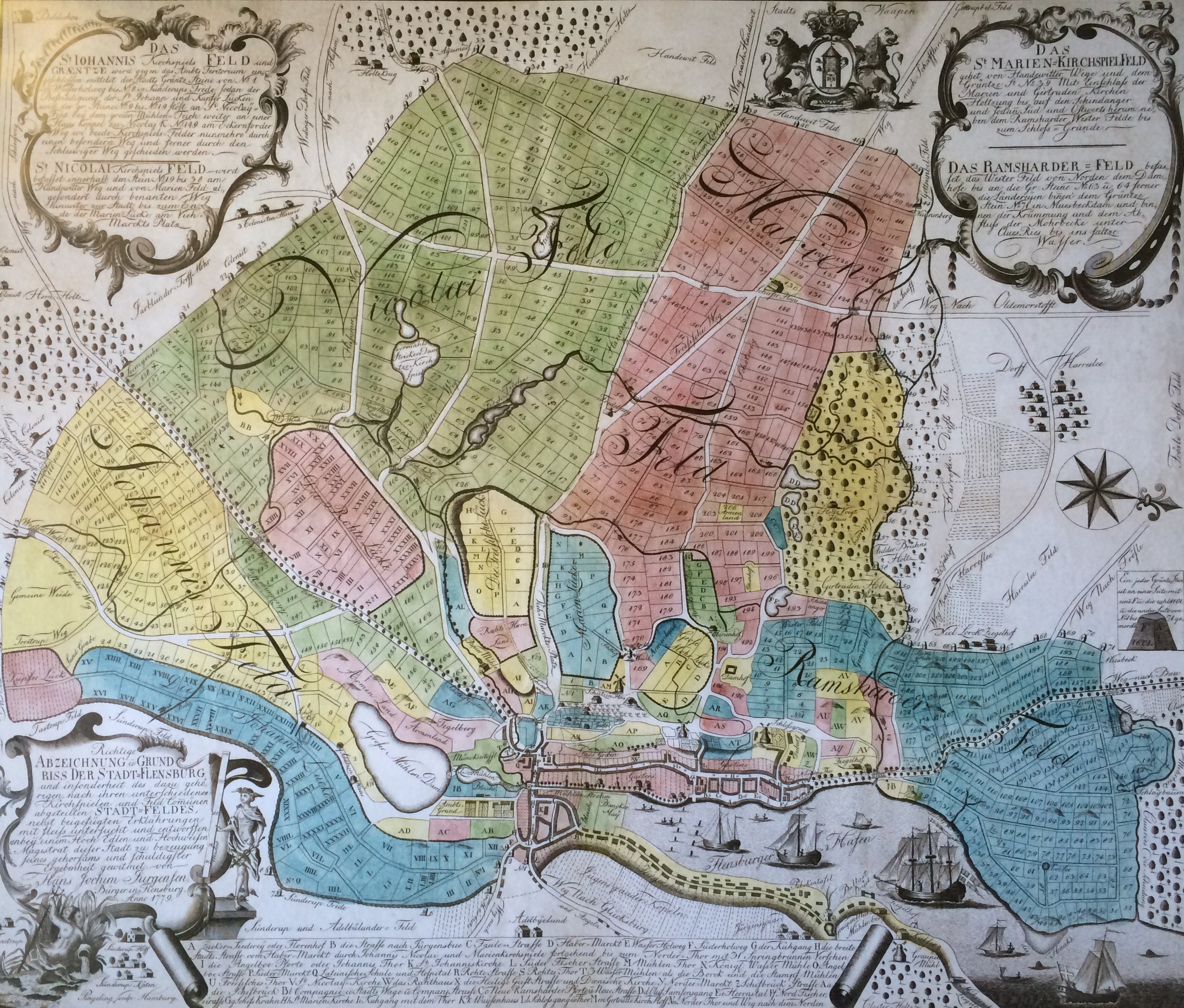
- ^ Map of Flensburg and the surrounding area, 1779
- ↑ Flensburger Stadtgeschichte eV (ed.): Learn history. A discovery tour along Flensburg's old boundary stones , from December 1, 2012; The GPS coordinates of the poster are obviously incorrect or do not correspond to the general standard. The boundary stones cannot be determined using the coordinates given there.
- ^ The Duburg, fortress and castle on the western height ( Memento from June 21, 2015 in the Internet Archive ), pages 7 and 10
- ↑ Online Duden. Entry: Convention , accessed on: November 24, 2019
- ↑ IHR redevelopment agency (ed.): Urban renewal in Flensburg, Eastern Old Town and Achter de Mühl redevelopment areas 1988 to 2009, page 79
- ^ Streets in Germany. KptLt Dirk Brüne Straße in Flensburg , accessed on: October 24, 2019
- ↑ KptLt Dirk Brüne road , retrieved on: June 14, 2015; or with a map of their overall course there ( Memento from March 4, 2016 in the Internet Archive )
- ↑ Flensburger Tageblatt : Trampedachlager: Five of seven barracks are being demolished , from: May 9, 2009; accessed on: June 14, 2015
- ↑ The K8 conquers new territory - extension of Kreisstraße 8 to the east ( memento from November 29, 2014 in the Internet Archive ), accessed on: March 5, 2015
- ↑ WiF, county road 8 ( Memento of 24 December 2014 Internet Archive ), accessed on: 5 March 2015
- ↑ Flensburger Tageblatt : Another three years until the Tarup-Tangente , from: September 15, 2009; Retrieved on: March 5, 2015
- ↑ Flensburger Tageblatt : Plan B is missing for B-Plan 272 , dated: February 24, 2017
- ↑ Flensburg: K8 opened to traffic on time , accessed on: May 20, 2019
- ^ Dieter Pust: Flensburg street names . Society for Flensburg City History, Flensburg 2005, ISBN, article: Kreuzkoppel
- ↑ Cf. Flensburger Tageblatt : 725 years of Flensburg: Tarup - the small village with the crucifix , from: Aug. 27, 2009; Retrieved on: March 5, 2015
- ↑ Cf. Flensburger Tageblatt : 725 years of Flensburg: Tarup - the small village with the crucifix , from: Aug. 27, 2009; Retrieved on: March 5, 2015
- ^ RV-110/2006, street names , dated: September 6, 2006; accessed on: November 14, 2019
- ↑ WiF, Sexton gap ( Memento of 21 February 2015, Internet Archive ); Retrieved on: March 2, 2015
- ↑ Flensburger Tageblatt : Großadelbylund : Construction freeze: Chaos at the Küsterlücke , from: November 2, 2009; Retrieved on: March 2, 2015
- ↑ Flensburger Tageblatt : Küsterlücke: With Timmy in the third construction phase , from: June 24, 2011; Retrieved on: March 2, 2015