Milhostov
| Milhostov | ||||
|---|---|---|---|---|
|
||||
| Basic data | ||||
| State : |
|
|||
| Region : | Karlovarský kraj | |||
| District : | Cheb | |||
| Area : | 1762.7784 ha | |||
| Geographic location : | 50 ° 9 ' N , 12 ° 27' E | |||
| Height: | 441 m nm | |||
| Residents : | 328 (Jan 1, 2019) | |||
| Postal code : | 350 02 | |||
| License plate : | K (old CH) | |||
| structure | ||||
| Status: | local community | |||
| Districts: | 3 | |||
| administration | ||||
| Mayor : | Pavel Červenický (as of 2018) | |||
| Address: | Milhostov 68 350 02 Cheb 2 |
|||
| Municipality number: | 554651 | |||
| Website : | www.milhostov.cz | |||
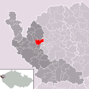
| Location of Milhostov in the Cheb district | ||||

|
||||
Milhostov ( German Mühlessen ) is a municipality in Karlovarský kraj in the Czech Republic .
geography
Geographical location
Milhostov is located about 11 km northeast of Cheb in the Okres Cheb of the same name . The Plesná ( Fleißenbach ) flows through the locality .
Community structure
The community Milhostov consists of the districts Hluboká ( nuns green ), Milhostov ( mills ) and Vackovec ( Watzgenreuth ). Basic settlement units are Děvín ( Döba ), Dolní Částkov ( Unter Schossenreuth ), Doubrava ( Doberau ), Hluboká, Milhostov and Vackovec.
The municipality is divided into the cadastral districts of Děvín, Dolní Částkov, Doubrava u Milhostova, Hluboká u Milhostova, Milhostov and Vackovec.
history
The place name is - like many in the area - probably of West Slavic origin. Mühlessen was an old noble seat and in 1219 belonged to Poppo von Milosz, who paid interest to the city council of Eger. The first written mention of the place Milocz comes from the year 1219, when in a document of King Friedrich II for the Waldsassen monastery a Poppo von Milhozt is mentioned.
The old church consecrated to St. Nicholas can be traced back to 1300 ; 1306 it is mentioned as a branch of Frauenreuth. 1322 Mylosen is on the list of places of the pledged Egerland . During the reign of Charles IV , the property was distributed over 24 farms and made subordinate to the city of Eger (until the end of the manors in 1848). In 1429 the Hussites burned the village down. During the Reformation , when the whole of the Egerland was Evangelical-Lutheran, the first village school was built. Ecclesiastically Mühlessen belonged to the parish of Frauenreuth until 1722 , then to Nebanitz . In Mühlessen No. 28, a farm the size of 100 hectares, Johann Georg Sölch (1832–1873), the father of the writer Irmgard Höfer von Feldsturm, was born.
Mühlessen had been its own parish since 1905. From the middle of the 19th century, the place belonged to the judicial district Wildstein and district Eger in the Austro-Hungarian monarchy . After the end of the First World War in 1919, the place fell to the new Czechoslovakia , from 1938 to 1945 it was part of the Sudetengau of the German Empire. Around 1940, a section of a Reichsautobahntrasse was built between Watzgenreuth and Trebendorf , which remained unfinished and whose dam is still clearly visible in the area of the Fleißenbachtal .
In the spring of 1945, at the end of the Second World War, American troops occupied the village, but withdrew in accordance with the treaty in October 1945; the Czechoslovak authorities returned. In the course of the expulsion of the Germans from Czechoslovakia , the exclusively German population of Mühlessen was forced to leave the place and made room for new settlers.
Population development
|
|
|
Culture and sights
- Parish Church of St. St. Nicholas from the early 13th century with Romanesque and Gothic components, which was rebuilt and expanded in the Baroque style in the second half of the 17th century and renovated in 1919. The high altar dates from around 1760. The church stands in the middle of the walled cemetery on a hill.
- Marian column with a rose capital and a double-sided stone sculpture of the Mother of God sitting on a crescent moon with the baby Jesus on the arm. She looks to the east and west as a double figure; Donated in 1706 by the owner of the mill house No. 13, J. Werner, and was built on the town square.
literature
- Eger homeland. History of a German landscape in documentaries and memories. Egerer Landtag eV Amberg in the Upper Palatinate, 1981; there: Mühlessen, dialect M (ü) lassn, CSR and CSSR Milhostov, pages 395 to 397 with a map, the house owners of Mühlessen and Stobitzhof from 1945 and a picture of the church of St. Nicholas.
- Lorenz Schreiner : Monuments in the Egerland. Documentation of a German cultural landscape between Bavaria and Bohemia. With the participation of the State Archives in Cheb under J. Bohac and other collaborators. Egerer Landtag eV home association for Eger city and country, 2004, Amberg in the Upper Palatinate, there: Mühlessen / Milhostov, before 1945 municipality with the districts Mühlessen, Stopitzhof and Föhlamühle, pages 684 to 687, with an illustration, u. a. a photo of the Marian column with the double-sided Mother of God on a crescent moon.
Web links
Individual evidence
- ↑ http://www.uir.cz/obec/554651/Milhostov
- ↑ Český statistický úřad - The population of the Czech municipalities as of January 1, 2019 (PDF; 7.4 MiB)
- ↑ http://www.uir.cz/casti-obce-obec/554651/Obec-Milhostov
- ↑ http://www.uir.cz/zsj-obec/554651/Obec-Milhostov
- ↑ http://www.uir.cz/katastralni-uzemi-obec/554651/Obec-Milhostov
- ↑ see: German Gender Book, Volume 214, 2002, CAStarke Verlag Limburg an der Lahn, Sölch family from Zettendorf, Eger district in Böhmen, pages 1020 and 1021
- ↑ Historický lexikon obcí České republiky - 1869-2015. Český statistický úřad, December 18, 2015, accessed on February 10, 2016 (Czech).


