
Manowo
| Manowo | |||
|---|---|---|---|

|
|
||
| Basic data | |||
| State : | Poland | ||
| Voivodeship : | West Pomerania | ||
| Powiat : | Koszalin | ||
| Gmina : | Manowo | ||
| Geographic location : | 54 ° 7 ′ N , 16 ° 18 ′ E | ||
| Residents : | 760 | ||
| Postal code : | 76-015 | ||
| Telephone code : | (+48) 94 | ||
| License plate : | ZKO | ||
| Economy and Transport | |||
| Street : | DK 11 : Kołobrzeg ↔ Bytom | ||
| Rail route : | no rail connection | ||
| Next international airport : | Szczecin-Goleniów | ||
| Gmina | |||
| Gminatype: | Rural community | ||
| Gmina structure: | 23 localities | ||
| 9 school offices | |||
| Surface: | 118.57 km² | ||
| Residents: | 6909 (Jun. 30, 2019) |
||
| Population density : | 58 inhabitants / km² | ||
| Community number ( GUS ): | 3209042 | ||
| administration | |||
| Community leader : | Roman Kłosowski | ||
| Address: | Manowo 40 76-015 Manowo |
||
| Website : | www.manowo.pl | ||

Manowo ( German Manow ) is a village with a rural community (Gmina wiejska) in the Polish West Pomeranian Voivodeship and belongs to the Powiat Koszaliński ( Köslin district ).
Geographical location
The village is located in Western Pomerania , nine kilometers southeast of the city of Köslin ( Koszalin ).
The Polish state road 11 (formerly German Reichsstraße 160 ) leads to the place, which leads from Kolberg ( Kołobrzeg ) on the Baltic Sea to the Upper Silesian Bytom ( Bytom ) and will be expanded as the S 11 expressway in the next few years . In place an eleven kilometer long side road branches off, which connects the place with the voivodship road 167 , which runs from Köslin via Tychowo ( Groß Tychow ) to Ogartowo ( Jagertow ) near Bad Polzin ( Połczyn-Zdrój ). The place does not have its own train station; the next is in Köslin on the State Railways No. 202 Stargard - Danzig and 402 Goleniów ( Gollnow ) - Kołobrzeg - Koszalin.
Through the village flows Manowsche Bach , who in the eight- or Hintersee pours.
Manowo Village ( Manow )
history


Manow was in Glasenappsche's fief until the 19th century and was named as such in the second half of the 14th century. By contract of July 23, 1637 the goods went to the District Administrator a. D. Carl Alexander Wilhelm Graf von Wartensleben , who sold them ten years later to the Holtz brothers from Western Pomerania . Georg Holtz owned the goods Bonin (today in Polish: Bonin), Manow (Manowo), Roßnow (Rosnowo) and Seidel (Wyszewo). In 1806 the estates became vacant.
Until 1945 Manow belonged to district Koszalin in the administrative district of Koszalin the Prussian province of Pomerania . Manow formed a separate administrative district with the communities of Mersin (now in Polish: Mierzym), Roßnow, Seidel and Zewelin (Cewlino). In addition, the place was the seat of the registry office for the communities Manow, Bonin, Roßnow, Seidel and Zewelin.
In 1910 there were 247 residents registered in Manow. Their number rose to 332 by 1933 and was 336 in 1939.
Towards the end of the Second World War, the Red Army occupied the region in the spring of 1945 . Soon afterwards Manow was placed under Polish administration together with the whole of Western Pomerania . Manow received the Polish place name Manowo . The Alteinwohner of Manow were in the period that followed sold .
Since 1945 the place now called Manowo belongs to the powiat Koszaliński in the Polish West Pomeranian Voivodeship (until 1998 Koszalin Voivodeship ). 760 people live here today. Manowo is part and headquarters of Gmina Manowo.
church
Parish
Before 1945 the population of Manow was predominantly of Protestant denomination. The village parish seat was the same parish at which the branch communities Bonin (today Polish also: Bonin) and Seidel (Wyszewo) and the location Zewelin (Cewlino) belonged. The parish was incorporated into the church district of Köslin in the eastern district of the church province of Pomerania of the Church of the Old Prussian Union .
In 1940 the entire parish had 1701 parishioners, 766 of whom belonged to the Manow area. The church patronage in Manow and Seidel was the responsibility of Prince von Hohenzollern-Sigmaringen , and to a small extent also the settlers in Manow.
In 1707 the church and rectory burned down in Manow, but were rebuilt by the then landowner, Rittmeister Peter von Glasenapp . During the Second World War , the Manow church registers were saved and are now in the State Archives (Archiwum Państwowe) in Koszalin .
Since 1945 the population of Manowo has been almost without exception Catholic denomination. It has had its own parish here since 1992 (a vicariate since 1990), to which 1434 parishioners belong today. The parish is in the area of the dean's office Bobolice ( Bublitz ) in the diocese of Köslin-Kolberg of the Catholic Church in Poland . The church is now called Kościół Matki Bożej Wspomożenia Wiernych and was consecrated on May 23, 1983.
Protestant church members living here are integrated into the parish Koszalin in the diocese of Pomerania-Greater Poland of the Evangelical-Augsburg Church in Poland .
Pastor
Up to 1945 there were 17 Protestant clergymen in Manow, and since 1990 five Catholic clergy:
- Paulus Krüger, 1552–1575
- Andreas Pannekoke, 1575-?
- Heinrich Broier
- Friedrich Culichius (Zülich), until 1684
- Michael Wisch, 1684-?
- Johann Christian Koch, until 1749
- Melchio Moritz Mützell, 1749–1765
- Karl Friedrich Müller, 1765–1773
- Martin Ludwig Wilhelm Grützmacher, 1773–1786
- Hermann Friedrich Mützell (son of 8th), 1786–1819
- Johann August Ludwig Beitzke, 1819–1827
- Friedrich Carl Otto Franz Richter, 1828–1857
- Karl Ludwig Friedrich Cremer, 1857–1860
- Eugen August Friedrich Heinrich Kumme, 1860–1874
- Robert Ludwig Tobis Enghardt, 1875–1895
- Karl Degner, 1895–1928
- Friedrich Kübler, 1928–1940 (?)
- Andrzej Bujar, 1990-1994
- Jan Domin, 1994-2002
- Andrzej Żołyniak, 2002–2006
- Andrzej Hryckowian, 2006-2007
- Leszek Szurek, since 2007
Gmina Manowo
General

The rural municipality of Manowo covers an area of 188.57 km², which corresponds to 11.3% of the total area of the Powiat Koszaliński . With a population of 6,292 the municipality ranks 59th out of 114 municipalities in the West Pomeranian Voivodeship .
The Gmina Manowo borders in the northeast on the nature reserve of Jezioro Lubiatowskie ( Lüptow See ), which is already in the urban area of Koszalin. In the south of the municipality flows the Radew ( Radüe ), which runs through the Jezioro Rosnowskie ( Roßnow See ).
There are three postcode areas in the municipality :
- Bonin ( Bonin ) = 76-009
- Manowo ( Manow ) = 76-015
- Rosnowo ( Roßnow ) = 76-042.
Neighboring communities of Gmina Manowo are:
- the city of Koszalin ( Köslin ) and the municipalities:
- Bobolice ( Bublitz ), Polanów ( Pollnow ), Sianów ( Zanow ) and Świeszyno .
Community structure
Gmina Manowo includes a total of 23 localities, which are assigned to nine districts (" Schulzenämtern "):
- Districts :
|
- Other localities : Dęborogi ( Hoheneichen ), Gajewo ( Grünhaus ), Grąpa ( Grumpe ), Grzybniczka ( Neu Griebnitz ), Jagielno, Kliszno ( Klieschen ), Kopanica ( Gipp ), Kopanino ( Koppelsberg ), Kostrzewa ( Wilhelmsthal ), Lisowo ( Feldkaten ) , Mostowo ( Brückenkrug ), Policko ( Eckerndaus ), Poniki ( Ponicken ), Wiewiórowo ( Viverow ) and Zacisze ( Grünhof ).
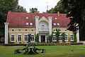
Manor house Koppelsberg (Kopanino)

traffic
Streets
The Gmina Manowo is conveniently located on the important north-south axis of Landesstraße 11 (former German Reichsstraße 160, now expansion to expressway 11 ). In the southern part, the county road 168 runs through the municipality, which connects the rural regions around Bobolice (Bublitz) and Białogard ( Belgard ).
rails
Since 2004 there has been no direct rail connection for the municipality of Manowo. The railway station in the city of Koszalin is to be used for rail transport . There the two railway lines Stargard in Pomerania - Danzig or Goleniów ( Gollnow ) - Koszalin are reached.
On November 1, 1898, the AG Kleinbahn Köslin-Natzlaff opened a railway line from Köslin (Koszalin) via Manow to Natzlaff (Nacław) in the Schlawe district , where it was extended from the Schlawe district railway to Pollnow (Polanów). Today's municipality was connected to this railway line with five stations: Krettmin (Kretomino), Bonin (Bonin), Manow (Manowo), Seidel (Wyszewo) and Viverow (Wierwiórowo).
From November 1, 1905, another small railway branched off to the south in Manow and led via Schwellin (Świelino) to Belgard (Białogard). The stations Finkenborn (Przybyradz), Wilhelmsthal (Żabowa), Grünhof (Zacisze) and Roßnow (Rosnowo) were located on this route in the area of today's municipality.
In some cases, both lines continued to be operated by the Polish State Railways after 1945 , until they were finally closed in 2004.
literature
- Ludwig Wilhelm Brüggemann : Detailed description of the current state of the Königl. Prussian Duchy of Vor and Hinter Pomerania . Part II, Volume 2: Description of the court district of the Royal. State colleges in Cößlin belonging to the Eastern Pomeranian districts . Stettin 1784, pp. 573-574, paragraph 63.
- Heinrich Berghaus : Land book of the Duchy of Pomerania and the Principality of Rügen . Part III, Volume 1, Anklam 1867, pp. 375-377.
- Ernst Müller, The Evangelical Clergy of Pomerania from the Reformation to the Present , Part 2, Stettin, 1912
Web links
- The community of Manow in the former Köslin district in Pomerania (Gunthard Stübs and Pomeranian Research Association)
- Manow District (Rolf Jehke, 2012)
- Website of Gmina Manowo (Polish)
Individual evidence
- ↑ population. Size and Structure by Territorial Division. As of June 30, 2019. Główny Urząd Statystyczny (GUS) (PDF files; 0.99 MiB), accessed December 24, 2019 .
