
Courchavon
| Courchavon | |
|---|---|
 |
|
| State : |
|
| Canton : |
|
| District : | Porrentruy |
| BFS no. : | 6783 |
| Postal code : | 2922 |
| Coordinates : | 571211 / 254612 |
| Height : | 407 m above sea level M. |
| Height range : | 399–606 m above sea level M. |
| Area : | 6.19 km² |
| Residents: | 294 (December 31, 2018) |
| Population density : | 47 inhabitants per km² |
| Website: | www.courchavon-mormont.ch |
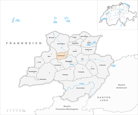
 Courchavon |
|
| Location of the municipality | |
  |
|
Courchavon is a municipality in the Porrentruy district in the canton of Jura in Switzerland . The former German name Vogtsburg is no longer used today.
geography
Courchavon is 407 m above sea level. M. , 3 km northwest of the district capital Porrentruy (air line). The former street line village extends in the valley of the Allaine , in the Ajoie (German Elsgau ).
The area of the 6.2 km² municipal area covers a section of the relatively narrow Allaine valley and extends to the often wooded surrounding Tafeljura heights of the Ajoie. In the east the area extends in the Bois de Sapins (up to 530 m above sea level ), in the west on the plateau of Bure, in which several small valleys are deepened that open to the Allaine. The highest point of the community is 610 m above sea level. In 1997, 5% of the municipal area was settled, 60% forest and woodland, 33% agriculture and around 2% was unproductive land, which is part of the Bure arsenal.
Courchavon includes the hamlet of Mormont , 533 m above sea level. M. in a valley on the eastern roof of the height of Bure, as well as some individual farms. Courchavon's neighboring municipalities are Porrentruy , Bure , Basse-Allaine and Coeuve .
population
With 294 inhabitants (as of December 31, 2018) Courchavon is one of the smaller communities in the canton of Jura. 95.6% of the residents are French-speaking, 3.4% German-speaking and 0.7% Portuguese-speaking (as of 2000). The population of Courchavon was 306 in 1850 and 311 in 1900. In the course of the 20th century, the population always fluctuated between 270 and 320 people.
economy
The village, which is still dominated by agriculture , had something of a watch industry in the 19th century . Apart from agriculture and local small businesses, there are only a few jobs in the village. Many workers are therefore commuters and work in the Porrentruy region.
traffic
- Courchavon is located on the busy main road 6 from Porrentruy via the Boncourt border crossing to Belfort or Montbéliard in France . Since the opening of the section of the A16 motorway from Boncourt to Porrentruy, the village has been relieved of through traffic.
- On September 23, 1872, the Porrentruy – Delle railway with a station in Courchavon was opened by the Chemin de fer Porrentruy – Delle (PD) railway company.
history
Finds of two flint stones prove the presence of humans in the municipality of Courchavon as early as the Stone Age . The village is first mentioned in 1279 as Corchavon . The name probably goes back to the court of a man with the Latin name Calvus . Courchavon shared the checkered history of the Ajoie, which came to the Principality of Basel for the first time in 1271 . From the 16th to the 18th century it was part of the Courtedoux Meieramt together with Mormont . During the Thirty Years War the place was destroyed in 1635.
From 1793 to 1815 Courchavon belonged to France and was initially part of the Département du Mont-Terrible , from 1800 it was linked to the Département Haut-Rhin . By decision of the Congress of Vienna , the place came to the canton of Bern in 1815 and on January 1, 1979 to the newly founded canton of Jura.
Courchavon was originally involved in the Basse-Allaine merger project. In June 2007, however, the community rose for fiscal reasons. The community founded on January 1, 2009 therefore only consists of the towns of Buix , Courtemaîche and Montignez .
Attractions
- The parish church of Saint-Jean was built in 1844–45. In a side chapel she has a Madonna and Child from the 13th century, which is one of the most beautiful Gothic statues of Our Lady in Switzerland.
- The Tour de Mormont, the late Gothic bell tower of a church from 1628 that was demolished in the 19th century, stands in an elevated position above the village .
- Also nearby are the ruins of the former Châtelvouhay castle, which was inhabited in the 13th and 14th centuries. The Saint-Nicolas de Flüe chapel, built in 1974, is located in the hamlet of Mormont.
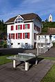
photos

railway station
Primary school building

Tour de Mormont

Gîte la Bergerie à Mormont

Chapelle Saint Nicolas de Flüe à Mormont


Web links
- Dominique Prongué: Courchavon. In: Historical Lexicon of Switzerland .
- Information about Courchavon (French)
- Courchavon website (French)
Individual evidence
- ↑ Permanent and non-permanent resident population by year, canton, district, municipality, population type and gender (permanent resident population). In: bfs. admin.ch . Federal Statistical Office (FSO), August 31, 2019, accessed on December 22, 2019 .
All | La Baroche | Basse-Allaine | Beurnevésin | Boncourt | Bonfol | Bure | Clos du Doubs | Coeuve | Cornol | Courchavon | Courgenay | Courtedoux | Damphreux | Fahy | Fontenais | Grandfontaine | Haute-Ajoie | Lugnez | Porrentruy | Vendlincourt
Former parishes: Asuel | Bressaucourt | Buix | Charmoille | Chevenez | Courtemaîche | Damvant | Fregiécourt | Miécourt | Montenol | Montignez | Montmelon | Montvoie | Ocourt | Pleujouse | Réclère | Roche-d'Or | Rocourt | Seleute | Saint-Ursanne
Canton of Jura | Districts of the Canton of Jura | Municipalities of the Canton of Jura