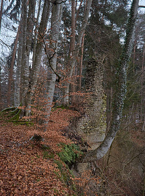
Burgrest Neusummerau
| Burgrest Neusummerau | ||
|---|---|---|
| Creation time : | 1200 to 1300 | |
| Castle type : | Hilltop castle | |
| Conservation status: | Foundation walls | |
| Standing position : | Count | |
| Place: | Neukirch- Summerau | |
| Geographical location | 47 ° 38 '15 " N , 9 ° 41' 53.9" E | |
| Height: | 495 m above sea level NHN | |
|
|
||
Burgrest Neusummerau describes the ruins of a hilltop castle east of the hamlet of Summerau on the way to Flunau in the municipality of Neukirch in the Lake Constance district in Baden-Württemberg .
location
The castle rest of Neusummerau is 495 m above sea level. NHN above the hamlets Summerau and Flunau on an impact slope about 65 meters above the Argen .
history
The castle was probably built as an ancestral castle by the Lords of Summerau in the second half of the 13th century . The Neusummerau is probably older than the Altsummerau Castle near Tettnang- Rattenweiler . In 1171 Kuno, Friedrich and Albert von Summerau appear as witnesses in a document issued for the Salem monastery . In 1222/30 the castrum Sumerow was first mentioned in a document in the presence of the brothers Albert, Kuno and Heinrich von Summerau . The castle finally passed into the possession of the Episcopal Constance, which King Albrecht confirmed in 1298 with Bishop Heinrich II von Klingenberg . In 1309 the castle is owned by the Counts of Montfort , in 1354 a certificate of division distinguishes between the Burckh to the Nideren Summeraw and the upper Summerau . In 1430 the castle seems to have been inhabited by a Sürg zu Sürgenstein , according to a document he sat ze Nuwensummro . Further mentions are not known.
investment
From the former castle complex, in addition to a higher wall corner in the east of the core castle , remains of masonry are still preserved in the ground. Presumably these are the remains of a curtain wall and a building. A remnant of a corner wall in the western area of the main castle, which is still known at the time, has been lost after the gravel embankment slipped in an unexpectedly large volume towards the Argen not far to the south . The remains of the castle are at risk from further landslides, as the steep slope to the Argen, which once secured the south side of the castle, cannot be stabilized. Since then, the road there has only been passable for pedestrians in a sporty way and, since it was the only access to Flunau, it was replaced at short notice by a new or expansion of a path over a ridge to the K7778 surrounding the castle hill to the north.
The facility, located on a slope edge, was protected in the west by an artificially steep slope, in the north and east by section trenches and ramparts that are still well preserved today . In the north the remains of the fortifications can still be seen up to the embankment of a brook running roughly parallel to the Argen. The ramparts and ditches are partly sanded or broken by paths, but partly also very well preserved.
See also: Altsummerau ruins
literature
- Max Miller , Gerhard Taddey (ed.): Handbook of the historical sites of Germany . Volume 6: Baden-Württemberg (= Kröner's pocket edition . Volume 276). 2nd, improved and enlarged edition. Kröner, Stuttgart 1980, ISBN 3-520-27602-X .
- Alois Schneider: Castles and fortifications in the Lake Constance district . Ed .: Landesdenkmalamt Baden-Württemberg (= Fund reports from Baden-Württemberg . Volume 14 ). 1st edition. E. Schweizerbart'sche Verlagsbuchhandlung, Stuttgart 1989, ISBN 3-510-49114-9 , pp. 602-604 .
Web links
- Entry by Jens Friedhoff zu Neu-Summerau in the scientific database " EBIDAT " of the European Castle Institute
- Images and texts about castles and castle ruins in the Argental at argen-blicke.de
Individual evidence
- ^ Alois Schneider: Castles and fortifications in the Lake Constance district . Ed .: Landesdenkmalamt Baden-Württemberg (= Fund reports from Baden-Württemberg . Volume 14 ). 1st edition. E. Schweizerbart'sche Verlagsbuchhandlung, Stuttgart 1989, ISBN 3-510-49114-9 , pp. 602-604 .


