Nová Bošáca
| Nová Bošáca | ||
|---|---|---|
| coat of arms | map | |

|
|
|
| Basic data | ||
| State : | Slovakia | |
| Kraj : | Trenčiansky kraj | |
| Okres : | Nové Mesto nad Váhom | |
| Region : | Stredné Považie | |
| Area : | 33.440 km² | |
| Residents : | 1,059 (Dec. 31, 2019) | |
| Population density : | 32 inhabitants per km² | |
| Height : | 306 m nm | |
| Postal code : | 913 08 | |
| Telephone code : | 0 32 | |
| Geographic location : | 48 ° 53 ' N , 17 ° 48' E | |
| License plate : | NM | |
| Kód obce : | 506303 | |
| structure | ||
| Community type : | local community | |
| Administration (as of November 2018) | ||
| Mayor : | Ján Žucha | |
| Address: | Obecný úrad Nová Bošáca č. 79 913 08 Nová Bošáca |
|
| Website: | www.novabosaca.sk | |
| Statistics information on statistics.sk | ||
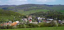
Nová Bošáca is a municipality in the west of Slovakia with a population of 1,059 (December 31, 2019), which for Nové Mesto nad Váhom District ( Trenčín Region belongs).
geography
Nová Bošáca is located in the White Carpathians on the Bošáčka brook under the Veľký Lopeník mountain , bounded in the north by the state border between Slovakia and the Czech Republic , while to the south the valley merges into the northwestern foothills of the Danube lowlands . The center (Predbošáčka, 306 m nm ) is 17 kilometers from Nové Mesto nad Váhom and 30 kilometers from Trenčín .
List of settlements
|
|
|
history
The present municipality was founded in 1950 by spinning off the 23 settlements from Bošáca , after they had far exceeded the population of the core town in previous years. Today, smaller settlements / individual farms and those in remote valleys have largely given way to weekend houses, so-called chatas.
The Roman Catholic Cyril and Methodist Church was completed in 1971.
Web links
- Official site (Slovak)

