
Oberlienz
|
Oberlienz
|
||
|---|---|---|
| coat of arms | Austria map | |
 |
|
|
| Basic data | ||
| Country: | Austria | |
| State : | Tyrol | |
| Political District : | Lienz | |
| License plate : | LZ | |
| Surface: | 33.76 km² | |
| Coordinates : | 46 ° 51 ' N , 12 ° 44' E | |
| Height : | 756 m above sea level A. | |
| Residents : | 1,461 (Jan 1, 2020) | |
| Population density : | 43 inhabitants per km² | |
| Postal code : | 9903 | |
| Area code : | 04852 | |
| Community code : | 7 07 20 | |
| NUTS region | AT333 | |
| Address of the municipal administration: |
Oberlienz 30 9903 Oberlienz |
|
| Website: | ||
| politics | ||
| Mayor : | Huber Martin | |
|
Municipal Council : (2010) (13 members) |
||
| Location of Oberlienz in the Lienz district | ||
  |
||
| Source: Municipal data from Statistics Austria | ||

Oberlienz is a municipality with 1,461 inhabitants (as of January 1, 2020) in the Lienz district in Tyrol , Austria . Oberlienz lies on the alluvial cone of the Schleinitzbach, on the edge of the Lienz basin, in the Iseltal . The community in the judicial district of Lienz is formed by the districts of Oberlienz and Oberdrum, which have now grown together, and the village of Glanz on the opposite side of the valley.
geography
Community structure
| Population distribution | |||||
|---|---|---|---|---|---|
| fraction | population | ||||
| Oberlienz | 856 | ||||
| Upper drum | 442 | ||||
| shine | 140 | ||||
From an administrative point of view, Oberlienz is divided into the three cadastral communities of Glanz, Oberdrum and Oberlienz. The cadastral municipality of Glanz includes the north-western part of the municipality with the village of Glanz and extends from Krassbach to Rötenbach in the south. In the east the cadastral community reaches just up to the Isel, in the west to the Lavantpitzen and the Böse Weibele. The cadastral municipality of Oberlienz covers the area east of the Rötenbach and the cadastral municipality of Glanz up to the municipal boundary of Lienz and extends beyond the Isel in the north, including the village of Oberlienz. The part to the north of it belongs to the cadastral municipality of Oberdrum.

mountains
Oberlienz has small shares in the Schober group in the north . Since the municipal boundary only reaches up to around 2200 meters, Oberlienz does not have any significant elevations in the north. In the south of Oberlienz, however, there are several Lienz local mountains, the Villgraten Mountains . These are the Hintere- and Vordere Lavantspitze, the Böse Weibele ( 2521 m ), the Bloßenegg ( 2146 m ) and the Hochstein ( 2057 m ).
Waters
Oberlienz is divided by the Isel into a western part with the town of Glanz and an eastern part with the towns of Oberdrum and Oberlienz. On the border with Ainet , the Krassbach forms part of the municipal boundary , while the Mühlbach runs through the village of Glanz. To the south of the village of Glanz, the Rötenbach and Urschenbach flow into the Isel, with the Urschenbach partially fed by the Blösenbach. On the left side of the Isel, Oberlienz on the border with Ainet in the upper reaches has a short portion of the Daberbach . The villages of Oberdrum and Oberlienz themselves are traversed by the Schleinitzbach, which has a western tributary with the Morinitzbach.
climate

Since there is no measuring station in Oberlienz, exact records of the community's climate are missing. However, due to the proximity of the settlements to the weather station in the district capital Lienz, it is comparable with the climatic data measured there. The coldest month of the year in the Lienz basin is January, the highest temperatures are measured in the summer months of July and August. The highest rainfall also falls in the summer months, with the month of October being almost as rainy. Fog rarely occurs in the Lienz Basin, but in winter, due to inversion weather conditions, mighty cold-air lakes form .
history
Name story
The origins of the three Oberlienz districts are each in different languages. While Oberlienz is of Celtic origin, the place name Oberdrum has German and the place name Glanz Slavic roots. The name Lienz is probably derived from the Celtic word lokina and can be translated as "arched area". The Celtic word was linguistically transformed over time by the presence of the Romans and Slavs and has its origin in the bend of the Puster Valley into the Drau Valley. Oberdrum, on the other hand, is a German word creation and goes back to the Middle High German word drum or trum , which can be translated as “piece” or “end piece”. The place name gloss is derived from Slavic and goes back to the Old Slavic word klan (i) c (i) (New Slavic klanc ), which denotes a ravine .
Prehistory and Antiquity
Although there were permanent settlements in the Lienz Basin as early as the late Neolithic , only individual finds indicate the presence of people in pre-Roman times in what is now the municipality of Oberlienz. The oldest find is a bronze sickle fragment from the urn field culture (1200–750 BC), smaller ceramic fragments from the Hallstatt period were discovered under the foundations of the parish church. During the Latène period, the area of East Tyrol came under the influence of the Fritzens-Sanzeno culture, with the remains of settlements from this time being discovered on the nearby Lienzer Schlossberg. For Oberlienz, however, no settlements from this time have been found. During the 2nd century BC The Celts incorporated the Lienz Basin into their dominion and integrated East Tyrol around 100 BC. In the Kingdom of Noricum. Around 15 BC Noricum fell peacefully to the Roman Empire and the Romans established the city of Aguntum in the Lienz basin . Inspired by the founding of the city, the first demonstrable settlement also arose in the municipality of Oberlienz. Excavations in the hamlet of Lesendorf in 1901 uncovered the foundations of an approximately 30 m long building with simple mosaic floors and extensive vaults of a hypocaust system. Floor slabs and pieces of marble as well as ceramic and glass fragments were also found. However, parts of the finds that were brought to the Landesmuseum Innsbruck have been lost. After inspections of the site and individual finds during inspections, the Institute for Archeology at the University of Innsbruck carried out a georadar measurement in 2007 and 2008, which proved the walls of a villa rustica . The complex was surrounded by an almost rectangular wall and, in addition to an elongated rectangular building with a side length of over 70 m, the manor house, also housed numerous ancillary and farm buildings. The complex also included a bathhouse with a semicircular apse and underfloor heating. Due to the size of the plant, the complex probably also produced for the regional market beyond its own needs.
middle Ages
After Germanic tribes had repeatedly devastated Aguntum from the 3rd century AD, in 610 a decisive battle broke out at Aguntum between the Bavarians advancing from the north and the Slavs advancing from the east . The victorious Slavs subsequently settled the Lienz basin and the Isel region and incorporated the area into the Principality of Carantania . In the 8th century Carantania came under the control of the Duchy of Bavaria and the Lienz basin and the Isel region were gradually settled by Bavarian colonists. Duke Tassilo III. also initiated the Christianization of the region in 769 with the establishment of the San Candido monastery . As a result, the language and culture of the Slavs were gradually supplanted by the colonists. The area of Oberlienz imputed Emperor Charlemagne 811 with the field left the Drava Church of the Archdiocese of Salzburg . Since the Bavarians were able to gradually expand their sphere of influence up to the middle of the 10th century, Emperor Otto II separated the Duchy of Carinthia from Bavaria, which extended into the Tauern region in the west and included the Lienz basin. The west of Carinthia belonged to the County of Lurngau in the High Middle Ages and was ruled by the Counts of Gorizia from the 12th century until the beginning of the modern era , who extended their county from their center of power Lienz to the Adriatic coast. As a result, the Counts of Gorizia had their possessions in Carinthia and the Pustertal recorded in a land register in 1299 , which for the first time recorded more precise data on the settlement and economic structure. The area of today's municipality of Oberlienz included nine manors in 1299, which were owned by the Counts of Gorizia. Three of the manorial estates were in shine, two courtyards in Oberdrum, one courtyard in Lesendorf and three courtyards in Oberlienz, although the name Oberlienz for the settlement around the Church of the Assumption of the Virgin Mary was only adopted later. Around 1300 today's Oberlienz, however, was called Mitteldorf. In the Görzer Urbar, in addition to the estates and their owners, the interest payments were also recorded, with the estates mainly paying interest on cheese and grain (rye, wheat and oats). In addition, the goods also had to deliver animals (sheep, goats and pigs), poppy seeds, beans, lard and money. In addition, the majority of the farmers were subject to the unfavorable free pen law , which meant that the subjects of the Gorizia gave much higher taxes, while in Tyrol around 1500 the heritable building right was almost exclusively used.
Early modern age
After the death of Count Leonhard von Görz, the Görz possessions fell to Maximilian I in 1500 , who incorporated them into the County of Tyrol in February 1501. Maximilian only retained the sovereignty and in 1501 sold the county of Gorizia to Michael von Wolkenstein-Rodenegg . Due to the sale of the rule, however, the planned conversion of the free pen right into inheritance failed . Under the auspices of the Wolkensteiners, a complete record of all farms and manors was created for the first time with the property tax cadastre of the Lienz Regional Court in 1575, whereby a total of 71 farms were registered for today's municipality of Oberlienz. 27 farms were in Oberlienz, 28 in Oberdrum and 16 in Glanz. The most important landlord in the three ranks was the Lienz rulership, which was the former landlord property of the Gorizia, which had fallen to the Counts of Wolkenstein in 1501. In 1575 they owned six farms each in Oberlienz and Glanz and ten farms in Oberdrum. Furthermore, numerous church institutions were found among the landlords, such as the parish sanctuary St. Andrä in Patriasdorf (8 courtyards), the Dominican monastery Lienz (6 courtyards) and the Brixen cathedral chapter (3 courtyards). While the sovereign rule of Lienz and the ecclesiastical institutions belonged to the permanent landlords, the ownership structure of the secular and private landlords often changed and showed no continuity over the centuries. After the bankruptcy of the Wolkensteiner counts in 1653, the Haller Damenstift acquired the Lienz district court with the Rotten Oberlienz, Oberdrum and Glanz.
population
Population structure
Population development
|
In 2008, 1,447 people lived in the municipality of Oberlienz. According to the 2001 census, 98.3% of the population were Austrian citizens (Tyrol: 90.6%); by the beginning of 2008 the value had only fallen slightly to 97.8%. In 2001, 97.4% of the population (Tyrol: 83.4%), 0.7% were Protestant , and only 1.1% had no religious beliefs in the Roman Catholic Church .
The average age of the community population in 2001 was well below the national average. 20.2% of the inhabitants of Oberlienz were younger than 15 years (Tyrol: 18.4%), 61.1% between 15 and 59 years old (Tyrol: 63.0%). The proportion of residents over 59 years of age was exactly the national average at 18.6%. As a result, the average age of the population of Oberlienz rose significantly. The proportion of people under the age of 15 fell to 17.6%, while the proportion of people between the ages of 15 and 59 rose to 65.2%. At the same time, however, the proportion of people over 59 years of age fell to 17.1%. According to their marital status, 52.2% of the inhabitants of Oberlienz were single, 40.3% married, 4.9% widowed and 2.0% divorced.
Population development
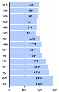
The population of Oberlienz fell by around 10% from the middle of the 19th century to the end of the First World War. After that, an almost continuous increase in population began. The strongest growth occurred in the interwar period, when the number of inhabitants rose by around 13% between 1923 and 1934 and exceeded the 1000 inhabitant mark for the first time. After the end of World War II, there was strong growth, especially in the 1960s, as a result of which the population increased by 12% in that decade. Since the beginning of the 21st century, the population has stagnated at a high level, with 1,465 inhabitants reaching the highest population level to date in early 2005. While the birth balance in Oberlienz has been slightly positive since 2002, the municipality has a negative migration balance.
coat of arms
The blazon reads:
- A shield divided diagonally by blue and red, inside a golden rose.
The colors of the municipal flag were set in blue and red.
The Oberlienz coat of arms was awarded to the municipality on May 30, 1972 by the Tyrolean state government. The colors go back to the centuries that Oberlienz belonged to the county of Gorizia . The rose on the municipal coat of arms, on the other hand, refers to the neighboring Lienz, which in the early modern period only had the rose in its coat of arms and administered the surrounding area. In addition, the rose symbolizes the floral decoration of the municipality of Oberlienz, as flower village was awarded.
economy
Workplaces and employees
The census of workplaces carried out as part of the census in 2001 revealed 29 workplaces with 257 employees (excluding agriculture) in Oberlienz, 89% of whom were employed. The number of workplaces had risen by five companies (plus 21%) compared to 1991, and the number of employees rose by as much as 108 people (73%). The most important branch of the economy in 2001 was the construction industry with around 27% of the employees in the municipality, followed by the production of goods (24% of the employees) and the real estate / business services sector (18% of the employees). However, the sizes of businesses in trade and commerce in the municipality of Oberlienz are very small. In 2001 there were only three companies with 20 or more employees. Of the 625 employed residents of Oberlienz, only 115 people were employed in Oberlienz in 2001. 510 had to commute to work. Of the out-commuters, 66% had their place of work in the neighboring urban center of Lienz. Another 16% had found a job in the rest of the district, another 7 or 6% commuted to North Tyrol or another federal state, and 20 people went abroad.
The population resident in Oberlienz is predominantly employed in the service industry. In 1991 around 55% of the resident population had their job in this area, 33% worked in industry, trade or construction. Only 12% or 73 people were employed in agriculture. As in all agricultural communities, the employment figures in the economic sectors had shifted significantly. In 1951, 78% of those in employment from Oberlienz were still employed in agriculture (470 people), only 16% were employed in trade and construction and 5% in the service sector.
tourism
After Oberlienz was originally affiliated with the Lienzer Verkehrsverein, the municipality founded the “Verkehrsverein Oberlienz” in December 1964 due to the lack of financial support from the Lienz tourism association. As a result, the number of beds increased between 1962 and 1972 from 352 to 700 beds. Supported by the opening of the Felbertauern tunnel, there was also a rapid increase in overnight stays, which more than doubled from 18,197 to 38,970 between 1962 and 1972. After that, however, a continuous downturn began. In 1996 the number of overnight stays and beds had already fallen below the level of 1962 and the downturn continued into the 21st century. Today tourism in Oberlienz is of little economic importance compared to the Lienz district. The municipality can only count around 10,000 overnight stays per year, while Kals am Großglockner , which is roughly the same size, has more than 12 times as many overnight stays. Winter tourism is particularly weak. In the winter of 2007/08 there were only 1,330 overnight stays. This is the second lowest value in the entire district. While the number of overnight stays in winter has remained constant since the turn of the millennium, the number of overnight stays fell by around 10% in summer. Of the 8,910 overnight stays in summer 2008, 44% were from Austrians, 41% from Germans and 3% each from Dutch and Belgians.
Today, like all other East Tyrolean municipalities, the municipality belongs to the East Tyrol Tourist Association, with Oberlienz being organized in the "Lienzer Dolomites Holiday Region". In the community, which is located on the Iseltal-Radweg, there was a number of guest houses and private room renters as well as a three-star hotel.
education
The first documentary evidence of a village school in Oberlienz dates from 1678, when the schoolmaster Mathes Maurer was first mentioned as a teacher. Evidence for the location of the school is only available around 100 years later. From 1777 the students were taught in the Untermetzgerhaus, after the sale of the building in 1787 also in the teacher's room. In 1810 the school was moved to Widum. The increasing shortage of space led to official instructions to eliminate this, which is why the municipality of Oberlienz bought the Moalerhaus and set up a two-class school there. However, since this school quickly became too small, a new, also two-class, school was built in the Kramer Garden between 1910 and 1911. On the other hand, the authorities rejected Oberdrums' wish for their own elementary school. The steadily increasing number of pupils led to the introduction of further classes, but the increasing lack of space made a new building necessary. The new school was planned with eight classes and completed in 1968. Due to the dissolution of the elementary school upper level and the assignment of the pupils from Oberlienz to the main school district Lienz, numerous empty classes were created in the Oberlienz elementary school. These were used at times by the Lienz Agricultural College, today they are mainly used by associations. While the children from Oberdrum attended the elementary school in Oberlienz, Glanz had had its own elementary school since 1837. The old school building in shine was extended in 1909 before it was replaced by a new building in 1963.
While the elementary school in Oberlienz was attended by 73 children in the 2005/2006 school year, only 10 pupils were enrolled in the Glanz elementary school in the 2006/2007 school year. Since the 1970s, children from the municipality of Oberlienz have had to move to Lienz to attend secondary school, where the closest secondary schools are also located. There is a kindergarten in Oberlienz and Glanz to look after younger children. While the Oberlienz kindergarten is open on weekday mornings, the Glanzer kindergarten can only be attended a few hours per week.
Security and Healthcare
With regard to health care, Oberlienz is organized together with the communities of Amlach , Leisach , Tristach , Gaimberg , Ainet , Schlaiten and St. Johann im Walde in the social district of Lienz / Land. In the health district, for example, health services such as elderly and care assistance, home and household help and meals on wheels are organized.
Culture and sights
Attractions
There are numerous objects protected by the Monument Protection Act in the municipality of Oberlienz. These include the Oberlienz parish church, the Oberdrum branch church and the Helenenkirche, as well as four chapels, the Widum, a wayside shrine and several (formerly) commercial buildings that can be viewed in the Oberlienz open-air museum .
Mention should be made of the Anton Baumgartner memorial workshop in Unterpetererhof, Oberdrum 101, where works by the artist are exhibited and talented young wood sculptors can work.
Sports
The local sports club Union Oberlienz was only founded in 1972 and is a member of the sports umbrella organization of the Sportunion . After the founding of the association, the sections football, tobogganing, table tennis, skiing, gymnastics, curling and cross-country skiing / mountain sports were created, in which more than 300 people are active. The table tennis section played for years in class A, the highest Tyrolean league, the soccer section was only able to temporarily settle in 1st class A and is currently (2009/10 season) in 2nd class A. The soccer section belongs like all East Tyrolean clubs to the Carinthian Football Association and play their home games on the sports field approved in 1980. The most successful athlete from Union Oberlienz is Klaus Gstinig, who took 2nd place at the Triathlon World Championships in 1994 and became World Champion in 1995.
Personalities
- Franz Kranebitter (1906–1977): Member of the National Council, founder of the Osttiroler Bote , "father" of Felbertauernstrasse ;
- Anton Baumgartner (1952–2009): artist (sculptor), and professor at the technical school for arts and crafts and design Elbigenalp ;
- Paula Eisenmann (* 1953): Member of the Tyrolean Parliament;
- Alois Gutwenger (1884–1947): headmaster, chairman of the rifle company, honorary citizen of the municipality of Oberlienz;
- Alois Mattersberger: Mayor 1968–1998, honorary citizen of the municipality of Oberlienz;
- Klaus Schneeberger (* 1950): politician, mayor of Wiener Neustadt since 2015 ;
- Luise Oberhauser (* 1958): writer, doll designer;
- Emerentiana Pichler († 1680): known as the "Perlog Witch" and executed in Lienz in 1680;
- Paula Lobenwein: athlete, chairwoman of the East Tyrolean Disabled Sports Association;
- OSR Ernst Schneider (* 1934): headmaster, choir director, organist and conductor, bearer of the Tyrolean merit mark;
literature
- Emma Totschnig, Peter Lobenwein: Chronicle of Oberlienz. Innsbruck 1978 [Tiroler Landesarchiv (Ed.): Ortschroniken No. 37]
- Oberlienz in the past and present. Oberlienz 1998
Web links
- 70720 - Oberlienz. Community data, Statistics Austria .
Individual evidence
- ↑ a b c d e f Statistics Austria
- ↑ Regional studies East Tyrol p. 108
- ↑ Oberlienz in the past and present p. 43
- ↑ Oberlienz in the past and present p. 9 f.
- ↑ Geophysical prospection of Roman villa complexes in East Tyrol , accessed on August 23, 2013
- ↑ Florian Martin Müller : Archaeological prospection for the settlement of Oberlienz in Roman times , Forum Archaeologiae - journal for classical archeology. 54 / III / 2010
- ↑ Römischer Gutshof tracked down with georadar in East Tyrol , ipoint online information portal of the University of Innsbruck, August 27, 2008
- ↑ State Statistics Tyrol (VZ 2001) (PDF file; 3.9 MB)
- ↑ Municipality of Oberlienz ( Memento of the original from July 23, 2007 in the Internet Archive ) Info: The archive link was inserted automatically and has not yet been checked. Please check the original and archive link according to the instructions and then remove this notice. Coat of arms and names, accessed June 28, 2009
- ↑ Oberlienz in the past and present, p. 139
- ^ Office of the Tyrolean provincial government, Tyrolean provincial statistics
- ^ Municipality of Oberlienz , accessed on July 25, 2009
- ^ Municipality of Oberlienz , accessed on July 25, 2009
- ^ Social district Lienz-Land
- ↑ Oberlienz in the past and present, pp. 292–298
Abfaltersbach | Ainet | Amlach | Anras | Assling | Ausservillgraten | Dölsach | Gaimberg | Heinfels | Hopfgarten in Defereggen | Innervillgraten | Iselsberg-Stronach | Kals am Großglockner | Kartitsch | Lavant | Leisach | Lienz | Matrei i. O. | Nikolsdorf | Nussdorf-Debant | Oberlienz | Obertilliach | Prägraten am Großvenediger | St. Jakob in Defereggen | St. Johann im Walde | St. Veit in Defereggen | Schlaiten | Sillian | Streets | Thurn | Tristach | Untertilliach | Virgen
Cadastral municipality and locality / parliamentary group: gloss | Upper drum | Oberlienz
Village: Lesendorf · Oberdrum · Oberlienz | Hamlet: pits | Rottenberg: gloss · Except Krass · Außerm Mühlbach · Greinhof · Pölland · Stoeckl · draft · Bottom Forest | Other location: St. Helena
Counting district: Oberlienz