
Paraná
| Estado do Paraná Paraná |
|||
|---|---|---|---|
|
|||
| Coordinates | 25 ° S , 52 ° W | ||
 Location of the state of Paraná in Brazil Location of the state of Paraná in Brazil
|
|||
| Symbols | |||
|
|||
| founding | 1889 (as a state, 1853–1889 province of Paraná) | ||
| Basic data | |||
| Country | Brazil | ||
| State | Paraná | ||
| Capital | Curitiba | ||
| ISO 3166-2 | BR-PR | ||
| Região intermediária | 6 (since 2017) | ||
| Região imediata | 29 (since 2017) | ||
| structure | 399 municipalities | ||
| Waters | Rio Paraná | ||
| climate | subtropical, Cfa, Cfb and Cwa | ||
| surface | 199,307.9 km² | ||
| Residents | 10,444,526 (2010, last census ) | ||
| density | 52.4 Ew. / km² | ||
| estimate | 11,433,957 Ew. (July 1, 2019) | ||
| Time zone | UTC −3 | ||
| Website | www.pr.gov.br (Brazilian Portuguese) | ||
| politics | |||
| governor |
Ratinho Júnior ( PSD ) - since January 1, 2019 Deputy Governor: Darci Piana ( PSD ) Senators: 3 MPs: 30 State MPs : 54 |
||
| economy | |||
| GDP | 348100000000 R $ 31,411 R $ per capita (2014) |
||
| HDI | 0.749 (high) (2010) | ||


The state of Paraná (short PR ; officially Portuguese Estado do Paraná ) is located in the south of Brazil . It is divided into six main regions with 399 Munizipe (municipalities).
geography
The area is around 199,308 km², the population was estimated on July 1, 2019 at 11,433,957 inhabitants. The population density in 2010 was around 52 people per square kilometer.
The state borders Argentina and Paraguay to the west . Paraná is bounded in the east by the Atlantic Ocean , in the north by the Brazilian states of Mato Grosso do Sul and São Paulo , in the south by the state of Santa Catarina . It is named after the Paraná river , which forms its western border.
The capital is Curitiba . It has given itself the nickname "Capital of Ecology" and is well known a. a. through an exemplary public transport system.
Other cities in Paraná are u. a. Londrina , Maringá , Ponta Grossa , Cascavel , and Foz do Iguaçu . The famous Iguaçu waterfalls are also on the territory of this state.
History and culture

As early as 1811, the former Comarca de Coritiba had been striving for autonomy , parliamentary debates took place from 1843, but it took another 10 years until the former 5th Comarca was spun off as the Province of Paraná from the Province of São Paulo by Decree No. 704 of August 26, 1853 and formed the basis of the territory of what is now the state.
In the 19th century, numerous immigrants from Italy, Poland , Germany, Russia and the Ukraine settled in the comarca and the province , who first settled in the coastal areas and then pushed further into the hinterland.
Indigenous myths are not passed down; they were adapted from other regions. Afro-Brazilian influences are only slight.
politics
In the gubernatorial elections in Brazil in 2018 for the executive was Ratinho Júnior of PSD elected for a term of office from 2019 to 2023 for the 57th governor.
The legislature is exercised by 54 elected representatives in the Legislative Assembly of Paraná . The state sends 30 federal representatives to the Chamber of Deputies and three federal senators to the federal senate of the national congress .
Cities
The ten most populous cities of the 399 municípios Paranás are according to the 2010 census of the IBGE with estimates of the population as of July 1, 2018:
![]() Map with all coordinates of the cities section : OSM
Map with all coordinates of the cities section : OSM
| # | Munizip | Municipality code |
Population census 2010 |
2018 estimate |
|
|---|---|---|---|---|---|
| 1 |
Curitiba |
4106902 | 1,751,907 | 1,917,185 |

|
| 2 |
Londrina |
4113700 | 506.701 | 563,943 |

|
| 3 |
Maringá |
4115200 | 357.077 | 417.010 |

|
| 4th |
Ponta Grossa |
4119905 | 311,611 | 348.043 |

|
| 5 |
Cascavel |
4104808 | 286.205 | 324,476 |

|
| 6th |
São José dos Pinhais |
4125506 | 264.210 | 317,476 |

|
| 7th |
Foz do Iguaçu |
4108304 | 256.088 | 258,823 |

|
| 8th |
Colombo |
4105805 | 212,967 | 240,840 |

|
| 9 |
Guarapuava |
4109401 | 167,328 | 180,334 |
|
| 10 |
Paranaguá |
4118204 | 140,469 | 153,666 |
|
Population development from 1872
Source: IBGE (figure for 2019 is only an estimate).

Population density

Ethnic groups
Whites make up about 79% of the population. The white population came to Paraná mostly from European countries as immigrants at the beginning of the 19th century, mostly from Portugal , Poland , Italy , Germany and Ukraine . At the beginning of the 20th century, immigrants from Japan , Lebanon and Syria followed .
Economy and Agriculture
In Paraná u. a. numerous automobile manufacturers built production plants.
With the so-called Terras Roxas, the state has very fertile soils , is Brazil's most important agricultural producer and supplies corn, cotton, wheat, soy, rice, peanuts and beans. Pig and poultry farming are also represented in Paraná , as in the two southern neighboring states of Santa Catarina and Rio Grande do Sul .
Picture gallery

Pinheiros ("Brazilian pine") - the u. a. Araucaria that forms forest in Paraná

Botanical garden in Curitiba

Waterfalls at Iguaçu

View from Caratuva to Pico Paraná (July 2006)
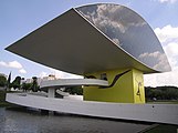
Oscar Niemeyer Museum

Second largest hydropower plant in the world near Itaipu

Bizarre formation in the rocky landscape of Vila Velha

Dutch construction at Carambeí, Paraná
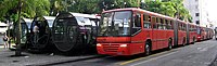
Rede Integrada de Transporte bus stop in Curitiba

The Universidade Federal do Paraná (UFPR), founded in 1912, is the oldest university in Brazil

Praia do Brejatuba in Guaratuba


Web links
- Governo do Paraná (Portuguese)
Individual evidence
- ↑ IBGE : Paraná - Panorama .
- ↑ a b c IBGE : Municípios de Paraná . Retrieved September 4, 2019.
- ↑ Herbert Toledo Martins: Formação e fragmentação do Estado Nacional Brasileiro no período imperial: a criação since província do Paraná . In: Acta Scientiarum. Human and Social Sciences . tape 30 , 2008, p. 9-16 (Brazilian Portuguese, uem.br [accessed August 11, 2018]).
- ↑ Luiz Fernando Tomasi Keepen: A emancipação política do Paraná . In: Gazeta do Povo . December 20, 2008 (Brazilian Portuguese, archive.org [accessed August 11, 2018]).
- ↑ IBGE Censo 2010 - Tabela 1.4 - População nos Censos Demográficos, segundo as Grandes Regiões e as Unidades da Federação - 1872/2010. In: censo2010.ibge.gov.br. IBGE , accessed September 3, 2019 (Brazilian Portuguese).
Acre | Alagoas | Amapá | Amazon | Bahia | Ceará | ( Distrito Federal do Brasil ) | Espírito Santo | Goiás | Maranhão | Mato Grosso | Mato Grosso do Sul | Minas Gerais | Pará | Paraíba | Paraná | Pernambuco | Piauí | Rio de Janeiro | Rio Grande do Norte | Rio Grande do Sul | Rondônia | Roraima | Santa Catarina | São Paulo | Sergipe | Tocantins