Rödlas (Hirschau)
|
Rödlas
City of Hirschau
Coordinates: 49 ° 35 ′ 33 " N , 11 ° 57 ′ 14" E
|
|
|---|---|
| Height : | 524 m above sea level NN |
| Residents : | 23 (1997) |
| Postal code : | 92242 |
| Area code : | 09608 |
|
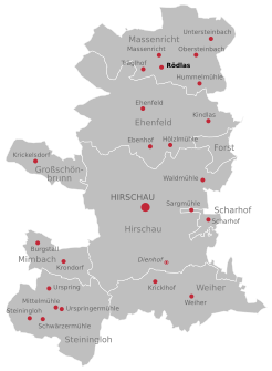
Location of Rödlas in Hirschau
|
|
|
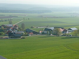
Look at Rödlas from the observation tower of
|
|
Rödlas is a district of the city of Hirschau in the district of Amberg-Sulzbach in the Upper Palatinate in Bavaria, consisting of five properties.
origin of the name
The name Rödlas indicates a clearing.
geography
Geographical location
Rödlas located in the northern city of Hirschau on the border of the district Amberg-Sulzbach for Neustadt an der Waldnaab .
topography
The place Rödlas itself lies at 524 m above sea level. NN. The top of the Rödlasberg belonging to the village is 579 m above sea level. NN.
Natural allocation
Rödlas is located in the north of the Upper Palatinate hill country . Since sheet 154/155 Bayreuth of the single sheets 1: 200,000 for the manual of the natural spatial structure of Germany has not been published, there is no detailed breakdown for the northern part of the Upper Palatinate hill country .
In relevant specialist literature, the geological subunit in which Rödlas is located is referred to as the Kohlberger ridges .
history
It is believed that Rödlas was founded in 1348/1349 before the first great plague wave. "The three Höff von Rödleins" (Rödlas) were first mentioned in a document in the military register of the Hirschau nursing office in 1501.
In a directory by Ignatz Biechl from 1783 and in a directory by Johann W. Melchinger from 1796, Rödlas is mentioned as a village belonging to the Hirschau court , the Amberg rent office and the Regensburg diocese .
The Oberpfälzer Waldverein Massenricht built a game reserve and a forest nature trail in Rödlas in 1970. Also in 1970 the forest association began building a log cabin, the Rödlaser mountain hut.
In 1977 the construction of the Rödlasturm began.
On May 1, 1978 Rödlas was conducted as part of the community mass directivity in the course of municipal reform incorporated into the city Hirschau.
In 1990 the Rödlaser Berghütte was brought into its current form through expansion measures.
Religions
The religious confusion of the 16th and 17th centuries also had an impact in the area around Rödlas. It can be assumed that Rödlas, who has always belonged to the Benefice and later to the Ehenfeld branch , changed denominations several times. In 1628 Rödlas became finally Catholic together with Ehenfeld.
Ehenfeld is still independent as a parish, but has formed a pastoral care unit with Hirschau since 2003.
Culture and sights
Buildings
chapel
In 1950/1951, the first chapel in Rödlas was built as a private chapel by Johann and Magdalena Bogner. The construction of the chapel is based on the vow of a son from the neighboring Bogner estate. In the last weeks of the Second World War, he deserted together with three other soldiers from the Western Front in northern Germany. In just nine days, the four soldiers made it to their homeland without being discovered. After arriving home, he hid on his parents' property for 17 days, even though SS soldiers were quartered there. When the Allies moved in on April 22, 1945, the young man was freed from his predicament. Thereupon he kept his promise: He donated the chapel and entered the monastery.
In 1994 Konrad Bogner had the old chapel demolished and rebuilt in the same place. On June 30, 1996 the newly built chapel "Maria - Hilfe der Christisten" in Rödlas was inaugurated by Auxiliary Bishop Karl Flügel .
Rödlaser mountain hut
The Rödlaser Berghütte in the Rödlas district is owned by the local group of the Upper Palatinate Forest Association . The hut , as the Rödlaser mountain hut is called by the locals, is frequented primarily by recreational guests and hikers who use the hiking trails in the area .
Rödlasturm
The Rödlasturm is a 32 meter high observation tower at 570 m above sea level. NN. Like the mountain hut, the tower was built by the local mass judge group of the Upper Palatinate Forest Association. When the weather is clear, it offers a view of the two basalt cones Parkstein and Rauher Kulm , to the east of the Czech Republic, to the south of Hirschau with Monte Kaolino and Schnaittenbach and to the west of the mountains of Franconian Switzerland . The tower could not be restored with the association's own funds, but this was achieved by placing their antennas there.
Economy and Infrastructure
Rödlas is a starting point for numerous hiking trails, e.g. B. the east line of the Main-Donau-Weg , the Wallenstein-Tilly-Weg or the Naab-Vils-Weg .
Furthermore, two circular hiking trails signposted by the AOVE lead past the Rödlas. These are the 16-kilometer-long Hirschau tower path and the 12-kilometer tower path.
traffic
Rödlas can be reached via two branches in and at Massenricht. Massenricht can be reached from Hirschau via Ehenfeld after seven kilometers via the AS 18 district road or after six kilometers via secondary roads from Kohlberg . From Freihung you can reach Rödlas via the AS 18 via Elbart after about five kilometers.
It is 20 km from Rödlas to the Wernberg-Köblitz junction of the A93 motorway . The A6 motorway can be reached from Rödlas either via the A 93 motorway, Wernberg-Köblitz junction, and then via the Oberpfälzer Wald junction after 23 km or via the Amberg-West junction after 29 km.
Rödlas is connected to local public transport by a bus line. This is the Hirschau local line service, which connects some of the districts in the northern district of Hirschau with each other (RBO line 6334, VGN line 468). The bus stop in Massenricht can be reached a few hundred meters from Rödlas. This stop is connected to another line, the RBO line 59 via Lintach to Amberg ( VGN line 459).
The nearest train stations are in Freihung (5 km), in Röthenbach (6 km), Wernberg-Köblitz (20 km) and in Amberg (26 km).
Web links
- Homepage of the village of Massenricht and its districts
- massenricht.de> Districts> Rödlas> Pictures. In: massenricht.de. Oberpfälzer Waldverein - Zweigverein Massenricht eV, accessed on June 29, 2015 .
- Alois Laumer: Massenricht, Rödlas mountain hut, lookout tower aerial view of Upper Palatinate. In: www.oberpfalz-luftbild.de. Retrieved October 23, 2012 (aerial photos from Rödlas).
- Rödlas. In: hirschau.de. City of Hirschau, accessed on November 17, 2012 .
Individual evidence
- ↑ Districts - city of Hirschau, district of Amberg-Sulzbach (AS) - Bavarian authorities guide. In: behoerdenwegweiser.bayern.de. Bavarian State Ministry of the Interior , accessed on November 27, 2012 .
- ↑ a b c Franz Bogner: In the valley of Vils and Lauterach Verlag Friedrich Pustet, Regensburg 2001, p. 23, ISBN 3-7917-1755-3 .
- ^ Dietrich Jürgen Manske: Geographical land survey: The natural space units on sheet 164 Regensburg. Federal Institute for Regional Studies, Bad Godesberg 1981, pp. 53–54. → Online map (PDF; 4.8 MB)
- ^ Stefan Glaser, Gertrud Keim, Georg Loth, Andreas Veit, Barbara Bessler-Veit, Ulrich Lagally: Geotopes in the Upper Palatinate . Ed .: Bavarian State Office for the Environment. 1st edition. 2007, ISBN 978-3-940009-92-0 , pp. 47 .
- ↑ Dr. Dietrich-Jürgen Manske : The Amberg Sulzbach district in the mirror of the times . S. 9–46 ( heimatforschung-regensburg.de [PDF]).
- ↑ Ignatz Biechl: Complete description of all in the Duchy of the Upper Palatinate, the Landgraviate of Leuchtenberg, and other Upper Palatinate imperial rulers, Mauth, forest, mining offices, and iron hammers, ... and forests. Strobl, 1783 limited preview in Google Book search
- ^ Johann W. Melchinger: Geographisches Statistisch-Topographisches Lexikon von Baiern. Verlag der Stettinschen Buchhandlung, 1796 limited preview in the Google book search
- ^ Commemorative publication of the Massenricht volunteer fire brigade for the 125th anniversary of the founding party, Massenricht 2009, p. 47
- ↑ a b Festschrift of the voluntary fire brigade Massenricht on the 125th anniversary of the founding party, Massenricht, 2009, p. 45 ff
- ↑ Massenricht , aerial photos of the northern Upper Palatinate
- ↑ Directions to the Hirschau Tower Trail
- ↑ Local line traffic in Hirschau. (pdf; 14 kB) Verkehrsgemeinschaft Amberg-Sulzbach (line 468 - VGN). (No longer available online.) In: znas.de. Zweckverband Nahverkehr Amberg-Sulzbach, July 25, 2012, archived from the original on June 20, 2013 ; Retrieved November 19, 2012 . Info: The archive link was inserted automatically and has not yet been checked. Please check the original and archive link according to the instructions and then remove this notice.
- ↑ Amberg - Lintach - Kemnath a. Buchberg - Mass Direction. (pdf; 22 kB) Verkehrsgemeinschaft Amberg-Sulzbach (line 459 - VGN). (No longer available online.) In: znas.de. Zweckverband Nahverkehr Amberg-Sulzbach, November 14, 2011, archived from the original on June 20, 2013 ; Retrieved November 19, 2012 . Info: The archive link was inserted automatically and has not yet been checked. Please check the original and archive link according to the instructions and then remove this notice.


