
Leova Raion
| Leova Raion | |||
|---|---|---|---|
  |
|||
| Symbols | |||
|
|||
| Basic data | |||
| Country | Republic of Moldova | ||
| Capital | Leova | ||
| surface | 745 km² | ||
| Residents | 44,702 (2014) | ||
| density | 60 inhabitants per km² | ||
| founding | 2003 | ||
| ISO 3166-2 | MD-LE | ||
| Website | leova.md (Romanian) | ||
| politics | |||
| president | Efrosinia Grețu | ||
| Political party | PDM | ||


Coordinates: 46 ° 30 ' N , 28 ° 25' E
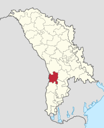
The leova district is a Raion in the Republic of Moldova . The capital of the Rajons is Leova .
geography
The Rajon is located in the southwest of the country on the border with Romania along the Prut River . Leova borders the Rajons Cantemir , Cimişlia and Hînceşti and to the Autonomous Region of Gagauzia .
In addition to the capital, Iargara has the town charter , the rest of the area of the Rajons is distributed to rural communities.
history
Remains of the ancient fortification line of the Trajan's Wall can be seen north of the capital Leova . The Leova Rajon has existed since 2003. Until February 2003, the area belonged to the now dissolved Lăpuşna district (Județul Lăpuşna) together with today's Basarabeasca , Cimişlia and Hînceşti districts.
population
Population development
In 1959 there were 38,809 inhabitants in the area of today's Rajons. In the decades that followed, the number of inhabitants increased steadily: from 49,510 in 1970 to 53,414 in 1979 to 55,354 in 1989. By 2004, as in the whole of Moldova, the population of the Rajon fell, which was 51,056 in that year. In 2014 it was 44,702.
Ethnic groups
According to the 2004 census, the Moldovans represent the largest ethnic group in Leova Raion with 85.5%, followed by the Bulgarians with 7.5%, whose proportion is well above the nationwide figure of 1.9%. Smaller minorities are the Ukrainians with 2.4%, the Russians with 2.3%, the Romanians with 0.9% and the Gagauz with 0.8%.
Individual evidence
- ↑ a b http://www.statistica.md/public/files/Recensamint/Recensamintul_populatiei/vol_1/1_Toate_recensaminteleRne_ro.xls
- ↑ Archived copy ( Memento of the original dated February 4, 2009 in the Internet Archive ) Info: The archive link was inserted automatically and has not yet been checked. Please check the original and archive link according to the instructions and then remove this notice.
- ^ Moldova: administrative structure (districts and municipalities) - population figures, graphics and map. Retrieved May 9, 2018 .
- ↑ http://www.statistica.md/public/files/Recensamint/Recensamintul_populatiei/vol_1/6_Nationalitati_de_baza_ro.xls
Web links
Rajons:
Anenii Noi |
Basarabeasca |
Briceni |
Cahul |
Cantemir |
Călărași |
Căușeni |
Cimișlia |
Criuleni |
Dondușeni |
Drochia |
Dubăsari |
Edineț |
Fălești |
Florești |
Glodeni |
Hînceşti |
Ialoveni |
Leova |
Nisporeni |
Ocnița |
Orhei |
Rezina |
Rîșcani |
Singing |
Soroca |
Strășeni |
Șoldăneşti |
Ștefan Vodă |
Taraclia |
Teleneşti |
Ungheni
Autonomous regions: Gagauzia |
Transnistria
![]()
![]()