
Liberecký kraj
|
Liberecký kraj Reichenberg region |
|
|---|---|
 |
 |
| map | |
  |
|
| Basic data | |
| Historic country : | Bohemia |
| Administrative headquarters : | Liberec |
| Biggest town: | Liberec |
| ISO 3166-2 : | CZ-51 |
| Residents : | 442,356 (January 1, 2019) |
| Population density : | 139 inhabitants / km² |
| Vehicle registration number : | L. |
| geography | |
| Area : | 3,163 km² |
| Expansion: | North-South: 28 - 56 km West-East: up to 86 km |
| The highest point: | 1.435 nm |
| Deepest point: | 208 m nm |
| structure | |
| Districts : | 4th |
| Municipalities : | 216 |
| administration | |
| Hejtman: | Martin Půta ( STAN ) |
| Website: | www.kraj-lbc.cz |
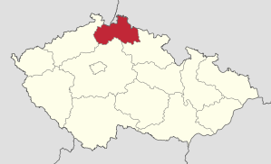
The Liberecký kraj ( German Reichenberger Region ) is one of the 14 regions in the Czech Republic . The smallest Czech region in terms of area (apart from the capital Prague) is in the north-east of Bohemia . The administrative seat is in Liberec (German Reichenberg ). This is where the triangle of Germany , Poland and the Czech Republic is located .
landscape
The district includes the north of the Česká kotlina (German Bohemian basin ), Jizerské hory (German Jizera Mountains ), western Krkonoše with the foothills ( Giant Mountains ) and the eastern part of the Lusatian Mountains . In the north, the district borders on Germany for 20 km and on Poland for 130 km . The Bohemian regions Königgrätz , Central Bohemia and Aussig follow in clockwise direction . The district is mostly mountainous. The highest point is the Kotel (German Kesselkoppe ) not far from Harrachov (German Harrachsdorf ) and Rokytnice nad Jizerou (German Rochlitz an der Iser ) at 1,435 m above sea level. M., the lowest point at 208 m above sea level. M. the area in which the river Smědá (German Wittig ) leaves the territory of the Czech Republic. A well-known mountain is the Ještěd (German Jeschken ) on the western outskirts of Liberec at 1,012 m above sea level. M .; the north-eastern part belongs to the colder regions, the western and south-western parts to the slightly warmer areas. The water is mostly collected in three rivers, the Ploučnice (German Polzen ), Lausitzer Neisse and the Jizera (German Iser ). There are also mineral springs and healing moors in the district.
surface
The district occupies 4.0% of the total area of the Czech Republic. With the exception of Prague, it is the smallest district in the Czech Republic with 3,163 km² . Agriculturally usable land takes up 22.3% and is thus far below the national average. The forest area has a high share of this with 44.2%.
raw materials
There are deposits of high-quality glass and foundry sands in the district. The decorative and building blocks broken here are also known. In Okres Semily is hard coal promoted. In Česká Lípa District was until very recently, uranium promoted.
Demographics
On January 1, 2017, the district had 440,636 inhabitants (4.2% of the population of the Czech Republic). The population density in 2012 was 138.6 inhabitants per km² and was slightly above the national average. The highest concentration was reached in Okres Jablonec nad Nisou with 219 inhabitants per km². There are 216 communities in the district. 5.9% of the district live in places with fewer than 500 inhabitants. 78.0% of the population live in cities. The center of the district is the district town of Liberec with around one hundred thousand inhabitants. The average age of 41.8 years is slightly below the national average. Due to the low birth rate, the district is aging, although Okres Česká Lípa has the lowest average age in the Czech Republic.
Biggest cities
| city | Residents (January 1, 2017) |
|---|---|
| Liberec | 103,853 |
| Jablonec nad Nisou | 45,702 |
| Česká Lípa | 37.201 |
| Turnov | 14,330 |
| Nový Bor | 11,826 |
| Semily | 8,472 |
| Hrádek nad Nisou | 7,645 |
| Frýdlant v Čechách | 7,536 |
| Mimoň | 6,470 |
| Tanvald | 6,389 |
| Chrastava | 6,189 |
| Železný Brod | 6,070 |
| Lomnice nad Popelkou | 5,581 |
| Jilemnice | 5,470 |
| Doksy | 5,168 |
economy
The district is heavily industrialized. The glass and jewelry industry, plastics processing, mechanical engineering and automotive suppliers play important roles. The traditional textile industry is becoming less and less important. In agriculture, which hardly plays a role, grain and forage crops are grown. In the second half of the 1990s in particular, a large number of foreign companies settled in the district. There is also growth in trade and tourism.
Economic indicators
The district has a 3.5% share in the Czech Republic's gross domestic product .
labour market
The restructuring of the industry and the shutdown of uranium mining contributed significantly to unemployment. At 4.93% at the end of March 2017, it was slightly above the national average (4.79%). The earnings are below the national average and amount to CZK 15,102 .
Transport infrastructure
The total length of the rail network is 543 km and is well above the average in the Czech Republic. The main artery is the expressway from Praha to Liberec , other important arteries connect the district from north to south ( Svor - Česká Lípa - Mělník ) and to the west ( Děčín - Nový Bor - Chrastava -Liberec- Turnov - Hradec Králové ). 20% of the roads belong to category 2, 66.5% to category 3.
environment
The growing mobilization has a negative effect on the quality of life. Thermal power plants also contribute to air pollution. About 60% of the total area of the district belongs to the water protection area, the highest proportion in the Czech Republic. Due to the variety of ecosystems, 115 small-scale protected areas (8 national nature reserves, 8 national natural monuments, 35 nature reserves and 64 natural monuments) and 9 large-scale protected areas (1 national park, 5 landscape protection areas, 3 nature parks) were designated in the district.
See also: List of nature reserves in Liberecký kraj
Social facilities
School system
In addition to primary schools, there are also special schools for the physically and mentally handicapped in the district. Since 1990 the number of grammar schools has increased while the number of specialized grammar schools has decreased. In Liberec there is the Technical University of Liberec . In addition to the subjects of mechanical engineering and textile technology (the only faculty in this field in the Czech Republic), education , economics , architecture , mechatronics and engineering are taught.
Healthcare
A total of 10 hospitals, the largest in Liberec, are located in the district. In Vysoká nad Jizerou there is a special clinic for plastic surgery and hand surgery . In addition, two health resorts ( Lázně Libverda and Lázně Kunratice ) provide rehabilitation for the sick. They specialize in exercise therapy, heart disease and rheumatism .
Culture
The district had an eventful history, which is reflected in numerous monuments. The history can be traced in the Severočeské muzeum in Liberec , you can also visit the gallery and the scientific library in this town, as well as the FX Šalda Theater, the Naive Theater , the Botanical Garden and the zoo . In addition to 257 libraries, you can visit other museums, galleries and traveling theaters in the district.
tourism
Invite to the historically valuable monuments, guests at the district to visit include the castles ( Bezděz , Zákupy Chateau , Lemberk Castle , Castle Frydlant , Sychrov , castle Hrubý Rohozec , Valdštejn ) and a number of churches. There are also many lakes such as Máchovo jezero . Around 50,000 beds are available to visitors. In addition, the individual vacation also plays an important role. Numerous cottages and pensions, especially in the Česká Lípa and Semily districts, offer good comfort. Active winter and summer holidays are mainly carried out in the mountains of the region ( Giant Mountains , Jizera Mountains , Český ráj , Doksy , Lusatian Mountains , Ore Mountains ).
politics

In the 2016 district elections, as in 2012, a group of regional mayors (Starostové pro Liberecký kraj) won with 32.35% of the votes and thus received 18 of the 45 seats in the district council. The second strongest force was ANO with 17.08% of the vote (9 seats). The communist KSČM (8.1%), ČSSD (8.04%), ODS (7.91%) and another regional electoral association (7.06%, ZMĚNA PRO LIBERECKÝ KRAJ) received 4 seats each . The remaining 2 seats went to SPO + SPD (5.2%).
District captain remained Martin Půta ( STAN ), who had already taken over this office from the social democrat Stanislav Eichler after the previous elections in 2012. Půta was previously mayor of the city of Hrádek nad Nisou .
International partnerships
The Reichenberg region has had a regional partnership with the canton of St. Gallen in Switzerland since 2001 .
Districts

District Cities
- Česká Lípa ( Bohemian Leipa )
- Jablonec nad Nisou ( Gablonz )
- Liberec ( Reichenberg )
- Semily
Web links
- Homepage of the region (cz / en / de)
- Czech Statistical Office: statistical information on the region (cz / en)
Individual evidence
- ↑ http://www.uir.cz/kraj/78/Kraj-Liberecky
- ^ Ing. Martin Modrý, Ph.D. and RNDr. Jarmila Sýkorová: Small-scale protected areas in the Liberec region, 2011, publisher: Society for the Lusatian Mountains
- ↑ rozdělení křesel. Retrieved September 24, 2017 (Czech).
- ↑ External relations of the canton of St.Gallen - partner regions. Canton of St. Gallen (www.sg.ch), accessed on April 21, 2014 : "In 2001 the Liberec region and the canton of St. Gallen concluded an agreement on regional cooperation."
Coordinates: 50 ° 43 ' N , 15 ° 0' E