
Dürbheim
| coat of arms | Germany map | |
|---|---|---|

|
Coordinates: 48 ° 3 ' N , 8 ° 48' E |
|
| Basic data | ||
| State : | Baden-Württemberg | |
| Administrative region : | Freiburg | |
| County : | Tuttlingen | |
| Height : | 727 m above sea level NHN | |
| Area : | 14.82 km 2 | |
| Residents: | 1681 (December 31, 2018) | |
| Population density : | 113 inhabitants per km 2 | |
| Postal code : | 78589 | |
| Area code : | 07424 | |
| License plate : | DOES | |
| Community key : | 08 3 27 011 | |
| LOCODE : | DE DBH | |
| Address of the municipal administration: |
Probststrasse 2 78589 Dürbheim |
|
| Website : | ||
| Mayor : | Andreas Häse | |
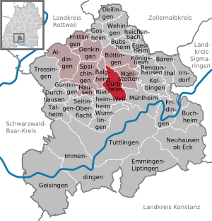
| Location of the municipality of Dürbheim in the Tuttlingen district | ||
  |
||


Dürbheim is a municipality in the district of Tuttlingen in Baden-Württemberg , Germany .
geography
Geographical location
Dürbheim lies at the foot of the Swabian Alb at 677 to 973 m above sea level. NHN , about nine kilometers north of the district town of Tuttlingen . Surrounded to the east by the forests of the Albtraufs , new development areas extend in a semicircle around the older town center of the industrialized community. The hamlet of Risiberg on the Alb plateau already belongs to the Großer Heuberg . The community lies on the main European watershed Rhine - Danube . There is the source of the Faulenbach , which flows over the Elta into the Danube; The Prim rises a good kilometer to the north and flows into the Neckar in Rottweil .
Neighboring communities
The municipality is bordered to the north by Böttingen , on the east by Mahlstetten , on the southeast by Mülheim an der Donau and over the district Nendingen in Tuttlingen , south to Wurmlingen and Rietheim-Weilheim and in the northwest on Balgheim . Dürbheim only touches the districts of Wurmlingen and Mühlheim at a single point in Ursental .
structure
The village of Dürbheim and the hamlet Risiberg belong to the municipality of Dürbheim. The lost castles Burghalde and Wallenburg are located in the municipality .
history
Dürbheim was first mentioned in a document in 786 in connection with the possessions of the St. Gallen monastery . A recently found small burial place, which belonged to a single courtyard of a nobleman, and traces of a small wooden church from around 700 indicate an earlier settlement. The ruins of Burghalde Dürbheim are on the district. During the time of the tribal duchies , the place was in the Duchy of Swabia . After the dissolution of the tribal duchy, the place belonged to the territory of the Counts of Hohenberg . As part of the upper county of Hohenberg, the village remained in front of Austria before it became part of Württemberg in 1805 .
In the Kingdom of Württemberg the place was assigned to the Oberamt Spaichingen . During the regional reform in 1938, the place became part of the Tuttlingen district .
politics
Administrative community
The community is a member of the agreed administrative community of the city of Spaichingen .
coat of arms
|
|
Blazon : "In silver (white) a jumping red stag." |
| Founding of the coat of arms: The coat of arms, first awarded in 1930 and last on September 20, 1967, is derived from a seal showing the stag. The design of the coat of arms had been agreed with the Stuttgart archives department. The colors red and silver refer to the former dominions Grafschaft Hohenberg and Austria . |
Banner and flag
 |
Banner: "The banner is red and white striped lengthways with the coat of arms above the middle." |
 |
Hoisted flag: "The flag has red and white stripes with the coat of arms in the middle." |
Partnerships
Since the village festival in 2006, Dürbheim and Fertőd have been partner communities.
Economy and Infrastructure
In the TUTicket transport association , Dürbheim can be reached by bus route 19 Bubsheim – Rietheim – Spaichingen and bus route 42 Spaichingen – Tuttlingen. In Rietheim you can change to the ring train in the direction of Rottweil or Tuttlingen.
Culture and sights
_2.jpg)
Dürbheim is located on the Swabian Albstraße , which leads past many sights. The municipality is affiliated with the "Donaubergland" tourist association.
Natural monuments
To the west of Dürbheim, directly on the European watershed, is the Dürbheimer Moor nature reserve , the source area of the Faulenbach , a high moor with an extraordinary botanical and zoological diversity that also includes the Egelsee . In addition to the flora typical of the moors, some rare bird species can be observed here.
Sports club
The Dürbheim sports club consists of several departments. The wrestling department has been the most successful so far. The Dürbheim wrestlers made it to the Württemberg regional league in the 2008/2009 season. This was followed in the 2009/2010 season with the runner-up in the state league of the "march through" in the Württemberg Association League. The runner-up in the 2014/15 season ensured promotion to the league.
Personalities
- The most famous son of Dürbheim was Bishop Johann I (1265–1328) von Dirpheim, who was court secretary and chancellor at the court of King Albrecht I around 1300 and was ordained bishop in 1305. As Bishop of Strasbourg (1306-1328), he significantly promoted the construction of the local minster.
- Bernd Glemser (* 1962), pianist and university professor
Individual evidence
- ↑ State Statistical Office Baden-Württemberg - Population by nationality and gender on December 31, 2018 (CSV file) ( help on this ).
- ^ The state of Baden-Württemberg. Official description by district and municipality. Volume VI: Freiburg region Kohlhammer, Stuttgart 1982, ISBN 3-17-007174-2 . P. 660
- ↑ Profile of the nature reserve in the LUBW's list of protected areas
- ^ Official website of Dürbheim, history
Web links
- Wikisource: Dürbheim in the description of the Oberamt Spaichingen from 1876

Aldingen | Balgheim | Bärenthal | Böttingen | Bubsheim | Buchheim | Deilingen | Denkingen | Dürbheim | Durchhausen | Egesheim | Emmingen-Liptingen | Fridingen an der Donau | Frittlingen | Geisingen | Gosheim | Gunningen | Hausen ob Verena | Immendingen | Irndorf | Kolbingen | Koenigsheim | Mahlstetten | Mühlheim an der Donau | Neuhausen ob Eck | Reichenbach am Heuberg | Renquishausen | Rietheim-Weilheim | Seitingen surface | Spaichingen | Talheim | Trossingen | Tuttlingen | Wehingen | Wormlings