
Rott (Landsberg am Lech district)
| coat of arms | Germany map | |
|---|---|---|

|
Coordinates: 47 ° 54 ' N , 10 ° 58' E |
|
| Basic data | ||
| State : | Bavaria | |
| Administrative region : | Upper Bavaria | |
| County : | Landsberg am Lech | |
| Management Community : | Reichling | |
| Height : | 702 m above sea level NHN | |
| Area : | 19.74 km 2 | |
| Residents: | 1651 (Dec. 31, 2019) | |
| Population density : | 84 inhabitants per km 2 | |
| Postal code : | 86935 | |
| Area code : | 08869 | |
| License plate : | LL | |
| Community key : | 09 1 81 137 | |
| Community structure: | 5 parts of the community | |
| Address of the municipal administration: |
Weilheimer Strasse 16 86935 Rott |
|
| Website : | ||
| Mayor : | Quirin Krötz | |
| Location of the municipality of Rott in the Landsberg am Lech district | ||
 |
||


Rott is a municipality in the Upper Bavarian district of Landsberg am Lech and a member of the Reichling administrative community .
geography
Rott is located between Landsberg and Weilheim and between Ammersee and Lech at the intersection of the roads from Weilheim to Landsberg and from Dießen to Schongau in the so-called Lechrain area , about four kilometers northwest of the well-known monastery village of Wessobrunn .
The municipal area includes the Eichberg or Kalvarienberg , a moraine hill which, at 753 m, is one of the highest points in the Landsberg district, and Lake Engelsried, located about two kilometers south in a high moor . The place is located on a gently sloping southern slope in a glacial moraine landscape . The Bayerdießen forest extends east of Rott .
The municipality has five officially named municipal parts (the type of settlement is given in brackets ):
- Felderhof ( wasteland )
- Pessenhausen ( village )
- Riedhof (wasteland)
- Rott ( parish village )
- Strausshof (wasteland)
history
Until the church is planted
A first settlement can be proven on the basis of barrows in the Hallstatt period. A Celtic square hill between Rott and Reichling comes from the La Tène period . In Roman times, the road from Epfach (Abodiakum) to Raisting (Urusa) ran across what is now the municipality. Evidence of Roman settlement has not yet been discovered, but a bronze bust of the Roman god Bacchus was found, which is now exhibited in the Prehistoric State Collection in Munich . The Germanic row graves in the local area are dated to the 7th century AD.
The place name Rott is first mentioned as Rota in 1078 and is derived from the Rottbach , which rises above the Engelsrieder See , which was created in 1510 and feeds it. The name could come from Germanic times and refer to the red-brown color of the river water. Rota can also be interpreted in Indo-European as 'rushing water'.
In the 13th century, Rott came to rule the Wessobrunn monastery . In 1397 19, around 1800 43 of the 54 properties in Rott belong to the Klosterhofmark. With the incorporation of the parish after Wessobrunn in 1226, the parish only regained the status of an independent parish after the secularization in 1803 and was able to develop into an independent unit in economic and social terms.
Population development
Rott experienced a serious change after the Second World War , when the village, which had around 600 inhabitants at the time, had to take in 300 displaced people . As a result, Rott developed from a traditional farming village to a more industrial community with a growing proportion of commuters.
The population from 1840 onwards relates to the area of the municipality today.
| Population development | |||||||||||||||
|---|---|---|---|---|---|---|---|---|---|---|---|---|---|---|---|
| year | 1840 | 1900 | 1939 | 1950 | 1961 | 1970 | 1987 | 1991 | 1995 | 2000 | 2005 | 2010 | 2015 | 2018 | 2019 |
| Residents | 371 | 626 | 608 | 991 | 925 | 961 | 1018 | 1124 | 1327 | 1418 | 1492 | 1472 | 1577 | 1618 | 1651 |
Between 1988 and 2019 the municipality grew from 1,067 to 1,651 by 584 inhabitants or by 54.7%.
coat of arms
The description of the coat of arms reads: In silver over a lowered blue wavy bar, in it a silver wooden shoe, crossed at an angle, a red key and a blue clearing ax with a red handle.
mayor
Quirin Krötz (village community) has been the mayor since May 2002.
Culture and sights
- the old parish church of St. John the Baptist in the center of the village with rich rococo decorations (stucco by Michael Merk , ceiling painting depicting the legend of St. John by Johann Baptist Baader (“Lechhansl”), sculptures by Franz Xaver Schmädl ); north of the former rectory
- the Ottilien chapel on the northern outskirts from 1483, with baroque furnishings (Michael Merk, Sebastian Jaud , Matthäus Günther ) and old votive tablets
- the new parish church of the Holy Family (consecrated in 1965) with a green cemetery
- the Kalvarienberg with the 14 stations of the cross from 1878 and the Lourdes grotto from 1894. Beautiful, shady hiking trail up the stations of the cross, then over the Kreuzberg with a wonderful view of the Alps to the Ottilien chapel
- the angel Rieder lake , about 2 km south of Rott, popular swimming lake (Moorsee) on the edge of a conservation area
- the village museum, which documents the history of Lechrain with changing exhibitions
- the nature trail and the orchard meadow at Lake Lugensee
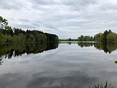
Engelsried lake

St. Johann Baptist
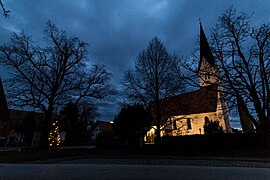
St. Johann Baptist

Village center with pharmacy and old school building
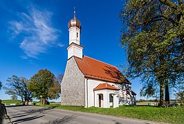
Ottilien Chapel at the entrance to the village


Soil monuments
See: List of soil monuments in Rott (Landsberg am Lech district)
Web links
- Entry on the coat of arms of Rott (Landsberg am Lech district) in the database of the House of Bavarian History
Individual evidence
- ↑ "Data 2" sheet, Statistical Report A1200C 202041 Population of the municipalities, districts and administrative districts 1st quarter 2020 (population based on the 2011 census) ( help ).
- ^ Community Rott in the local database of the Bayerische Landesbibliothek Online . Bavarian State Library, accessed on September 7, 2019.
- ^ Heide Weißhaar-Kiem: Landsberg am Lech district . Ed .: Landsberg am Lech district. 1st edition. EOS Verlag St. Ottilien, 2010, ISBN 978-3-8306-7437-5 , p. 279 .
- ↑ http://www.wahlen.bayern.de/kommunalwahlen/

Apple village | Denklingen | Dießen am Ammersee | Eching am Ammersee | Egling at the pair | Eresing | Finning | Fox Valley | Geltendorf | Greifenberg | Hofstetten | Hurlach | Igling | Kaufering | Kinsau | Landsberg am Lech | Obermeitingen | Penzing | Prittriching | Pürgen | Reichling | Rott | Scheuring | Schondorf am Ammersee | Schwifting | Thaining | Unterdießen | Utting am Ammersee | Vilgertshofen | Because | Windach
Unregulated areas: Ammersee