Ruta 3 (Bolivia)
| Ruta 3 in Bolivia | ||||||||||||||||||||||||||||||||||||||||||||||||||||||||||||||||||||||||||||||||||||||||||||||||||||||||||||||||||||||||||||||||||||||||||||||||||||||||||||||||

|
||||||||||||||||||||||||||||||||||||||||||||||||||||||||||||||||||||||||||||||||||||||||||||||||||||||||||||||||||||||||||||||||||||||||||||||||||||||||||||||||
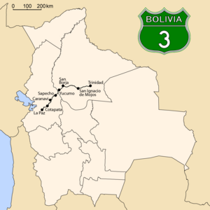
| map | ||||||||||||||||||||||||||||||||||||||||||||||||||||||||||||||||||||||||||||||||||||||||||||||||||||||||||||||||||||||||||||||||||||||||||||||||||||||||||||||||
| Basic data | ||||||||||||||||||||||||||||||||||||||||||||||||||||||||||||||||||||||||||||||||||||||||||||||||||||||||||||||||||||||||||||||||||||||||||||||||||||||||||||||||
| Operator: | Administradora Boliviana de Carreteras |
|||||||||||||||||||||||||||||||||||||||||||||||||||||||||||||||||||||||||||||||||||||||||||||||||||||||||||||||||||||||||||||||||||||||||||||||||||||||||||||||
| Start of the street: |
La Paz ( 16 ° 30 ′ S , 68 ° 10 ′ W ) |
|||||||||||||||||||||||||||||||||||||||||||||||||||||||||||||||||||||||||||||||||||||||||||||||||||||||||||||||||||||||||||||||||||||||||||||||||||||||||||||||
| End of street: |
Trinidad ( 14 ° 50 ′ S , 64 ° 54 ′ W ) |
|||||||||||||||||||||||||||||||||||||||||||||||||||||||||||||||||||||||||||||||||||||||||||||||||||||||||||||||||||||||||||||||||||||||||||||||||||||||||||||||
| Overall length: | 602 km | |||||||||||||||||||||||||||||||||||||||||||||||||||||||||||||||||||||||||||||||||||||||||||||||||||||||||||||||||||||||||||||||||||||||||||||||||||||||||||||||
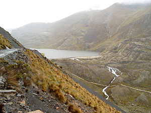
| Ruta 3 (left) at Laguna Incachaca northeast of La Paz | ||||||||||||||||||||||||||||||||||||||||||||||||||||||||||||||||||||||||||||||||||||||||||||||||||||||||||||||||||||||||||||||||||||||||||||||||||||||||||||||||
|
Course of the road
|
||||||||||||||||||||||||||||||||||||||||||||||||||||||||||||||||||||||||||||||||||||||||||||||||||||||||||||||||||||||||||||||||||||||||||||||||||||||||||||||||
The Ruta 3 is a national road in the South American Andean state of Bolivia .
Routing
The road has a length of 602 km and crosses the northern part of Bolivia from west to east, from the eastern edge of the Altiplano to the lowlands of the Río Beni . The road crosses the La Paz Department and the Beni Department . It begins in the west at the government metropolis of La Paz and ends in the east in the city of Trinidad , the capital of the Beni department. There it meets the national road Ruta 9 , which from here leads north to Guayaramerín on the border with Brazil and south-east to Yacuiba on the border with Argentina .
The routes from La Paz to Santa Bárbara , from Quiquibey to Yucumo , the 30 kilometers behind San Ignacio and from Puerto Baradero to Trinidad are paved. The rest of the route (around two thirds) is still gravel or dirt road, but is currently paved (as of 2018).
history
Until 2006, the first part of Ruta 3 from La Paz to Coroico consisted of the infamous Yungas Strait , which the Inter-American Development Bank named in 1995 as the "most dangerous road in the world". This section has been paved since 2006 and, from kilometer 54, has been replaced by a completely new road construction, which is only slightly longer than the original road, but significantly less dangerous than this.
The Ruta 3 was declared part of the Bolivian national road network " Red Vial Fundamental " by decree 25.134 of August 31, 1998 .
Route sections
La Paz Department
- km 00: La Paz
- km 015: Laguna Incachaca
- km 023: La Cumbre
- km 031: Pongo Rinconada
- km 037: Pongo
- km 043: Unduavi
- km 052: Cotapata
- Km 057.4 to 058.8: San Rafael Tunnel
- km 094: San José de Chicalulo
- km 095: Yolosa
- km 101: Santa Bárbara
- Km 105: San Martín de Padilla
- Km 109: Quenallata
- km 112: Challah
- km 128: Choro
- Km 131: San Pedro de Caranavi
- km 141: Chojña
- km 163: Caranavi
- Km 215: Bella Vista
- km 231: Sapecho
- km 253: Inicua
Beni Department
- km 284: Quiquibey
- km 301: 6 de Agosto
- km 307: Libertad Unida
- km 322: Yucumo
- km 370: San Borja
- km 375: Tierra Santa
- km 377: Galilea
- km 420: Totaizal
- km 509: San Ignacio de Moxos
- km 589: Puerto Barador
- km 594: Puerto Almacén
- km 602: Trinidad

